
Page re write on way once I can get WordPress menus sorted.
New pictures too since the old ones are stuck on the old server.
12 Jun 2010
Ordered one today with Heartrate and Cadence. Hopefully it will get it’s first airing on Sunday.
27 April 2009
A year on there is a lot of traffic for this page, a lot has happened in the last year and It’s all been captured in the comments now nearing 400.
Well it turned up as promised and comes preloaded with a Garmin base map. Now a base map is hardly the most useful map to ride with except if you like riding A roads and motorways.
If your looking at buying a 705 or 605 get a bundle with a Garmin Map. I’ve already got a couple of maps through Ebay and they make or break your enjoyment of Garmin Edge products.
Nov 08 You could always try the OSM maps. It’s free and includes cycle routes.
http://www.mapomatic.net/garmin-maps-download/ Link not working. I’ll find another 27 Apr 09
Thanks to Dave for the link. Coverage is good but not total. Just started using it over a Garmin map to see how I get on with it. The cycleroute features are a bonus.
Out of the box the 705 isn’t recognised by Training Centre or MapSource. You need the latest version of TrainingCentre downloaded and installed along with new USB drivers.
These do not come in the box, be warned. Restart your computer to activate the USB drivers.
I hotfooted it down to Costco for a 2gb microSD card for £8.21.
For some reason I could only put 460mB of maps on the card. This was the whole of Topo GB less a bit of Scotland. The hardest part was selecting the data to export when you haven’t done it before. Again it’s not as if you’ve got a book to examine.
The whole point of the 305 was navigating a Route, the trouble was the TrainingCentre didn’t support Routes.This is why the third party sites like Marengo have sprung up. They address the deficiencies in the Garmin software.
Download Mapsource, your a Garmin user and it is free, also download Nroute while you are at it. MapSource is where your Garmin maps reside they are vector maps and a bit different to OS scanned maps.
I hooked up the 305 and downloaded the Hawk200 route into MapSource. Then exported it to the 705. I couldn’t find any Routes on the 705 but it was under Where To/Saved Rides. You are given the option of Navigating or Saving to SD when toggling the button.
I’ll cut to the Find option as this now lists all the POI (points of interest) that you get with the automotive Garmins. The Cafe across the road is listed along with ATMs, Hotels etc along with auto routing to them.
Going to try it out in earnest tomorrow. It looks really good I just hope the battery life is up to it.
I’ve been asked a couple of times is a 305 up for long ride such as LEGOG or longer. Well it isn’t. A Garmin Edge 705 with the right map is up for it as it can reroute you automatically.
The manual doesn’t mention Routes but they are still going to be an important part of an Edge 705 experience. The whole point of an Edge is to get off those main roads and direct routes to get on those quiet roads and lanes.
More to follow including a few pictures when I get around to it.
The 48 year old kid has a new toy.

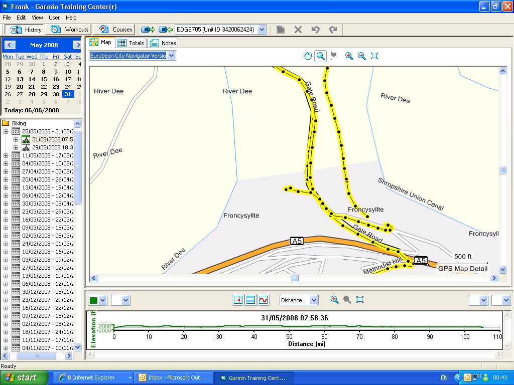


![]() The first picture is the new toy in action for the first time. The route for the Brimstage Time Trial is on the screen the second is a picture of the start. This is where all my rides start now. Rest Hill did have a good ring to it.
The first picture is the new toy in action for the first time. The route for the Brimstage Time Trial is on the screen the second is a picture of the start. This is where all my rides start now. Rest Hill did have a good ring to it.
No warm up for this Time Trial, just pressed Start and went for it. I’ve a set of low end carbon wheels with tubs for the real thing. I won’t have the bag on the back either.
It went really well, wind wasn’t in my favour but I was happy with the colour display in broad daylight. The lights at the Thornton Hough turnoff had a tailback of cars at them and I went up the inside at over 20 mph. Is it better than an Edge 305? Sure it is, it should stop all the moaners that come on here decrying the Edge 305 as a training aid.
A 305 is still a great device. I’m taking mine on tomorrow’s ride as backup. Cadence sensor worked and computed the wheelsize about half a mile into the time trial.
Thats it for now, any questions just ask.
Monday: This evening is all about seeing what Garmin Connect is all about. I’ve installed the Garmin Communicator driver and didn’t have much success last night after the Audax.
![]()
Garmin Connect is still a work in progress. I’d like to see more Map and less white space.
For the map lovers there is now Longitude and Latitude. There is no battery life icon anymore which is an item I would still like to see. It wasn’t a problem for me on the Audax but Phil had the 305 12 hour low battery life warning. I’d took a £2 phone top-up charger from Maplin just in case.
 Click to enlarge.
TrainingCentre is still pretty much the same and must still be the preferred method of analysing data. Next up is MotionBased, the data on here is vast, too vast not to incorporate it into Garmin Connect. How would you placate me with well over 100 quality rides. Only to be told well they don’t count anymore because we have changed the system. I’ve also paid for the storage too. Too early to say but Garmin Connect maybe not the choice of serious users. The Facebook and Bebo links sort of give it away and it’s not a scene I am into.
At the moment GPS is the exception rather than the rule for cycling. Devices like the 705 add maps to the logging that the 305/205 did so well. If your still looking for a nice pleasant ride use somebodies else’s route as it ain’t going to come out of a SatNav. I still only use the routing functions for events, most of the time is just spent logging.
Deleting Waypoints is starting to be a bit of a problem. Keith brought it to my attention and although I tried the method in the manual it keeps putting them back.
http://forums.motionbased.com/smf/index.php?topic=8158.0
This needs sorting asap. I’d also like to to delete the places searched for.
16 Apr 08 Spent about an hour or so trying to delete waypoints so I can upload a new route into the 705. Google maps still has the edge over Mapsource when planning a route but the road following feature is nice. (Now sorted with 2.20 upgrade 18 Jun 08)
17 Apr 08 Had a look at google Analytics for the first time in a while. Over 4000 hits for a rolling month for the first time. This page is well in the top 10. Always pleased to see the diet link in the top 10 with over 300 people linking to it.
Thanks for all the comments so far, there is a lot of sound advice in them. I’ll incorporate some of them into this page so the search engines will pick up on them. I’ll be trying a Course soon to see what it looks like. Brimstage 7 mile TT should be just the thing.
19 Apr 08 One problem I am having is deleting Recent Finds there seems to be no way of deleting them at the moment. More on this when I sort it.
Don’t edit your profile on the Edge send it to the Edge from the Training Centre this way if you don’t get asked which profile to use. If you change profiles you loose your History and you don’t want to do that EVER.
25 Apr 08 Here is a link to the Garmin downloads page for Mapsource and other downloads.
http://www8.garmin.com/support/mappingsw.jsp
09 May 08 Update on the difference between Points on an Edge. Thanks to Dave for posting the Question.
Trackpoints: Your log of the route taken once you’ve pressed the start button. (nothing is logged until you press Start.)
Waypoints:Used as part of a Route. You Navigate a Route, the compass page is enabled and it always points to the next waypoint.
Which when you plan your Route will be a road junction. If you name your waypoint with the turn direction (RT/LT) you get an instant signal on which way to turn at the junction. 100 Waypoint limit
CoursePoints:Built in to your Edge. Another 100 Coursepoint limit but harder to program as they can only be added to a Course(previous ride) using the TrainingCentre. You need a Garmin Map for it to be useful. CoursePoints behave like Waypoints in that you get the bleeps and countdown to the junction. Not widely used as it is fiddley to program. Not supported by many third party applications.
10 May 08 Update Now getting 5100 hits a month and 1700 just on this page. As you may gather lots of comments too. A lot of you are having problems with planning Routes partly this is the result of the other third party Google based route planners all offering something slightly different. Partly the legacy of the Edge305 not having built in maps. So here is my roundup of the Google route planners.
Marengo Plots Routesusing the 100 Garmin waypoints. Straight forward, works, saves to 305 via GPSBabel, 705 via MapSource.GPX format. Free registration.
MapMyRide Plots Coursesno 100 waypoint limit but a Course is not a route. Small map area due to adverts and sidebar. Free registration.
BikeRouteToaster Plots Courses but with CoursePoints. CoursePoints are built into your Edge and there is no 100 waypoint limit. Some nice features in this software. 17,000 points in a 705 so a should plot a long course. No Waypoints.
29 May 08Update. Just had a comment from Dave F about Garmin Maps on microSD cards. Comment 80. If your starting from scratch with no Garmin Maps you need the CD or DVD version of the Map. A microSD Card map will not upload to your PC.
The bad news is that it now £400 for that bundle compared to £350 for the microSD bundle. I’ve seen the card version for £50. More later
30 May 08I think the waypoint deletion problem is now sorted after the latest upgrade. It seemed to work OK for me with tomorrows big ride coming up.
********* IMPORTANT*********
Before you purchase your 605/705 you need to decide if you want the Dvd map or the SD card map. TrainingCentre and MapSource need the Dvd map. You cannot upload the SDcard map into TrainingCentre.
The SD card map will work straight out the box but means you won’t be able to see that much detail in TrainingCentre or MapSource.
Topo products are not the same as the Digital Maps such as TrackLogs, Anquet in the UK they are vector maps and look a lot different than a 1:50,000 Ordnance Survey map.
SD card maps are cheaper than DVD maps.
With DVD maps you export the map area you are interested in into your microSD card.
It makes sense to do a search for the bundle you require as in my eyes you are looking at a significant amount of money for what many would regard as a toy for a bike.
Thanks to DaveF for pointing out the difference. Comment 80.


If your new to the Garmin Maps the above screenshots illustrate the difference between the BaseMap in your 605/705 and a CD or DVD Garmin map product. TopoGB looks very similar too but with contours. TopoGB is not comparable to a UK Ordnance Survey map as A, it uses vector technology and B it has no scale. It will however download onto your Edge memory card.
18 June 08 ********** Multiple Routes ************
Thanks to bumping in to Graham on the Bob Clift Memorial ride the Multiple Route problem is sorted. He has just done LEJOG on his 705 and it is just down to a subtle difference in how you export your Route into the Edge.
Do notuse MapSource to export multiple Routes, all it does is append the Routes into a file called Temp in the Garmin/GPX folder. (100 Waypoint limit)
All you do is open up your Memory Card/Garmin/Gpx folder. Then open up My Documents and drag and drop the GPX Routes across. I’ve just drag and dropped 11 Audax rides across and before that I could only ever see 2 rides.
The Routes are all off Marengo so are all a series of Waypoints. They are not Courses or Tracks saved as Route just a plain Gpx series of Waypoints about 10kB in size.
Anything bigger and it not going to be a Route Gpx file.
Coupled with the Delete all Waypoints update it is a major improvement in Garmin Edge 705 useability. Multiple daylong rides are now an option without having to take a computer with you. It’s a pity Garmin didn’t explain this more fully as it is a major breathrough for long distance cyclists.
19 June 08 Just had an Email off Tracklogs saying their GPX files can be drag and dropped into the Edge 705 here is the text.
Hot Developments.
We’ll be using this section at the end of our newsletter to let you know what our developers are up to. No prizes for guessing we’ve been focused on web development recently. With the new website complete and launched we’re now turning our attention to new GPS units coming out of Garmin and how best to support them. Of the new GPS models the Edge cycle computers are generating the most interest, particuarly the Edge 705. Initial tests show our GPX files can be dragged direct into these units, direct support is on its way. http://www.tracklogs.co.uk
13 July 08 Time to add a 705 Route Planning Tutorial. It’s very similar to a Edge 305 Route but the means of getting it into your 705 is different.
Just to reinforce what a Route is. A Route is a series of 100 Waypoints that you ride to. At a Waypoint (junction) you will get a bleep and a countdown to the junction. If you name the Waypoint as your turn direction (ala Marengo) you will instantly know which way to turn.
31 Oct 08 Using your 705 at night. You can ride a Course at night and use CoursePoints to warn you of the turns. The Edge turns the backlight on when gives a warning signal. This can be a Waypoint, CoursePoint, OffCourse or paused message. It’ll stay lit for the length of the backlight timer setting.
If you want to see the screen at night pressing the power button once will bring the backlight to 50% as will the toggle button, sideways will not alter the screen your on.
09 Jan 09software version update to 2.60. First thing to hit me was more options on lack of satelite reception. Time to go through all the options again to see what has changed.
27 Apr 09 GarminConnect is starting to get it’s act together, with the player useful for sharing your rides with others.
24 Jan2010 For basic mapping and any other problems you should be looking to the Garmin Gonnect forum. The phone lines are still usefull for a specific problem that isn’t covered on this blog. I hope to convert to a forum to unable more invidual input.
Regards,
Frank.

Frank,
What’s it like for navigation? Does it take you away from main roads and is Garmin Topo enough to navigate with?
Cheers,
Dave.
Dave, there is an offroad version in it. It is something I’ll have to look into. Other than that it’s just like a 305 except the screen is colour. I’ve put Topo GB2 on the microSD card no problem.
It is also loaded with all the POI,s Shops, Restaurants ATMs so if you need cash on a ride it’ll take you there.
Regards,
Frank.
Sorry, what I meant is, can you tell the unit that you want to get to Loggerheads (off the top of my head) and it will navigate a route for you (hopefully avoiding main roads/motorways)?
Dave.
Dave,
The Edge 705 doesn’t do Locations, the only way I could get it to route was to save a Waypoint at Loggerheads. Once Loggerheads gets a POI like a cash machine its never going to feature on a 705.
Cross Country routing is as the crow flies, Road Routing is the same as the the Car Satnavs, Major Roads first which is a pity.
If you have the road maps rather than the topo ones will cross country give you as shortest road route? or will it just not give you that option?
I want to do LEJOG next year and, in theory, it seems like the ideal navigator if you can get it to guide you where you want to go rather than trying to take you straight up the motorways (or whatever). The waypoint limit could be a problem – but wondered if they can be juggled between the unit & the SD card or something – or the possibility of creating the route as courses (possibly by conversion from another format) without having previously ridden them. I might just get one anyway & see if I can beat it into submission (metaphorically at least)!
Lots of questions for now – now many answers yet.
Frank if you put city navigator on you can auto route either by scrolling to a town and clicking enter or looking up a town from the navigator list. the unit will map a route for you by road. Also if you didn’t know the full manual is on garmins website.
Click to access Edge605_OwnersManual.pdf
Paul is right (sent you an email, Frank), City Navigator is far superior. It’s a shame that the retailers for this device weren’t able to offer any useful advice on map choice 😦
Dave.
Paul, Dave I\’ve City Navigator V6 that I haven\’t tried on the 705 yet. City Select does routing and placename search. Topo GB seems the poor choice for the Edge. It looks a bit better with the contours but in real life it\’s only going to be of any use to walkers and maybe Mountain bikers.
The manual is still very poor for a device this complex, it is little better than the Edge 305 manual.
I can see why Tracklogs and MemoryMap are prefered by the Mountainbike community. On a PC you get a whole lot more bells and whistles than you get on MapSource.
Regards,
Frank.
I agree if using topoGB its still best to make tracks or routes on memory map for mountain biking and save to device as a .gpx, oh and memory map say they are working on compatability with the 705. For road riding city navigator is great.
Frank
Got my Edge 705 last week and also mapsource Navigator NT, it is a great bit of kit but will need some software updates to fix a few bugs I have already found. Mapsource is okay but can be a bit fiddly to create long routes but you can only copy 1 route at a time to the unit, at present if you copy a 2nd route it overwrites the 1st route on the unit, you can workaround this by saving 1 route to the unit and the other to the SD card but the bototm line is you are limited, this is a serious limitation for someone like me who wants to do the LEJOG and though I could just create one route per day, however I contacted Garmin and they think this is a bug and will be fixed. Other than that a great piece of kit.
Frank sorry to hijack your blog but Max if you create a route in mapsource then save as a .gpx (under file save as)on your computer,you can then copy to the gpx folder on the edge. Ive got ten routes saved this way hope this helps.
Hi Frank,
Just trying to get to grips with my new Edge605 and routes. I have managed to plot a route on Memory Map, convert the file to .gpx using ‘GPS Utility’ software and then connect my 605 to the PC, where I copy the .gpx file into the GPX folder on the device.
Going to the menu of the 605, I go to saved rides and there are my route(s) – all okay so far. But when I click on a route and click ‘navigate’ it tries to route me to the separate waypoints via the nearest main road!!! (as opposed to directing my in a straight line between waypoints).
I have tried going into the settings and turning off things like ‘follow roads’, etc. but on the map view is still shows the route going to/from the nearest main road.
I have checked the .gpx files and they show a clear line linking between the waypoints, but the 605 doesn’t seem to what to follow the direct route.
Any help you can give before I through my new toy out of the pram will be appreciated…
Frank also sorry to hijack your blog but hopefully its all for the greater good of cyclists using garmin edge 705’s. Paul thanks for that it works a treat and means I can plan my LEJOG days without waiting for Garmin to fix the problem whereby sending routes to your device using the “send to device” feature within mapsource just overwrites the last file sent. Many thanks.
Paul, one final thing is there any difference between saving a route as GDB v3 format and GPX format ? Will it make any difference regarding the units ability to provide turn by turn directions and forthcoming turnings warnings ? Thanks again, is there any other way to exchange information and ask questions other than blogging up Franks blog as I feel a touch guilty or is this the point of this so all interested parties can see useful information ? Thanks again
Keith, what map are you using in Edge?
Also under Settings Routing I have it set to Follow Road and avoid Major Streets.
I haven’t used mine an the base map yet but it sounds like an odd problem. Some of the utilities don’t seem to like the 605/705 for some reason.
Max your not Hijacking the blog the are about 1500 visitors a month just looking at the Edge stuff. There are loads of people with the same problems we have.
Sounds like your going to be the first one to do LEJOG on a 705. Let us know how you get on.
Max both formats work the same on the edge but if you save your route as a .gpx and want to open it in mapsource again each waypoint direction will be as the crow flies. Best way in my opinion is to save your routes in mapsource as .gdb format and then save as .gpx as well if you are sending to the edge.
Keith if you create a route in memory map it will try to follow roads best way is to create tracks if you want direct route from waypoint to waypoint. also when you have created your track you can save as a .gpx by clicking on track, click save as, enter name then choose gps exchange files from the drop down list. No need for gps utility.
Frank – I’m using the base map on the Edge – frustrating thing is it seems as though I wouldn’t have this problem with a 205/305 as the unit wouldn’t ‘know’ any roads to try and route me via! It just seems odd that for a route linking 4 waypoints, the navigation ignores going via waypoint 1, instead wanting to take me to the nearest road it knows, back off this road to WP2, then back to the main road and on to WP3, etc…?
Paul – thanks for your advice – I will try creating a track and converting that. Unfortunately I only have the 2004 Memorymap, which doesn’t have the option to save as .gpx.
I’d like to be able to use Memorymap, as this is the best way for me to plot rides (I mainly do off-road), but any advice or alternatives for addressing this problem would be appreciated…
Keith, you need a map for your Edge. If your going off-road it is going to have to be Topo GB V2. Mapsource is not bells and whistles MemoryMap. Limited areas of the non Garmin software are very reasonable on CD. You could buy an area that you ride and plan your rides on that.
This is very early days for this type of of device. We are literally the product testers.
Sorry Frank – the issue I am having is that I’m not worried about having a map to follow – I just want to follow a route. Currently my Edge605 takes me to the nearest road (stored on the base map) to start a route and then back to the second waypoint.
I used to have a Geko and it would simply follow the route. all i want to do is be directed from one waypoint to another – the simple examples of routes i have loaded onto the edge should enable me to do the same, surely?
I cannot help but think there is something simple i am missing – cannot believe the edge is incapable of following a route without taking me to and from a road i dont want to go on (i have tried ticking ‘avoid main roads’ option, but no change)…
Keith, start from scratch. Delete the route and delete all the waypoints. Redo a simple route in the lokes of Marengo save it as a GPX file then load it into Mapsource. Then save it to your 605.
This is what I did and it worked first time.
GPSUtility 4.51 doesn’t see my 705 as it doesn’t like the new USB drivers.
Keith just back from the TT route and observed something like your problem. I’d moved a waypoint about 40 feet. On the last leg it was bleeping at me to head South a few times where there are no Waypoints. Also I want to know why it calculates a Route when you just want to ride your pre planned Route.
I’m wondering if it calculates a Course and tries to follow that. On a 305 it would be telling you you are off Course.
Your right Frank that works also works with memory map keith make a route and save as .gpx ,open in mapsource then send to device via the send icon.
Hi Frank,
Here is a copy of a posting I’ve just made on Motionbased – http://forums.motionbased.com/smf/index.php?topic=8247.0
It’s a really bad bug.
“I took the Edge 705 out today for its first proper run. I used the autorouting feature which worked very well, but most (if not all) of the cycle tracks around here don’t appear on City Navigator (which I fully expected). While using the autorouting, I’d occasionally veer off the plotted route and take a quieter cycle path (no cars allowed). The problem is, and it’s quite a big problem in my opionion, is that on getting back and uploading my data, the Edge has tried to record my route as if I had followed the routing instructions (instead of doing my own thing), consequently, my breadcrumb trail appears to go all over the place before ‘snapping’ onto the road that Edge wanted me on.
I hope this makes sense, it really is a big issue for me as I’d planned to share some of the routes I do with other riders, they will make no sense at all.
Essentially, my actual ridden route is unfaithfully recorded.
“
FRank/Paul – thanks again for your comments, I have now got a very basic route to be recognised on my Edge605. Just for the record, the way I have had to do this, based on my limited software and wishing to avoid needing an internet connection to plot and convert a route, is as follows:
Plot a route (not track) on Memory Map. Because I only have MM2004, I cannot ‘save as’ a .gpx file, so I get round this by highlighting the route and selecting ’email route’, then save this route (.mmo file) to my hard drive. Using GPSUtility I then convert the .mmo file to .gpx. I didn’t previously have a copy of Mapsource, but found out this can be downloaded if you already have the Garmin Training Centre. As per Frank’s suggestion, I use Mapsourse to transfer the .gpx file to the Edge.
I think the problem I was having before was I was simply copying the .gpx file from my hard drive onto into the GPX folder of the Edge, which for some reason lost the ‘route’ but transferred the ‘waypoints’, leaving the Edge to decide the only route between the waypoints was via the nearest road it knew about on it’s base map! It’s a shame this ‘incorrect’ method is how the Edge’s instruction manual describes route transfer (pages 11, 45 & 46).
Now, if I can just figure out a way to get around this 100 waypoint limitation – I note Max and Paul’s comments above, but am concerned I might have the same problem when copying .gpx files straight to the Edge’s folder, as opposed to ‘send to device’ via Mapsource…
Sorry Frank, you’re probably going to ban me from your site for asking too many questions. But…
I can now load multiple routes onto my Edge (see above, plus using ‘save as’ in Mapsourse to copy the files straight to the Garmin’s GPX folder).
However, when you delete a route (from the GPX folder on the PC – cant see how you delete a route on the Edge itself), the waypoints remain listed on the Edge under Find Place-Favorites-My Favorites. Not sure if this is a problem, but presumably there will be a point where the Edge gets filled up with waypoints and I have only managed to delete them from the Edge one at a time.
Any thoughts on the isse of an ever increasing number of waypoints stored on the Edge and how to delete quicker than one at a time?
Keith, as with the 305 you have to delete all the waypoints. Otherwise when you come to download a new route it won’t go in because youv’e used all your 100 wayoints. I see what you mean about deleteing waypoints one at a time I’ll look into it.
On the 305 you just Delete All.
Looks like you have to Delete them from the GPX Folder using your PC.
Frank,
First of all thanks for an excellent site. I have just purchased an edge 605 (couldn’t justify the extra for the 705). I have been cycling with the unit to & from work and also on a longer ride at the weekend. The issue I current have is that I have not been able to get the virtual partner to come up (as shown in the manual). I have turned it on, have a couple of courses (to home/to work!) but it fails to show me racing myself when I ask it to follow a course.
Does anyone have any thoughts? I would very much appreciate it.
Alan go to courses, create new,click on one of your rides from the list.press mode then choose your ride, from the drop down list choose do course. Then cycle through the data pages (think its the third page after the map) and then keep pressing enter your virtual partner will then appear.
Alan – also, make sure that you have the timer started (press ‘start/stop’ button) when you do a course.
Paul, thanks very much, worked for me. The first time I did it I moved the pointer, which then created a waypoint, not to mention the manual only says press enter, not do it 3 times, cheers for help, now I just have to beat myself!
How does one delete routes that are messed up from the edge 705?
Bruce you have to delete each waypoint manually
Menu/Where to?/Find places/Favourites/My Favourites and then spend an hour deleting them all one at a time.
I haven’t worked out how to delete recent finds yet.
I use Memory map, which currently is not compatible with Garmin 705, other than by saving routes as GPX.
To get multiple routes onto the device, i found its possible to save multiple routes as one GPX file, which can be loaded on via Mapsource. Apparently there is a 100 waypoint limit, but i don’t seem to have hit this (???) as last weekend i followed a 50 mile route with 180 waypoints. Maybe i loaded it as a track or something. Or maybe ‘waypoints’ are in fact user defined favourites.
Also, under Favourties\My Favourites, i only see the waypoints and friends addresses that i have manually added (not ones that are part of a route), i dont have to delete all the waypoints in there manually or anything.
Hi Frank!
I’ve just taken the plunge and bought the Edge 705. There is a seller on Ebay which gives Handtec a go. What is more is that their return policy is better as well as their after sales support. I even got a discount when I mentioned that I will use eBay (to get nectar points). They say they will move mountains and it definitely seems that way. I also bought a new Micro SD City navigator NT v10 Europe. I looked my socks off for the CD and couldn’t find it. Again I bought this on eBay for less than £60. People on your blog mentions Memory Map. Will I still need that with the City Nav SD card? Ohhh, I’m SO excited, it will arrive tomorrow…
Hi Valna, you don’t need MemoryMap or any of the other digital maps but they do look better than MapSource. Mapsource has no fixed scale as they are vector based. You could save yourself some time by downloading the software beforehand. You’ll need all the latest drivers. One other thing, put it on charge as soon as you get it. The last time it was switched on was in Taiwan and thats where it thinks it still is until it gets a satellite lock.
Thanks Frank. Where do I get Mapsource from? I’ve created an account on MyGarmin but it seems that i need to register my product before I can do anything. Will the Mapsource software come with the package tomorrow?
Mapsource doesn’t come with the package neither does TrainingCentre. Looks like you might have to wait until you get your product registered.
Hi Frank, got my Edge yesterday and the City Nav v10 today. I managed to fit the sensors and everything works. Just silly me didn’t know I had to press start to ensure the Edge starts measuring distance! Anyway, I also managed to upload some rides onto the Garmin from Mapmyride. Great! I hope Friday is good weather as i want to go and test it out. First Exam tomorrow.
I’ve downloaded Garmin training centre and Garmin Connect. I still don’t know where or what Mapsource is. Can you explain please?
Thanks!
Valna, Mapsource is where you plan your routes for the rides. It contains the maps that you want to export to your 705. In your case the maps are on the microSD card. It’s early days yet but your up and running, been told the weather will be good, hope it lasts till Sunday.
Hey Frank,
I’ve got my 705.
Have you been able to get GPSbabel to work with it? It tells me it can’t find the device, even though I’ve installed the latest TrainingCentre (which incidently works fine).
All I’m trying to do is load way points created in marengo in a similar way to your 305 guide…
I did try loading the .gpx file directly into the GPX Garmin\folder, and then opening saved rides… it was there, and the ride loads, but it seems to use the waypoints as points its need to navigate to using its route calculator, which is in turn based around a crappy skeleton is major road.
Hoping you’ve already solved this one!
Regards,
Chris
Chris, GpsBabel doesn’t work for me yet and I find I have to export it with Mapsource at the moment. Load the gpx from Your Documents and send it to your 605/705. Have you got a Garmin map of any sort?
If you haven’t all your going to get is basemap which is awfull.
Regards,
Frank.
I’m not too fussed about the basemap per se, I just dont want the 705 to try and use it to navigate when I have given it a set of waypoints. I dont have Mapsource either, so I guess I’ll need to buy that.
Regards,
Chris
Chris, at some point your going to have to get some maps or you may as well stick with a 305. Mapsource is a free download, what you don’t have is the maps to download into it.
Regards,
Frank.
After some playing around i’ve discovered the maximum number of waypoints its possible to upload AS PART OF A ROUTE is actually 200. in addition to this you can have 100 waypoints that appear under ‘favourites’.
Only just got my 705 and unsure if this has been answered but there are a few queries around when downloading routes to the PC and you deviate from that route it doesn’t show the deviation. Apparently if you go into settings, then Map, the last option (Lock On Road) if switched to off, should solve this problem. Hope this helps
Also, this website seems to be good for newbies http://www.bikeradar.com/news/article/first-look-garmin-705-15773?CPN=RSS&SOURCE=BRGENNEWS
…apologies…I meant this one http://www.velorider.co.uk/wp02/?p=29
I’m unpacking my 605 tonight. From what I’m reading, I can’t plan a route onto the unit so, therefore, do I need another micro sd card (I’ve bought the Europe City Navigator with it) for my routes?
I’m going over to France from Plymouth for the first three days of the TdF and then I’m cycling back to Calais.
Mike, You don’t need another card. You can pre plan a route or use the autorouting algorithim in the Edge. With a Edge Route you only get 100 waypoints.
Hi Frank, like many or your readers I stumbled across your site today. An excellent resource, well done! Unfortunately for me technology peaked with frozen pizza but this dinosaur is dragging himself into the 21st century. Perhaps it would be easier for me to say what I want a GPS to do for me then perhaps you could give an opinion. I have memory map on my pc. I use it for creating preplanned routes. I then want to transfer these routes onto a GPS. Obviously both the 305 and 705 also have the performance features which I want. I`m not interested in following a map since all my routes are pre planned, I just want the unit to tell me when to take the next turn. From what I can gather the 305 will do this but the 705 is map based and gives the additional feature of being able to navigate off course. If I am correct in this assumption then it seems to me the 305 is more suitable for my purposes. Finally I know both units can store 100 way points max. I just planned a route on memory map the other day through the trough of Bowland which gave 176 waypoints. Is there anyway around this or is it a simple matter of spliiting a longer route into two seperately saved route. Many thanks Frank
Dave, either unit is capable of doing what you want but the 705 will give you a map with the roadnames on it.
A feature of both the 705 and the 305 are CoursePoints these are points you can add to a Course that will give you the direction you require.
A Course is a ridden or planned ride made up of trackpoints.
You can add the CoursePoints at the turns as required, there is not the 100 point limit as you can have up to 13000 trackpoints in a 305.
If you go off course on a 305 you get warned you are off course and if you zoom in and out you’ll be able to see if you have a chance of rejoining it. It just won’t show you the roads.
Try out the free internet Routing sites. I’m really taken by
http://www.bikeroutetoaster.com/ because it has the CoursePoints I mentioned.
Some of the OS mapping sites turn trackpoints into Waypoints (Anquet does) so did you really have 176 turns?
I rode an Audax from Rochdale to the Trough of Bowland on a lot less than that.
Regards,
Frank
This afternoon I’ve finally ridden (most of) one of the courses I plotted with routeyou.com, complete with added CoursePoints in Training Center.
And I managed to miss most of the rain. (Which is better than last weekend’s attempt, where it started tipping down just as I set off & I then wrecked a tyre on broken glass after less than 3 miles & decided enough was enough!)
It was useful being able to see the route on the map as I found the beep when it reached a CoursePoint rather quiet & the message was just a small box near the bottom of the screen (not in the middle like the “off course” one & the beep seemed more obvious – I’d left a small error in the course that I’d corrected in routeyou so I could see what happened). I don’t know if they can be customised at all to make them more obvious (not had the energy to look since getting back in!) – that would definitely be a plus in my book if they can.
I’ll have a look at bikeroutetoaster and see how it compares.
Frank, I’ve used the 605 over the weekend and I’ve got a couple of routes on it. So far, so good. I downloaded Garmin Connect and I’ve uploaded the routes.
I also downloaded Garmin Training Centre but I just can’t find where I log on to the home page, I can only find the info page.
As for Bike Roue Toaster, I can plan a route but I can’t see how to load the route…
I’m not (too) thick but I’m not finding much of this intuitive.
Any advice will be gratefully received. Thanks for taking the trouble to help people
Mike, thanks for the comment. TrainingCentre is a program and if youv’e installed it, it should be in the Garmin directory.
I’ve not tried a full route or course with Bike Route Toaster yet but generally you export a GPX file to your Documents then use Mapsource to save it to to your Edge. GPSBabel doesn’t like my 705.
Regards,
Frank.
Hi Frank
Thanks for your quick reply (posts 50 and 51). Silly question time as I am having difficulty getting my head around the following. Course points, track points and way points. What is the diffence between them and now that I have just purchased a 305 how do they relate to this particular unit.
Many thanks
Dave
It’s a good point Dave, I’ll update the page now it has been raised.
Trackpoints: Your log of the route taken once you’ve pressed the start button. (nothing is logged until you press Start.)
Waypoints: Used as part of a Route. You Navigate a Route, the compass page is enabled and it allways points to the next waypoint.
Which when you plan your Route will be a road junction. If you name your waypoint with the turn direction (RT/LT) you get an instant signal on which way to turn at the junction. 100 Waypoint limit
CouursePoints: Built in to your Edge. No 100 waypoint limit but harder to program as they can only be added to a Course(previous ride) using the TrainingCentre. You need a Garmin Map for it to be usefull. CoursePoints behave like Waypoints in that you get the bleeps and countdown to the junction. Not widely used as it is fiddely to program. Not supported by many third party applications.
Hi Frank
Me and my 705 is getting to know each other pretty well! It a great tool.
Ive been doing courses for a while now but always seems to out ‘bike’ my virtual partner. How can I set it to be more of a competitor?!
Hi Valna,
Have a look in the setting on the 705 and the preferences in MapSource. They are set fairly low. If you do one of your saved Courses from your History that would be you on your last ride.
I’ve found a (free) program that looks like it might have some potential (courtesy of go4awalk.com – OK I confess, I walk as well as cycle!!).
I’ve not had much time to play with it, but GPS Utility (http://www.gpsu.co.uk/) seems to be able to import & export a wide range of formats, including Mapsource, tcx, crs, Anquet, Memory Map, Google, etc., and I thought folks might find it useful to transfer data between formats.
Rick
i need serious help.
i cannot use my 705.
1. i cannot find out how to view data from dadence sensor or HRM.
2. having created routes on the “mapmyride” site and saved it as gpx i can export it ok to the 705 but it does not navigate me at all and tends to show me on a diffreent road to the one i know i am on.
3. the base map shows only motorways and railway lines!
4. when i start it tells me route is truncated. what does that mean?
5. how can such a complicated and expensive piece of kit be supplied with such inadequate instructions?
where am i going wrong?
help.
bob.
Rick thanks for the link . I’ll have to see if GPSUtility recognises an Edge 705 as a lot don’t.
Regards,
Frank.
Bob, sounds like your in a right mess.
1. Cadence and heartrate can only be viewed in TrainingCentre, GarminConnect and MotionBased if you manage to get it uploaded.
2.I assume you are navigating the ride in Where to/Saved Rides then selecting Navigate. Your trying to Navigate between Waypoints not a Course or a track. Don’t forget you need a clean Edge delete all those Waypoints.
3. You need to buy a Garmin Map for your Edge. The BaseMap is marginally better than nothing but it’s a close call.
4. Sounds like you have more than 100 Waypoints in your Edge.
5. I was expecting more than a Quickstart Card in the box.
Bob go back to Basics, get TrainingCentre GarminConnect Garmin Communicator and MapSource loaded with the latest versions.Same with the USB drivers. You’re going to need a GarminMap at some stage. Turn off lock on Road in Map Settings. Try saving a short ride as a Course and Do Course in Training. I’ll try Mapmyride and see how it fairs.
Regards,
Frank.
Frank,
I’ve not got my 605 to be recognised directly by GPSUtility but it will open stuff by using the Garmin like a removable drive – I’ve just opened a short route out of the history, saved it as a GPX and that opened happily in Anquet (although there didn’t appear to be any height data recorded in the trackpoints, but that may just be Anquet/GPX limitations). I also saved it as a kml file & that opened fine in Google Earth.
The free version appears to only open about 10 miles of trackpoints before truncating the route (it looks like the limit is 500 trackpoints)
To add to your response to Bob – it is also possible to view various bits of heart rate & cadence info (& other info too) directly on the 705’s screen by customising the data fields displayed (see pp48-52 of the manual for a full list plus instructions on p47).
Rick
Dear Frank
As this seems to be the website that is getting to grips with this gadget – my issue is that when you put it in navigation mode, it insists on beeping at you practically every waypoint. Is there a way of turning off the sound. I have tried everything but with no success. It drives me and my fellow riders up the wall.
Jonathan
Jonathan,
Settings —> System —> Tones —> Select from ‘key and message’ ‘message only’ or ‘off’.
Dave.
Thanks Dave, Jonathon that’s the fundamental difference between a Route and a Course. Routes bleep when you reach a waypoint (only 100) Courses bleep when you go off Course (17,000 trackpoints).
The follow road option also bleeps every other trackpoint on the TimeTrial I rode last week, now that was annoying as there are only 7 waypoints.
Regards,
Frank.
frank, thanks. i will try as you suggest.
Rick, sorted the display to show the required fields. Thanks.
i’ve a feeling you will be hearing more from me.
bob.
Frank
Thanks for this website. Without this, I would never have made sense of this gadget. Great gadget but pity about the manual and its failure to explain a) the distinction between routes/waypoints and courses is a serious weakness. Also, as I have just realised until you create a course for the first time you don’t get a courses folder which shows up on the computer. My mistake was to take somebody else’s course for the White Horse Challenge and put in in the GPX folder which is why it was bleeping every 30 yards.
What I can’t work out is how to delete recent finds. Do you know how?
Jonathan
Jonathan interesting point on the Courses folder. I don´t yet know how to delete recent finds either. Only thing I can think of is a full reset. I´m not trying it until I´ve got All my data uploaded from the Spanish trip.
Going to have a fair bit of catching up when I get back.
Frank,
Resetting using mode and reset/lap does not erase any data or settings, i tried with mine (and it also says this in the cr*p manual). Is a full reset different, if so how do you do this.
The really useful manual also says you can delete recent finds, there is an option for this under the save option but it doesn’t seem to delete anything!
How do i also delete saved rides?
Mark
I found last week that my 605 was locking up on rides when I was leaving it in map view. Resisting the urge to throw it through a window, I ran the webupdater and it served up a recent update (from May sometime I think but which I can’t find manually now I’ve updated) which listed a fix for the the locking in map view as one of the update’s features.
I noticed it also listed that it activated the SiRF InstantFix &, since updating, it does seem noticeably quicker at getting its location & being ready for action when switched on (& it hasn’t locked up in map view since then either).
Rick.
PS I’ve just found a reference to the update (May 14th) on the MotionBased forums here:-
http://forums.motionbased.com/smf/index.php?PHPSESSID=c7baab3bba33fda90ccd2469607b7402&topic=8556.0
Rick
Thanks Mark and Rick.
I haven´t got the update yet as I´m still in Spain at the moment.
I´ve had the map lock up a few times now. The problem is where I am there are very few if not any alternative routes in Spain. It is very point to point.
I´ve got all the rides as one at the moment but dare not touch it for fear of loosing the data.
Frank.
Hi Frank
I currently have the 305 and used all of your instructions for for loading routes etc, thanks! I’ve been considering getting the 705 so thought I’d check out your site again! I always wanted a unit that would navigate me and quite honesly, found doing this on the 305 a bit tedious. I take it that if I get the 705 I should buy it bundled with mapping sftware? Can I assume that if I’ve navigated somewhere, I can do the route again as a course, as the route will be saved in my history? I take it I can plan routes as I did with the 305 and upload it? Sorry for all the questions!!! With, say City Navigator software, can you view the route, see distances etc before going out like you can on a car satnav?
Tara, you do need a Garmin map for a 705 then you can use the Map page to good effect. If you wanted to go somewhere unplanned you could select it on the map with the toggle button and select GoTo.
This would give you a pink heading depending on your settings. It gives mileage and the heading on the Compass page. You can save history as a Course. Preplanned Routes are the same as the 305 with a 100 waypoint limit.
The Map is really handy when out riding as you’ll usually be following a road that is loaded in the 705. There is less need to retrace your steps as you can see roads and junctions up ahead depending on what map scale you are zoomed in on.
Hi Frank,
Having recently purchased 2 x 605’s for a LEJOG in June, I have found the process of learning the product very frustrating. Whilst I have read most of the comments I am still having problems getting even the simplest of routes to work. I have purchased Memory Map which I planned all the routes with only to find the software would not download to the 605. Now using GPX files but have run into the 100 waypoint problem, in fact the unit will take 200 per unit. I have also purchased TOPO GB and Metro Guide Europe but nether works well with national cycle routes.
The problem with the planned route – If I download a route as a GPX the map and direction work OK but the screen is full of labels with the waypoints. If you download the GPX file to Map Source and then recalculate the route goes to rat s@#t. Am I doing some thing wrong here on both counts? The issue with the cycle paths is a problem that needs sorting ASAP, a cycling GPS with no national cycle paths is a bit daft, especially for those doing the LEJOG. Also a problem is ferry crossing, if you plan a route and the map does not show a crossing, for example the crossing to Fort William, then if you recalculate the route it retraces the route to the nearest road.
I am afraid that if I do not get the things to work properly soon I will be investing in good old Ordinance Survey maps for the trip!
Come on Garmin – at least put a tutorial on your web site or better still don’t release any more products until you have the 100’s of issues sorted.
GeoffC,
you’ve hit the nail on the head, no footpaths or cycle paths on any of the maps or Google maps. Mountainbikers have much the same problem. Just got back from Spain, we have it easy compared to the Spanish, the paths there are fairly basic and more suited to MTB,s.
End your route at Fort William Ferry and restart it on the other side.
The amount of people saying I should get in touch with Garmin/Aldi whatever is untrue.
An Edge is a niche product to Garmin and I don’t think they realise what we need out of the devices. The mass market devices are well sorted and need to be as the general public wouldn’t put up with what we do.
Regard,s
Frank.
GeoffC,
Try putting the GPX you get out of Memory Map through the Gpx2Crs utility (http://www.niniu.com/Garmin/Gpx2Crs.zip) to create a course that will load into Training Center & then into the 605/705. I found it worked with GPX ouput from Anquet maps but didn’t include height data. (The online route planners are better for including height data but generally limit you to Google maps info, although I’ve found that reasonably usable if you’ve got a digital OS map open to compare detail with.) You can then use the “Do Course” option in the Training menus and it will show you the route on the unit’s map & beep at you if you go off course.
The big advantage of courses is that the limit is over 16,000 trackpoints. Although I don’t know if saved (but not done) courses count towards that limit or whether courses on an SD card do either (or are even readable – I’ve not dared add data to the pre-programmed map sd card on mine yet). These are still unknowns and seem to be trying to do things that the designers don’t seem to have given much, if any, consideration to. The documentation is all geared towards training rather than navigation.
Rick.
Frank/Rick,
Thank you for your comments I thought I was turning into my Grand parents and becoming a techno phobic. That I can not get the video to record a set time program is a different story!
I will try the suggested ideas Rick and see how I get on. At the moment I have split the 14 days into half days, calling them pm & am accordingly so as to reduce the number of waypoints. I will continue with memory Map for both the road and off road sections making the data transfer via GPX files and naming road sections by the journey and time of day and the off road sections by the day and path 1, 2, 3 etc.
I believe doing it this way will allow me to have a number of files that will either work or are capable of transfer through the training centre. Another reasoning being my method is Memory Map; according to their site they have made a statement that they may have a fix for transferring data to the 605/705. If this is the case then we are all saved and we can plan our trips with the greatest of ease. Yeh right! I’ll believe it when I have the upgrade.
I will let you all know if I am successful. Also as a PS. Do not try and put a larger than 2 gbit SD card in either of the 605 or 705, all SDs over 2 gbit are based on HC format, High Capacity, and are not compatible with the units.
Rgds
Geoff
Frank,
Your site is the best I have found for information about the 705 – thank you.
I think I want a 705, however the route planning issues people seem to be having is putting me off.
http://www.navcity.co.uk have confirmed to me that to plan routes the garmin way on a PC you need City Navigator Europe on DVD not on SD Card. They have now bundled this together to save a few pounds. This information seems too hard to find out and I am sure many people will regret buying the card.
Hi Frank (and all you others), I’m beginning to crack the 605 now.
I can go out for a ride and record and upload where I’ve been.
I use mapmyride to plan routes, save them as a .gpx on my ‘puter and by copying, I can load them onto my unit.
I can also follow routes and the unit recalculates my route if I stray off course (oddly, at the end of my road, the arrow shows to left but the words say “right” -every other instruction is sound).
What I’m worrying about now are my longer routes in France. This, for example, is the planned day 3 , http://www.mapmyride.com/ride/france/pontivy/546863658518 ,
It’s 60 miles and it loads onto the 605 ok. Is it possible that, on the road, it’ll run out of waypoints on the day? I’ll be loading about 6 days of rides.
Some days will be 100+ and since it’s cross country, there will be a lot of junctions. Do you know if I can count the waypoints on the map?
Thanks for that info Dave, I’ll add it to the main page. Your looking at £400 now to get up and runnning which is a lot of money.
I’m using the version 7 CD’s that I bought off Ebay mainly to update the TrainingCentre Maps. I hadn’t thought about getting the map into a PC off the microSD card.
I was thinking of buying a card as they seem reasonable compared to the DVD.
Regards,
Frank.
– That the memorycard of 4 GB does not work is a bummer, have to bu a new one then.
– I have bought the city navigator, and tried it a few times but since in Holland there are a lot of cyclingpath’s that don’t run paralel of the route cars would take. (in city’s it’s even worse) i figure abroad were there’s less cycling path’s that would not be a problem.
(Probably the more detailed map of holland would solve that)
– i downloaded a route once but could really make it work, the device did see it, but could not start it. (it was a .gdb file)
all in all like the device for it’s big screen and training review possibillity’s, the battery live is also reasonable. but setting up routes, installing and navigating them is all tiresome.
I have an Edge 705 and I got it with a City Navigator SD card. Got this before I saw the entry by Dave on 29.5.08.
I went for the 705 for the maps – but it seems a nightmare to plot routes. I wanted to use it for rides and sportive routes.
Any suggestions as to the best mapping programme to use. I have downloaded Mapsource, but on speaking to Garmin you can not load the SD card map into it.
I have looked at mapmyride.com but it is quite slow at plotting routes. Also do I need to put marker points at every junction or turning when using the programme?
Any help or suggestions welcome.
Paul, first off do you understand the fundamental difference between a Route and a Course? You ride a Route but follow a Course. An Edge 705 has maps were a 305 hasn’t. You need a map for your 705 so your purchase of City Navigator is not in vain. MapSource is not the best for planning a Route as it has limited features when compared to Ordnance Survey Mapping products.
I’ve just reloaded Tracklogs as it supports routes and courses FOR a 305, no 705 yet. It was £20 for North Wales. Marengo is Routes only and I used it on Saturday.
A Route just lets you get on with it as you only need it at junctions for the turn direction. If you go off Course it’s a different matter.
I like the look of BikeRouteToaster as it has CoursePoints which are similar to Waypoints but without the 100 Waypoint limit.
Not explored it too much yet.
Mapmyride has too small a screen for me to start doing a decent route on it. Too many adverts.
It requires a mix of Garmin raster maps as your Edge needs them, Ordnance survey maps (Tracklogs etc) and Google Maps. Google maps have satellite overlays for free. GPX format looses all the data that your Edge records but is supported by everything out there.
Start off small and try the inbuilt routing to see if you get on with it. You still only have 100 waypoints in a 705 so you need to use them when there is a major direction change. The COMPASS screen ALWAYS points to the next waypoint. On a winding road it would be at at a junction as you can’t get off it until the next junction.
Regards,
Frank.
This site has been a valuable resource for Garmin 705 users. I purchased mine a few days ago but found it to have a very poor base map, local roads, and route navigation was based for a car and not really for a bike.
I need to upgrade the base map and have read this website a few times to determine whether I need to purchase the Garmin City Navigator NT Europe 2008 v10 SD / Micro SD Card or the DVD. According to the Navcity website it’s plug and play and will provide more detailed information.
I have a TomTom device for the car which I would be lost without. Very clear and precise, something which is valuable when you think you are lost, or need that comfort you are heading in the right direction.
Has anyone installed the SD card with the V10 maps on it, is it any good, are there any other Maps which I should be looking at.
There was mention not to purchase the SD card but go for the DVD, is this not to allow the user to plot routes on their PC rather than upgrade the poor base map which comes with the Garmin 705.
Many thanks
Iain
PS I see a few of us have bought this product to do the LeJog.
Dear Mr. Kinlan, I jumped intothe deep end of the pool last night by reading a great deal on waypoints, routes, and courses vs the capabilities of the 305. I used Marrengo to plot a relatively simple route and had little trouble placing waypoints. However, when I completed the route back to the starting point, the total milage was shorter than the known mileage of the route. I would “guess” that this shortage is due to the length of the plot. If Marrengo only plots distance between two waypoints using a straight line, any additional mileage taken up curves in the road would not be counted as total distance. The question becomes, will this loss in mileage have a affect on the route ridden using the waypoints. In other words, would the 305 beep prematurely for the upcoming waypoint because the mileage on the Marrengo map is not congruent with actual mileage.
Oh, and yes it appears I’m an idiot. I posted this comment in the “705” section but it’s a “305” comment. Apparently I’m not too bright. Sorry.
Dennis, it OK to post here. Your track when you log your ride takes into account the curves. The Waypoints are accurate to about 9ft and don’t move. When you upload your ride to TrainingCentre or a mapping program it does show your actual route. Take a look at the Aquaduct Audax ride post zooming in on that has my walk across the aquaduct.
Iain, Comment 80 from DaveF is correct. An SD card map will not allow you to upload it TrainingCentre or MapSource which is a bit of a bind. Mind you for your £50 you do get all of Europe.
going the other way the DVD gives you the Map in TrainingCentre and MapSource. You then export your regions of your map into your Edge.
I’m runnning out of date CD versions of the maps that I got off Ebay, I like the CD version for the TrainingCentre. If you plan using another product such as Tracklogs etc it might not be a big issue.
Thanks Frank, I was unware that you could download segments of the DVD Maps into the device.
Makes sense to go with the DVD, gives me the detail on the PC and on the device.
Iain
Hi Frank – Firstly I must say that your site is an inspiration. I have bought an edge 705 (on impulse) and stumbled across the most informative site on this product ever! Keep up the good work (ditto re everyone else who has shared their experiences)!!
I have read with interest how to load routes on the 705 and it does look to be quite a challenge. I can’t wait to get my 705 to try – hopefully Handtec will deliver it tomorrow in time for the Norfolk 100 at the weekend.
Re comment 81 – I assume that Mike has the city navigator on an SD card? Whilst this site suggests getting the software on DVD I am really struggling in sourcing this at a reasonable price. £140 is the cheapest (!) and compared to c. £50 for a plug and play copy on an SD card I need a bit of advice.
I have tried replicating my training route on Mapmyride and I found it an absolute dodle. It is very user friendly and I had no issues with how long it took (unlike Paul re comment 84).
Whilst I have not yet got my 705 I would like a ‘dummies’ guide to copying the route from mapmyride to the Edge. Mike – is there any chance you would help a newbie out and do a step by step instruction please? I assume that the SD card remains in the Edge at all times?
Sorry for my ignorance and I look forward to some help!!
Cheers,
Chris
Chris, I’ve seen TopoGb2 for about £90. I’ll look into Mapmyride but it looks like it only does Courses. Routes are a series of waypoints so if your doing a 100 miles you need to look at Marengo and the waypoint method.
Mapmyride routes are a Course. Once you get your Edge start from scratch. Take it with you on Sunday but just press Start at the Begining and Stop at the end. You’ve an incredibly steep learning curve in front of you.
Regards,
Frank.
Hi Frank,
Well today is the day that we set off for Lands End to start our LEJOG. I’ve given up trying to plan the whole route on the 605 using it only on main road sections and as a reference guide. We have reverted back to the good old Memory Map and printed out our route and route cards.
Memory Map is a great piece software which shows all the cycle paths and ferry crossings. I think this combined with the 605 should keep us on track. Let’s hope that Memory Map can come up with a method of transfer the data direct to the Edge so that we don’t have to convert files into this and that and then invert them and then times then by the number of red cars in the car park!
Apart from now having to carry printed maps everything is ready. I will save the route as we go and see if it can be used by others later in the year.
Rgds
GeoffC
Good luck Geoff, I’ll have to add LEJOG to that list of rides I want to do before I die.
Tracklogs and Anquet are also in the same boat as MemoryMap needing a conversion before you can upload them. You’ll have to let us know what map you have in the 605.
Regards,
Frank.
Hi,
I’ve stumbled across an interesting site on which one can build a route using google map and convert in into a garmin friendly site. But I have not got to use it yet (as I have not purchased my Edge 705 yet). Any feedback from hardcore Edge Users would be most appreciated (as this would make all users save a lot of money buying maps)
There is even a video explaining how to use the route builder.
http://www.takitwithme.com
Thks
Pryesh
Frank,
Now got the Edge 705. I took your advice re the Norfolk 100 and pressed start at the beginning and stop at the end.
I have uploaded the data in Garmin Connect and must say I am quite disappointed with it. Motion Based is so much more analytical. What is Garmin up to with this? Hopefully it will be changed to provide a bit more analysis soon.
I have now bought City Navigator 2008 and prepared a route on Marengo. How do I transfer the route from Marengo (saved as a gpx file) to Mapsource please? I have had a look through the Mapsource search and can’t work it out.
This is frustrating but I am determined to sort it.
Many thanks for your help!
Chris
Chris, at least you can now get a map out of GarminConnect now. Imagine how I felt when you couldn’t do anything with it.
Save your Marrengo Route to My Documents.
Then Open the GPX in MapSource and send it to your Edge.
I’m looking into the Takitwithme.com link from Pryesh as it is GarminCommunicator enabled.
The trouble with swapping routes in GPX format is we loose all that data that we like so much.
Regards,
Frank.
Entry on 19 April – Problem in deleting “Recent Finds”
I am having same problem.
I have tried to contact product support at Garmin, but no response.
Any one have a solution to this problem??
Hi Frank,
I have recently sold my forerunner 305 as it was very slow in picking up the location of satellites after switching on – basically you were only ‘active’ for 90% of your ride unless you wanted a 3 minute wait before every training routine. I understand Garmin have made this more effective with the forerunner 405 by ‘remembering’ the position of satellites – is this the case with the 705?
Mike, the Edge 305 had a SIRF 3 chipset which was more sensitive the previous chipsets. Depending on temperature, satelites days in the month it would take a minute or so to lock on to your location.
The 705 is supposed to be better again. The 305 had a bug in that it remembered your last position if it didn’t get a lock-on. It was then all one big ride even if there was a week in between.
I don’t know about remembering the position of satellites but the 705 now has a Sirf Instantfix II chipset and is fast. 15 seconds at the homelocation, just done it twice to verify it.
Regards,
Frank.
Hi there
re comment 92; Chris, I’ve got the city navigator europe on sd card (it was bundled with the 605 for about £80) and I plot my ride on mapmyride and save it on their site and also as a gpx.
This saves it to a document file in “my documents” (this foxed me at first as I could never find it again)on the laptop. This file, I assume, was set up when I downloaded Garmin connect.
When I plug in the 605 via the usb port, I get a “G” and “H” drive show up. One of them, can’t remember which as I’m at work, has a folder where I copy the gpx to. I keep all my routes here (or are they courses???) and open the garmin folder which is also shown on this drive to copy any routes I want on the 605.
This allows me to keep all my routes in one place and only have what I want or need on the 605
It was a real pain to work out but it’s simple enough now. My concern now is whether or not the long routes I have plotted for my trip to France have too many waypoints and will not work.
I haven’t tried using the 605 to navigate me to a route start point yet.
Good Luck.
Great resource Frank…
Hi Mike, saving multiple routes to the memory card may be a way around the 100 waypoint limit. One route per day and delete all the waypoints at the end of the day. Next day do that days route.
Sounds a bit too good to be true.
I have a Route on the SD card that I would only be able to delete from removable disk (F:).
I\’ll have to give it a try as I\’ve a fair number of rides to play with. It\’d be handy for LEJOG and the like.
Regards,
Frank.
Have problems with getting more than two Routes on the SD card, looks like I\’ve hit the 200 waypoint limit.
Frank
I have a Garmin 705 with an older version of City Navigator, when I try to use Autoroute from current location to a POI etc the routing starts from the nearest main road and ignores the roads nearer to me (I assume it is using the base map only?). I have ignore dirt tracks and minor roads set to off and bicyle as the planning format. It does the same with ‘stick to road’ set to on or off, any ideas? Thanks in advance
David
Just an update for all those people who have bought the basic 705 and wondering how to improve the maps for road bike users.
Order and received my SD card (£55) with Navigator V10, plugged it in to my 705 and now I have a real GPS device, what a difference, pin point accuracy, no more getting lost on the bike. I use Mapmyride or Bikely to manage my routes however both can be tempramental at times when trying to build large routes like “the Jogle”. I’ve persevered with MapMyRide but it takes time. If there is a mapping tool which doesn’t overload waypoints, is fast to map routes online, and is compatible with gpx this will complete the product for me.
I’ve been using the virtual racer each day racing myself to work and knocking seconds of the journey each day – certainly makes it more interesting.
The heart rate zones have also proved valuable in the training courses and while I’ve only just started to get into this, it works really well. I do have some issues with the speed zones, at some times it says “Sprint” while I’m going downhill, which is strange as my speed is increasing but my heart rate is decreasing.
Finally, while the website Garmin Connect offers advanced mappings, the Training centre is more reliable as I’ve been getting a few problems and errors with the website.
All in all a product which will improve my fitness, time trials, and reduce the frustration when getting lost.
Iain
Hi All,
Once again Frank thanks for the website and the forums. You helped me with my bike, now the toys! I bought a Garmin 305 which I am thinking of sending back! Amazon, who I bought it from, are very good like that ! The reason is not that I dont like the thing but that after further research (I know, AFTER purchasing is not the time to do the research…!)the fully kitted 705 is not much more than a 305 +HR + Cadence. Am I right? or was I just paying too much for the 305 (£160 delivered with cadence)? This would mean about £200 with the HR kit too and I can get a 705 for about £30 more. What do you think? My gut feeling says go for the 705.
Any help is welcome!
John
Just a slight addendum! To be fair, to compare like with like the 705 would ne about £65 more with HR and Cadence but still, seems like a better buy? I had expected the 305 to reduce more when the 705 became established.
John
Hi Frank,
I’ve been using my 705 HRM + CAD here in the Netherlands for a couple of months now. I’m pretty happy with the device as a training tool, but I’m still getting to grips with navigation. I purchased the City Navigator Europe NT 2008 on DVD and was surprised that many of the wonderful bike paths we have over here are not on the MAP! This spoils what would be a great feature. The trouble is that if I download a gpx course from the Internet and then try to navigate it, if the route strays off road then the GPS recalculates the course and starts telling you to do a u-turn etc. If you ignor the messages and eventually get back on road then navigation continues OK…but not always. Sometimes the GPS seems to completely lose track of the original course and then there’s no option of restoring it and joining part way through. You can only start at tghe beginning! How frustrating if you’re half way through a 100km circuit! Anyway, has anyone experienced the same thing? Is there a solution other than purchasing more detailed maps? What would be good is if the 705 would recognise the times when I’m off road and then navigate in off road mode and then once back on road it set itself to on road navigation again.
Cheers Phil
Hi John, I’ve a 305 Hr and Cad and a 705 Hr and Cad. The bundles are the ones to go for as you don’t see the Chest straps or Cad sensors discounted that much. Also figure in the cost of a map but make sure it is the DVD version and not the SD card.
You can’t get a SD card map into TrainingCentre or MapSource.
I’m using old Map versions off Ebay and the were really cheap.
705 is the way to go but it is not without problems.
See Phils comment regarding 705.
Regards,
Frank.
Phil, It’s the same over here, even the likes of Topo GB doesn’t support our paths. I’ve bumped into Graham on the Bob Clift Memorial Ride and he has been having the same routing problem.
He has just done LEJOG on his and got around the 100 waypoint Route limit by saving the Routes Directly to the card.
I rode my Route and the Edge 705 let me be. Graham rode Rays route in two parts and the first half gave him the rerouteing signals.
The second half was fine for him, which was a first.
I export the Route as a GPX file from Marrengo to MyDocuments, then open up Mapsource and send it to the 705.
The only time I’ve had problems was when trying to ride the TT as a course. It was most annoying to have it bleeping away every 15 seconds.
Lots of sites only do Courses and you can’t get a decent route with Waypoints. Even MotionBased only exports Courses. I tried to get last Sundays ride out of MotionBased on to find it was a Course.
My settings: Map: Lock on Road- OFF
Routing: Guidance Method Off Road
Avoid Major Roads.
Try planning a Route and riding that, a Course on a 705 gets too complicated due to the inbuilt Routeing in the 705.
Regards,
Frank.
Frank,
Good advice as always, now the key question, where to buy my 705 bundle from? Who has the best deal? Handtec look good but their bundles are not good.
thanks again
John
I’ve not had any problem with my 605 bleeping away at me when I go off a course that I’m (supposedly) following.
There was a problem – I think with some 305s – that if the coursepoints were too far apart it would think it was continually off course (hence the option in Gpx2Crs to add intermediate points if they are more than a certain distance apart), but I thought that was cured by an update.
Last course I was following, I decided to cut out the last very hilly bit & take a more direct route back & it showed “Off course” for maybe a minute then let me get on with it until I picked up the course again when I got to the last bit of it near home (apart from the fact it said turn left – I’d added a left turn warning in TC – when I needed to go straight as I was approaching the junction from a different direction!).
My only difference in settings is I’ve got guidance method set on “Prompted” rather than “Off Road”.
Thanks Frank,
I’ll try the off road option to calculate a route like you suggest.
Actaully while I was cycling today against a course the 705 froze up in map mode! The only way I could get it restarted was to power off and on again. The device to its credit kept the course route and resumed tracking from the current position. The timer had to be restarted though.
Have you had this happen to you? Is there a fix?
Phil
I had my 605 freeze up in map view a few time before I updated it.
To check for an update, connect your unit to the PC & run Webupdater – the latest version includes a fix for this & also seems to improve the time to get a satellite fix on start up.
More details here – http://www8.garmin.com/support/download_details.jsp?id=3987
Rick
Hi all!
I have read everything here and it is a great collection of tips and advice!
My question is: When using the Edge 705 without the help of a computer, is it possible to add viapoints to get the calculated route to go via places I want to visit? It seems the Edge lacks this, in my opinion, very important feature! All I can do is select my goal and it calculates a route that cannot be modified other than changing route settings from car to bicycle, avoiding major roads and so on.
I would really, really, be able to select that I want to go to point a, passing point b and c on the way.
/Martin
Phil, Rick has the answer. You should be running version 2.20 Software. It’s on the About page.
Martin, the only thing I can think of is save some intersections as favourites and ride between them. Under Find places. Not ideal but a work around.
I’m just trying to put multiple Routes on the Memory card thanks to Grahams advice.
Frank, I have come to the same conclusion now. Hopefully they will include viapoints in the future.
Another question, have anybody tried the NT versus the non-NT maps on an Edge 705? I have the NT maps and the map redraws much slower than on my old Garmin iQue 3600.
Since NT is compressed more heavily (and thus takes longer to decompress) I figured a non-NT map would redraw quicker on the Edge 705.
So, anyone with an Edge 705 and non-NT maps with some thoughts on this?
Frank – sorry to disrupt the running of the most useful site for Edge 705 owners, but…..
Mike – re comment 102. Firstly thanks for your reply.
I have now had a chance to have a proper play with my Edge 705 and I am well impresssed. I can now create “short” routes on Marengo, transfer them to the Edge and follow them. All seems to be OK.
I have also got an SD plug and play card with Navigator England/Eire on so the routing is much clearer. I know that everyone recommends the DVD but I cannot justify c. £140 when I can get the SD card from Pixmania for £29 + P&P for £4!. I know it does not include all of Europe but I am not planning to cycle in Europe and only want the Edge for UK rides.
I now have another query – deletion of the rides. Mine are currently saved in “menu/saved rides/”route name”. Does anyone know how to delete these please? I have looked through the (electronic) manual and cannot see the answer. I have also connected the Edge 705 to my computer and searched through all folders and files and cannot find it.
I’m now at a lose end. Is anyone able to help this newbie please?
Many thanks and I look forward to a reply.
Cheers,
Chris
Chris, Plug in your USB lead and delete them off the removable disk if they are on there. I’ve stored 11 rides on it last night.
Updated how I did it on the page last night. The very bottom of it.
Thanks for the info on the SD card I did wonder if they were genuine at that price.
Regards,
Frank.
Frank, any success in using takitwithme.com
Would appreciate a feedback it you got to use it (before I buy and Edge 705).
Many thanks
Pryesh
Pryesh, it’s a handy site if you just want to tranfer GPX files into your Edge. It is not going to let you plot any Routes or Courses though. Marrengo works every time for me so I stick by it. It only plots Routes which is what I ride to on an event.
A 705 with a decent map in it is going to be fine. You’ll soon pick up the best planning software depending on whether you ride Routes or Courses.
Regards,
Frank.
Hi Frank,
Since I’ve been using my 605, I haven’t conciously deleted anything from it. I put on routes, usually keeping 3 or 4 in the machine, and take them off again.
I keep seeing references to deleting waypoints etc. \whst’s the best way of doing this?
Mike. Menu/Where to/Findplaces/Favorites/Delete. Then Delete All Wapoints option Yes/No.
You need the Version 2.20 software update.
You get waypoints when you save a location or load a Route.
Hi Frank and all,
Just got my 705 and taken my first ride with it (a modest 8 miles but in pouring rain!)
I have a problem with the Garmin Communicator software. It won’t load. Have tried it on 2 machines with XP Pro and Vista. It downloads, warns me to shut down any browser windows which I do. It appears to install then when I run the test page it says that the plun-in is NOT detected…..any ideas?
I LOVE the device, it will be a real help for me to keep motivated.
One other thing, I would like to but the maps and understand why the CD is preferable but am I right in saying that it is twice as expwnsive as the one on the sd card?
Thanks for any help
John
Frank,
Looked through the file via my laptop and can’t find them. I do not want to delete anything important (!) – Can you provide an “idiots” guide please?
As for the SD card – I hope it is genuine. It arrived in (what appears to be) a genuine box with the labels/Serials etc. Pixmania is (I believe) a reputable company and I have used them for other stuff before.
I look forward (hopefully) to your assistance re deleting the route.
Thanks,
Chris
John the CD allows you to have the same map in the TrainingCentre and MapSource. If you have any of the digital map it won’t be a big thing. If you want to do some analysis of a ride in Trainingcentre you need more tha a basemap.
Chris, I’ll take you up on the idiots guide but it won’t be for a day or two. Edge pictures and screenshots. It’ll brighten the site up
I’ll look at the Sd card Map area’s in detail to see which are good value for first timers.
John, make sure Garmin Communicator is the latest version. Version 2.5.2.0 and persevere is the best I can off.
You won’t be getting far without it up and running.
Frank.
Hi Frank (and all you others lurking like me in the shadows…), I’ve updated the software -I’ve had a couple of map freezes now but it hasn’t caused loss of data or losing my route, I’ve just switched on and off and now I’ve deleted the waypoints. What’s the view on keeping history? When I upload, it’s beginning to take longer to load as I’ve now got over 500 miles worth of data. I don’t need to keep it but, I’d be interested in the view.
I did my first real ride last week without knowing where I was on the inputted route ( rode London 2 Brighton and then back to Canterbury -146.7 mles @ 15.6mph and 10k ft elevation (just a wee bit proud) and the reason it was possible was the lack of pfaff at junctions. Traditionally we would stop at each junction and rotate the map, guess where we needed to go and then get lost. As we were getting closer to home and tired, we opted for the A28 (busy but flat) and I was really impressed with how the unit kept pointing out the horrible hills to get us back on course. If you know the area it was a choice between Crundale and Hastingleigh, both absolute b*ggers.
I have lot of confidence for my trip to France in July to catch a couple of days of the tour and cycle back to blighty.
Really appreciate the help and support your blog has provided.
Mike you can delete your history with the 705 but it is there on the card. The 705 just doesn’t see it. Sounds like you had a good ride, 146 miles thats 20 more than I’ve ever done.
No problem about the help and support, it’s great that people get something out of the site. Not what I had in mind when I started two years ago but rewarding because so many people can get what they want from it.
Most turn up through Google searches, as I manage to get on the first page of Google. That is the real reward as I am up against a lot of real big hitters.
Hi Frank
Just back from the LEJOG and had a great time, its hard work but worth every ounce of effort. As for the 605’s well one locked up on the first day and would not reboot the second kept locking up around the 50 mile mark but did reboot. To be honest it was better fun having printed maps from memory map and everyone checking them, that way we all felt involved in the route planning and navigation.
I must say that the 605 was invaluable when navigating through big towns and the way points worked well. We used the devices to navigate through Warrington and Glasgow and without them we would still be cycling around and around. The devices were also a good point of reference when cycling across open and featureless countryside.
All in all I would say that with the price of the device, the additional mapping software (Metro Guide Europe) and the time and effort to set the things up and keep them working. I would not recommend the device as a solo item to do an end to end with, a back up maybe. For those people thinking of doing the trip use memory map and print the routes, this type of technology needs more work on both the mapping system and the reliability.
Rgds
Geoff C
Geoff – The 605s shouldn’t be locking up if they are using the latest software (2.20). One of the fixes in that was for locking up in map mode. See my comments above (no. 114) for more info. Mine hasn’t locked up since I updated (although I’ve noticed the height a couple of hundred feet out when switching it on a few times recently – switching it off & back on again usually sorts that!)
I’m hoping to do LEJOG next year, probably solo as far as Glasgow(ish) then with car support, & was hoping to use my 605 as the main navigation then (although I will take some sort of map/directions backup).
Rick
Geoff, like Rick says you shouldn’t have your 605 lock up anymore.
One of the problems with having a GPS as you’ve found out is that others now see you as the ride leader.
There is no respite once you’ve got the route fully planned out for you.
Ray found this out on the Bob Clift Memorial as he did the hundred miles with virtually no wheel and if he did get one it was shortlived.
Consider yourself a pioneer by doing such a long route on a new device, I don’t think I would have done it knowing what bugs are still in the thing.
What did you ride to, a Route or a Course or did you use the internal routing?
Regards,
Frank.
Hi Frank,
Just a few questions;
How does the internal routing work?
How do I know if I’m plotting a route or a course from mapmyride?
Got 600 miles across France from the end of next week and hope to get by without looking at my maps (which I will certainly be taking!)
Mike,
I try to avoid the internal routing and just ride along with the map on. If it is an event then I plan a Route.
Mapmyride can save as a Route(GPX) or a Garmin Course. Mapmyride is no use to me as I ride Routes but name the Waypoint as the turn direction. If your going to use the Course option tick the follow roads option on the map.
Your cutting it a bit fine for your trip. Try useing the 305 Tutorial above and do something really simple like a round the block Route. Ride it and see how you get on. Save the ride as a Course then ride that but go off course to see what responce you get.
Courses are not as flexible as Routes, but you get 17000 course points but only 100 Waypoints.
A possible alternative, particularly for linear routes, might be to use carefully chosen Favourites and “where to?” routing to navigate between them. The only problem is that I don’t think there’s any way to see in advance which way it is going to take you between points – but you can go off its route & it will make another one up for you on the fly.
Does the Garmin car satnav have a planning mode to see where it will take you between points (like our PDA based Asus one does), assuming it uses the same routing ‘engine’ in bicycle mode?
Frank,
I managed to sort out the problem with Garmin Communicator not loading on one machine (the Vista one), it was a problem with Java VM. Once I downloaded and installed the latest version of Java it worked fine. The machine running XP still wont load it but that is my work laptop so it might be to do with security settings. I am really delighted with the 705 so far but lots to learn! Thanks again for the help.
John
Thanks for that John, glad to have been of some help.I’m sticking with XP as Vista on the other laptop was causing too many problems.
Really like the 705 too once you’ve got a map of some sort in it.
The 305 is now going for £120 with HRM and represents great value as the Routing system is the same for both units.
Regards,
Frank.
Hi Frank
Had my 705 for about 3 months and have had similar issues as everyone else, a few lock ups but none since updated to 2.20 etc Have planned a few routes using mapsource with City Navigator and works reasonably well, some trouble in that you have to use the map screen to be sure your going in the right direction, however have done a 130 mile ride down to South Wales and it seems to work well, planning long routes in mapsource can be tedious as you have to constantly zoom out to make sure your going in the right direction but zoom in to ensure your picking quieter cycling roads. Am doing LEJOG in a just over a week and am on course to raise circa £3500 for charity, check out http://www.charitybikeride.net have planned the entire route in mapsource. Started at Lands End and just clicked at various points along the quieter roads and let mapsource create the route to my first stop, labelled this DAY 1 and saved the file as LEJOG via mapsource to my PC, when I next wanted to plan another day just opened the saved file LEJOG and started creating another route using the end of DAY 1 as the starting point for new route, when completed just saved this as DAY 2 and overwrite the LEJOG file. After a few sessions on my PC I have a LEJOG file that has 8 separate routes on it called DAY 1, DAY 2, DAY 3 etc which I have transfered to my 705 and show up as 8 separate days in saved rides within the 705. My plan is to navigate each DAY file separately on my ride, however as I want to avoid any nasty surprises 40 miles out of Lands End I though I would post this here to ask if anyone can see a flaw in my plan ?? Thanks in advance for your help
Max, your a bloody hero if you can do it in MapSource. Up to now I only do daylong rides. With the Edge 705 taking multiple Routes it looks like I ain’t doing enough riding.
Garmin just don’t seem to be able to master Routes, seeming to think we all want to ride someone elses Course. What is needed is a repository of Routes (GPX files) not someones elses Courses. Who wants to ride LEJOG at someone elses pace. Certainly not I, as some see it as a long race and others see it as a lifetime event.
It shouldn’t be a problem with a 705 as there is always the Map option and you will always be on a road..
I gather it is only two others that have preceded you at most.
I’ll have to allow others to comment.
Regards,
Frank.
Frank, the main problem was the zooming in so you could benefit from choosing quieter roads and zooming out to make sure your heading in the right direction. As mentioned I aim to LEJOG in 8 days and have broken the ride into 8 stages and just plan one stage at a time in mapsource which takes about 30 mins, I just click me steadily north and let mapsource create the route, then save the days route at the end, the dificulty was it is a pain to edit the route afterwards so I found myself planning about 110 miles of route seeing where I was and then phoning bed and breakfast places nearby booking in and then completing the route in mapsource before finally saving. As mentioned in previous post it was strange that I had to save 8 separate days under one file called LEJOG as this is the only current way you can upload multiple routes direct from mapsource. Was a little worried reading about waypoint limits but appear to have no problems thus far, fingers crossed. Have found a few natty ways of editing routes with work arounds in mapsource and happy to share the knowledge on this, have included my email address so it does not clog up the forum.
Final thing, I have a cadence sensor on my bike and the wheel magnet attached, does anyone know how and of the edge calculate speed/distance ? does the wheel magnet overide the GPS reading so it calculates speed and distance like a traditional bike computer ?
Bugger! Just got back from a ride and I have lost the magnet from the pedal crank. I saw the cadence display stop but thought the fixed sensor arm had got nudged too far away.
Anyone know where I can buy this sort of spare? I might araldite it next time?
Any help apprerciated
John
John there are some strong ones on Ebay or try yout LBS. I’ve tie wraped mine on the Trek. I’ve a bar mount short, It’s around somewhere I just can’t find it. Don’t feel like lashing out £11 for another pair.
Frank.
General note for anyone with Edge 705 who has updated firmware to version 2.20, there is a bug with the auto wheel sizing when used with the GSC10 cadence/speed sensor. You need to manually enter the circumference under the bike profile page, find the correct size from here http://www.branfordbike.com/computer/comp10.html
Since updating the firmware on my Edge 705 I noticed that my speeds were 10/15% I thought I was over training or something ? Quick dig around on motionbased found reference to the above bug, have manualy entered wheel size and all is well ! Thought you all might like to know.
Max,
Funny you should comment about the auto wheel sizing. I just noticed it tonight. I printed the manual out and was going through the profiles section. One of the appendices shows all the wheel sizes and circumferences and I noticed the auto setting was wrong for my 700-40 wheels! Set it manually and all is well.
John
Hi Frank (and others), got my routes for France on the 605, listed as day 1, day 2 etc. I have found with mapmyride that the longer your route gets, the longer it takes to refresh. Therefore, I went on to Day 3 (1), Day 3 (2) etc. The mapping is much quicker.
I zoom in on the towns and try to aim for the town centre so there’s a coffee stop etc. Otherwise, you end up on the bypass and will never see the town.
I’ve been riding circular routes around home now with some sucess except on Sunday where we took a big diversion to avoid a newly relaid road. The route recalculation seemed want to take us back to the finish by avoiding the rest of the route. This is logical as we were closer to part of the route back than the route out at the time. Even when we were back on the route, it was recalculating back to the finish so I cancelled navigation and relied on feral wit. -It worked ok.
I’ll let everyone know how the ride goes next week.
Many thanks to all,
Mike,
Hi, I’ve had similar problems but have found Bikeroutetoaster very good for plotting routes or are they courses? The rides using waypoints are annoying as all the wayponts are saved the course with Bikeroutetoaster does not do this. Any negative’s I am missing – the choice out there for planning is bewildering!!
Joe, they are a Course, the good thing is Bikeroutetoaster has Coursepoints which are built into your edge. Waypoints are the way to go when you do an events as they are located at critical junctions. The 305 route tutorial is just as valid for the 705.
Try a simple route in Marrengo, go out and ride it and see how it compares. Routes and Courses are two entirely different beasts and Garmin arn’t much help in explaining the difference to newcomers to the device.
Thought I’d chime in with http://www.gpsies.com which no one seems to have mentioned.
You can create courses WITH coursepoints and upload to 705 via the webiste (and Garmin connect). It’s the most reliable site I’ve come across for setting a Training Course to follow.
Make sure you select a TCX file…
Hi Frank – I have both a Marrengo route and a biketoaster route on the 705 so I’ll go and experiment as you suggest. Great site by the way – I only live in Chester and have joined the CTC so hopefully I’ll be able to say hello at a ride.
Joe
Thanks for the link Simon. I did look at gpsies early on but I’ve had a lot of succes with the Marrengo Routes.
Joe, I still do the CTC Audaxes and the Presidents ride along with the Early season 50 and 75. We will bump into one another at some stage.
Frank.
Hi Frank,
I recently bought the 705 largely based on the positive comments on this site – and I’m very impressed overall with the product. I have however come across a problem which I am unable to resolve and wondered if I could use your forum to seek advice? I purchased the device with a cadence/speed sensor and initally had no problem using the 705 with these accesories. More recently however, the 705 has stopped receiving the cadence sensor data. I have reset the sensor (red flashing light shows), and turn both the pedal and rear wheel to show that the sensor receives both (red and green flashing lights respectively). I then tried a soft reset of the 705 and paired it once again – no joy. I then wen to Settings – ANT+Sport and checed that the cadence sensor was selected and asked it to do another scan with the 705 20cm from the sensor – no joy. I then checked that the Bike profiles were set up for cadence – all were. Does anyone else no what to do or has anyone else experienced this problem? Thanks in advance..
Mike
Hi Frank, I’ve done a few Audax events – most enjoyable but as yet haven’t joined a CTC ride but hope to very soon.
gpsies looks easy to use and does courses and waypoints. I presume a course can be converted via GPS bable to waypoins anyway?
With Waypoints I’d think you would need very few with the 705 plotting a course between them?
Mike, thats an odd one. I’ve had no trouble with mine but I have swapped the batteries recently. I’m using my 305 Cadence sensor and that came with a flat battery. The sensors have been sitting on the shelf for a while so I’d start there. Post the question on the MotionBased 705 Forum. I assume it is working with the HRM.
Joe, Courses and Routes are two entirely different beasts. 17,000 course points doesn’t go into 100 waypoints very well. You do at the end of the day want to ride your plotted Route and not where the 705 wants to take you.
I got my 705 with the City Navigator SD card bundle from wiggle and didn’t really appreciate the difference with route planning from DVDs etc.
That said I strongly recommend the SD card but use Bikeroutetoaster for planning. Plotting a route with auto routing on Bikeroutetoaster is very fast – I see no need for waypoints as the 705 follows the route precisely and still beeps at all road junctions.
I initially tried Marrengo but the waypoints used for plotting simply confuse the 705 when it has its SD card fitted as tiny errors in the positioning of waypoints cause it regularly recalculate invariable saying do a u-turn.
I’m planning a LEJOG next year and hopefully the 705 will cope with downloading say 9 days of routes from Bikeroutetoaster. That said has anyone done LEJOG using the 705 purely as a sat nav i.e. simply entering various towns in the “where to”? From my experience so far the 705 with the SD card fitted and route setting to BIKE does follow some nice backroads, which could save the need for any detailed route planning.
Hi Frank, I’ve been out and followed a course from bike route toaster and from Marrengo and must say I didn’t notice a difference. As Jon said I also got a U turn warning once with Marrengo. I found putting the Waypoints with Marrengo just after the turn more or less stopped this u-turn notice. The course from Bike route toaster still has all directions. The only thing with Marrengo is it tells you are passing a point which would be handy on an Audax for info controls or similar.
One thing I didn’t check if you lose a course will the 705 find it again as I presume it will with waypoints?
I also just allowed the 705 to navigate home and was most impressed with the route, lots of back roads. It might actually be fun to allow the 705 to navigate from LEJO!
Frank and other users of this site…………..
I think that I have now cracked the routing aspects of the Edge 705. I now have another issue with regards to cadence and heart rate.
I have the heart rate belt and have never been able to see my heart rate whilst using the Edge. I have had a look through the manual, played around with the settings and still can’t have my current heart rate on display whilst out on the road.
I have ordered a cadence sensor since I wish to carry out some cadence training. I assume that it is possible to keep an eye on the current cadence whilst out on the road? Can someone let me know how to set the edge up so I can not only see my heart rate but also cadence (whilst it is useful to see what my heart rate was at the end I need to know what it actually is whilst riding so I can try and regulate it).
Any help is greatly received.
Cheers,
Chris
Chris, Settings, Data Filds, Bike Computer1 is what you want. Take it from there. You can display 8 custom fields just make sure one of them is heartrate. Cadence is the same, just have a play, at the end the day what is the worst you can do?
Chris, your Edge should be seeing them when you fire it up. Heartrate is the easyest with Cadence a bit harder but still easy to do with the Garmin Ant technology.
Frank, eating better and cycling is working for me too, thanks for sharing your “life” with us.
I think I am light enough to start running now, so I have set up bike profile 3 on the edge 705 to record my runs/walks,(I lock the buttons and put it in my pocket, I can’t run far enough to get lost) this way the odometers are still correct for my road and mountain bikes.
Have you looked at http://www.zonefivesoftware.com/SportTracks/ (exercise logbook software) its like Garmin Training centre but better (free but worth a donation).
I am getting on ok with routes on the road using mapsource and bike route toaster but am struggling with offroad sustran routes etc how can I prepare a route to follow if the tracks don’t show up on the map.
When Memory Map is compatible, will the map be transferable to the Edge or will it just be the route that shows up on another less detailed map (mapsource navigator)and I follow it using the “Pointer” screen?
Dave F
Thanks for the comment Dave, I’ve used SportTracks to get me out of a few problems that the TrainingCentre and the 305 gave me. I don’t know about MemoryMap as I use Tracklogs. You’d have to get a 1:25,000 map for tracks, footpaths and roadnames to be visible.
Try doing searches of MotionBased as there are loads of offroad rides on there. I’ve got about 120 on there. MotionBased and Training Centre GPX files are Courses not Routes.
Regards,
Frank.
Tom,
The Email server is down so your reply is stuck in the outbox.
Buy a 705 with a SD map ASAP over the phone as you have very litle time.
Look at post comment 94 110 and 130 particularly 130 and 138 all have used a 705.
If you do get lost at least you will know where you are.
Your cutting it incredibly tight as the learning curve for this device is very steep.
Frank.
Hi. First let me say this has been a great resource for learning about the Edge 705, without it I would haven’t have got to grips with it anywhere near as fast.
I’ve had the Edge for about 3 weeks now with great success until today. I plugged it into a new Mac last night to put a course on for today’s ride. When I turned the edge on I found my new course and 2 new files under Training->Courses, both file names were long strings of random text like AAA334223!!!>>>. The course I’d created was there too. The strange thing was that when I viewed the folder on my Mac my course was there but these two mystery courses weren’t.
The other thing is that picking up satellites has gone from a few seconds to about 2 minutes, the loading/picking up satellites bar goes up to green and about 80% pretty quickly then just sits there for ages. Looking at the map view my arrow flashes from arrow to question mark.
So I finished my ride, uploaded the data to Ascent and Garmin TC, but the data is obviously corrupt, the route I followed is there, but the HR/speed etc data is only there for the first half.
I’ve updated the firmware, tried hard reset (on/off button and joystick). Anyone got any ideas or similar stories? Could someone tell me exactly what files and folders should be on my Edge so I can have a look at that.
Many Thanks!
Ben
Ben, I can only suggest you delete all your History and Courses from the removable disk, The IMG file is your Map data.
Power it up outdoors and when it is aquiring Satellites press the menu button, toggle down to Satellite and view the sattelite numbers and signal strength. Holding it in your hand makes a big difference I have found out. Not pressing stop at the end of a ride confuses a 305 the next time you turn it on and I’m not sure if the 705 is the same.
Hi Frank,
I have just bought the Edge 705 complete with dvd europe map 2008 NT, superb!! Garmins instructions are rubbish, your site got me through most of my difficulties. Thanks!
I have tried following your route planning tutorial for the 305 and get as far as the lets go button where i am rewarded with:
gpsbabel.exe -p “” -w -r -i gpx -f “C:\Documents and Settings\My Documents\maldonrun.gpx”
I saved as Garmin Mapsource – gdb?, and opened the route in mapsource to send it to my 705. The route was saved successfully to the 705 but I can’t find it anywhere. Where am I going wrong?
Thanks in advance,
Paul
Mark, Save your route as a Gpx to your Documents and then drop it into your Sd card probably under Courses.
GpsBabel doesn’t support the Edge 705 yet.
You can always use Mapsource to load the Gpx from Marrengo and then send it to your Edge 705.
Sounds like I need a 705 Route Planning Tutorial.
Frank.
Hi Frank (and you others), just back from France where I managed to see three stages of the tour in Brittany and cycled back to Abbeville before I caught a train to Calais.
Some things I’ve learnt on the trip;
The 605 is waterproof. There was a load of rain while I was there.
It’s worth taking a proper map for the spatial experience of seeing where you have been and for planning any detours. The screen of the 605 is no substitiute.
The routes worked well, if I went off course, it would recalculate back onto the route. On one occasion, we were off route all the way to the destination town and only rejoined in the last mile with a seamless delivery to the door of a hotel we had booked.
I have found that the best way to use the unit is to have it in map mode and look regularly at the shape of the course that’s plotted. Then, when you get to a complicated junction, you know what direction you want to head in from it. I had to go through a couple of endless u turn situations before I sussed that one out. Once you are on the road you want, ignore the unit for a few hundred feet and it will settle down.
I recommend plotting routes no longer than 50 miles. Where I broke down the days into 2 pieces, any recalculations etc. were much faster. I had one 100 + mile day as a route and it was visibily slower.
Unless you particularly want to navigate to a hotel or other spot, just click your last piece of routing into the city centre and let the unit work out your route. When you are ready to leave, plot your start point outside the town and let the unit guide you to the point. I was far too clever and plotted some daft town routes.
Finally, apply a sense check on your route. I crossed the Seine near Le Havre by walking over a huge bridge with lorries coming off the motorway and thundering by. I should have headed towards Rouen from Caen in a completely different way.
When I uploaded my stats, I found the wholw week had been recorded as one trip and there were 2 straight lines (i.e. as the crow flies) on the plotted map. I wonder if it’s because I didn’t set the timer…
It’s good to have the confidence to trust the unit.
Regards,
Mike
Hi there,
Glad I found this website prior to buying a map for my new edge 705. Reading over the last few comments I am still confused about which maps and software combination is best suited for what I do. I do a lot of road biking but would also like to have the functions to allow descent off road route planning and directions. Could you suggest(in your opinion)what the best combination of map and software would be.
Best regards,
Dave.
Mike, sounds like you had a great time. I gather you let the 705 do all the Route calculations.
Dave, for road riding City Navigator NT. The problem is you can’t upload the SD card version into TrainingCenter or MapSource which makes it a bit useless for Route planning. I’ve got 7500 miles all logged in TrainingCenter and it is nice to see it in TrainingCenter.
The base map IS useless for viewing a ride as a lot have found out. So DVD versions if you can afford them.
Topo GB is not comparable to OS maps which is what you want for off road routes. TopoGB does not support footpaths or cycleways.
Tracklogs 1:25000 is probably what you want for that. I use 1:50000 version which is cheap for the areas I ride. You don’t need to lash out £100,s on the whole of the UK.
I use a mixture of all 3, Marengo(Google)TrackLogs(OS) and CityNavigator(Garmin) but don’t go offroad.
Frank,
Thanks for the reply. I think I will take a look into the Tracklog maps as you mentioned. I don’t think the wife is going to be to happy with all the time a will be spending on the computer or my bike.
Thanks again,
Dave.
Dave, Tracklogs is more 705 friendly than Memorymap. I got most of Wales for just over £20 so it needn’t break the bank.
I tread a fine line too hence my cutback on the riding compared to last year.
Frank,
I plotted all my routes on mapmyride, I let the 605 guide me back whenever I went off route.
Hi Frank,
Just purchased the tracklog map 1:50000 for Scotland, which compared to some maps was quite reasonably priced. Just have a question regarding the Mapsource software. I assume that I will need to buy this from Garmin? Is this product one that I will be able to view the tracklog maps and plot route in or is it a program for converting to a file type that the edge 705 can read? Apologies if these questions are a bit basic, I am fairly new at this.
Regards,
Dave G
Mike, thanks for the info. Dave the link to download MapSource is halfway down the page.
http://www8.garmin.com/support/mappingsw.jsp
Its free and you can have all your Garmin maps on it (cd versions SD card versions can’t be uploaded).
The 705 needs Garmin Communicator loaded for it to be recognised by the software. Otherwise the only method of transfering files across is through My Computer removable disc.
Thanks again Frank,
For a minute there I though there was going to be additional costs. I only have the Garmin base map that is on the Edge 705 and the track log maps (when they arrive). I will experiment and see how it goes.
Thanks again,
Dave
Hi Frank I’ve been playing with route planning on the 705 and found the fastest free version is to use bikeroutetoaster or mapmyfitness and then covert the course they creates to a route using GPS bable. You can rename route points in EasyGPS (free). I have found this much faster than the Marengo and have the advantage of showing distance and elevation for a route. I found if I used the plain course from bike route toaster if I lost it the 705 would re calculate to the end – missing controls etc along the way!!
Have you any idea how many route points the 705 can handle? Route points seem to be treated similar to Waypoints and the 705 even saves them as waypoints in the memory but I’ve had no problem loading a route with 100+ route points. I know you’re a big fan of Marengo but I found it slow to plot and annoying as the distance isn’t visible. I’d think a better route planning would be a marriage of Marengo and bikeroute toaster. It’s a pity there isn’t a ‘lock on road’ function on Marrango for placing waypoints.
I might be missing something so wondered what your comments where?
Thanks again for such a great site – I would have really been lost without the pointers you provided. Now if only Garmin could help their customers a little more by producing a decent manual!!
Joe, once you start using a lock on road function you end up riding a Course and not a Route.
Route points, you can have hundreds of them, they take up more space than a Course Point but you can have 17,000 Course Points so it shouldn’t be a problem.
It’d be great if you could edit the Route Points rather than have just the 3 that make any sense on the road.
I don’t want the 705 to calculate anything for me, I rode the Brimstage TT as a Course and it was really annoying with the Edge changing mode every 15 seconds.
I’ll try writing another tutorial based on Course points.
Hi Frank,
Did you ride the Brimstage TT as a course saved in the GPX folder or by selecting it as a course from training? I haven’t tried from training but it appears that you loose the navigational info?
Joe as a saved ride. I just been updating the wheel size as appears to be reading slow and the mileages don’t seem correct. Just saved it as a course under training. Off road setting is as the crow flies with no autorouting.
I think the wheel size is a common problem on upgrading the software to 2.2. I had to do mine the other day as well. Are you doing the Audax from Upton Magna on the 3rd of August?
Joe, probably. I’ll have to look at the Handbook to see what rides are coming up. Just putting a Course into the 705 using BikeRouteToaster using Course points. Off out to the Eureka for breakfast and to test the Course.
Hi Frank – with GPSbable you can also convert the course from bikeroutetoaster to whatever you want, waypoints, route etc. I find it so much faster and easier than Marango. I’ve loaded a 50K course into the training and course section of the 705 and will test it tonight. I found when I loaded the course as a GPX file it was great until you veer of course and then the 705 recalculates to the end missind all the points, controls etc. I’ll see how it behaves as a training course.
Joe, it went really well. Course Points are the way to go. You even get a fanfare when you complete the Course. Pity the Eureka was closed though.
The recalculation for GPX is all down to the Routing settings and maybe the file containing trackpoints. Marrengo doesn’t do it.
I went off course to see when it would warn me and it was about 50 yards.
Didn’t get to see the Training Partner although it was on.
Hi Frank – that sounds good – I didn’t get chance to go out but I know for planning bikeroutetoaster is so much better than the waypoint method, with Marrango you have to be so precise placing waypoints it takes ages and then you have no idea how far the route is or how much climbing is involved. I suppose for an Audax you could always save a course to the training file and a waypoint list if you get lost or have to make a diversion!! I wonder if the partner only comes on if you have already done the course once? The 705/605 is such a complex piece of kit with such poor instructions. I can only thank you again Frank for getting like mined people to discuss the problems on here. The wheel size could be a major problem if people don’t realise there is a bug in the software.
Hi Joe, I wondered if you were going to go out in all that rain. The only problem with Toaster is that unless you use the warning box the turn is at the apex of the junction wheras if you place them manually before the junction you are forewarned. They Waypoints give you a countdown to the turn too.
The big difference is that now you have a map in the Edge with the roadnames etc that you didn’t have on a 305. It’s not too much of a problem going off course on an Audax as once you get back on course you pick the route up again. The compass always pointing to the next waypoint.
Hi Frank if you load the course into the GPX file As opposed to a course in training full warnings for turns are given – and if you prefer waypoints you can convert the course to waypoints via GPSbable. I haven’t tried the course from training in the 705 but I there is a section on bikeroutetoaster for warnings.
It’s amazing the possibilities for travelling a route!! Hopefully tomorrow I’ll get on the bike and I’ve programmed a course in training and I have also copied the same course converted to a route into the GPX folder and will try both. Marrengo would be so much easier if the waypoint ‘locked’ onto the road when you go near it – as bikeoutetoaser and mapmyfitness do. I’ll be glad when I’ve worked out the best way of following a planned ride!! I’d think the course converted to a route would be the same as a Marrengo GPX file?
Joe, I’ve just saved the Eureka ride with the Warning set to 200ft and driven it to see what it was like. The file is about 5k bigger than the plain version. Set the warning text to Turn so you get the warning as Turn Left. Marrengo files are about a tenth the size of Toaster ones. The Training Partner appeared at the start of this one.
I use the magnified window to place the Waypoint in Marrengo. Doing a Route automatically gives you a countdown in distance and seconds to the turn.
Hi Frank – did you drive the course as a course from the training section or the GPX folder? Have you tried converting the Bikeroutetoaster course to waypoints or a route with GPSbable? I think I need to persevere with Marrengo to get the experience of a fast plotting of a course. I kept getting u-turn notices on the ride I planned with Marrengo which I think where down to not placing the waypoints with enough care. I’ll report back tomorrow on the course route conversion. Route points are loaded as waypoints on the 705 but you haven’t got the limit of 100. GPSbable will also simplify a route/course/track/waypoint ride to make life simpler.
Joe, it’s the same route with extra course points. I haven’t converted anything as there is no need to convert. A Route is a Route(Marrengo) and a Course is a Course (Toaster). 705 doesn’t do Routes so you ride it as a saved ride. I’ve never had a problem with rerouting but I don’t use GPSBabel for the 705. I don’t see CoursePoints as Waypoints but something that is similar to a Waypoint. I went off Course to test the system and it didn’t try to reroute me, I didn’t press enter, just rode back on course.
I think it is a setting issue. I have lock on road “off” but Guidance method to “follow road”.
The only thing that went wrong with it was that the Cafe was shut.
Hi Frank I know what you saying I just find to make a route (either with routepoints or waypoints) it is much faster in my experience to first do a course in BRT and then convert it to a route/waypoint list ect. One man’s meat and all that. I like to see the distance hight gain and route as I plot and Marrango does none of these unless you place a waypoint at every junction.
The thing I still haven’t understood is what is the best way to load a ride (regardless of it being a route/waypoint/course) on the 705 if you want to follow the ride and get direction turns and warnings if you go off the ride and without the 705 recalculating a new ride and missing the points you want to pass by (ie controls on an Audax?
If you think about it the ride can be loaded into the GPX folder as a course, a route,a waypoint list etc. Or can be loaded into training as a course with or without course points. That is at lease 5 combinations. Then if you select follow road or not increases it to again.
I’ve discarded a course loaded into the GPX file as the 705 finds a new ride if you stray off course.
Which leaves a course in training and a route or waypoint list.
I hope that makes sense – I’m not sure anyone has a matrix for what is best in which situation.
oh dear,
can someone please summarise the bable? I dop not understand.
– which info is contained in routes / tracks/ courses/ waypoints/ trackpoints/ etc?
Which of these use which features of autorouting on the device?
help?…
🙂
Frank Hi,
The site is incredible, well done for sharing with us all. My query for all, are we limited to Mapsource, City Navigator etc maps on our units – I have a 705 and would love to put a Google map on there for it’s clarity and better use of colour. Does anyone know if this is possible or will be at some point.
Thanks all,
Nathan.
Nathan, you’re stuck with the Garmin maps because they are vector maps not raster or bitmaps. Have a look at the opensource maps, I haven’t got around to them yet but they are free and a step up from the BaseMap.
Victor a TrainingCentre Course is in tcx format and reside in the Courses folder, GPX files for Routes are in the GPX folder. History files are also tcx format as they are also future Courses.
Regards,
Frank.
Hi Nathan,
if you can make bitmaps of the google maps, you could theoretically tile them and use them on the device! The device can display topo maps as well and topo maps are only bitmaps. So there will be no routing information. Meaning that you cannot search the map for a place name. But you can theoretically also display both (at least that’s what my friends say). In which case you could search for the name. A topo map is just like some background picture that moves with your position.
Victor
PS I still don’t know what the diffence is between those tracks and routes etc. What does it mean in terms of data format etc. Why do they distinguish?
Victor
I’m pretty sure you’re wrong about Garmin topo maps – they are, as Frank says in the post above yours, vector maps not bitmap. I know most other mapping software does use bitmaps but not the Garmin ones (in fact there are complaints about the detail – or rather lack of it – for using the Garmin maps to follow paths & tracks)!
Rick
Hi Frank
I bought my 705 with GB Topo Maps for my Mountain Bike and city navigator Europe for touring. My problem now is that since uploading topo maps from Mapsource to the 705’s internal memory, it does all it’s internal routing on the topo maps and doesn’t offer me the routing on navigator at all any more (means no places outside the maps that I uploaded). I have switched off the topo maps in the settings, but that only affects the display, not the routing. For my holiday in France next week, however, I would like to get back to the routing with the navigator on the device (don’t want to carry a PC around).
If I delete the gmapXXX.img and .xml files in the Garmin folder of the device the routing with navigator works again, but the base map seems to be erased as well.
Am I missing something essential or you have any better ideas?
Astrid
Astrid, I had to delete topo from my 705. City Navigator is now on an SD Card with half of Spain sent from MapSource to the card. As far as I know the basemap is in ROM you can see the .img file but can’t delete it. I’ve just taken the SD card out and the Edge reverts to the basemap but reloads the city navigator map when it is reinserted. Is the City Navigator on disk or SD card?
Hi, wonder if you can help me please. I bought the 705 and memory map at the same time and was told that they were compatible. Only after 4 months of frustration have I found out that the software to link the two has still not been developed. I have spoken to both companies who suggest a range of options, some of which are suggested on this site. Whatever I try fails.
I want to be able to plot off road routes on memory map, transfer them to the 705 and then follow them on the bike. I also want to transfer rides that I do from the 705 back to memory map.
Do you have a simple, idiots guide as to how I can do this?
Thanks
Rob
Rob, first off what you are looking for is a Course. The 705 supports Routes (100 Waypoints) and Courses (17000 Trackpoints).
I prefer Tracklogs for the OS mapping as it supports the Edge .tcx format.
You need to save you MemoryMap course as a gpx file to Your Documents and copy it into your Edge Courses folder. When or if Memory map supports Garmin Communicator things will be a little easier.
You need to buy a Garmin Map for your Edge, SD cards are cheaper than DVD maps. TrainingCentre looks a lot better if you have a DVD version. If your only interested in National parks select one that you ride. They are around £40.
Download someone elses Course off MemoryMap or MotionBased. Ride that Course. Once your up to speed with riding a Course you can then look at at the planning side of things.
Offroad things are slightly more complicated as Garmin maps are not up to the high GB OS standards. I don’t know how your going to get a ride back into MemoryMap other than exporting it from the TrainingCentre and then importing it as a GPX file.
MemoryMap promote a strong offroad pressence but you need to be looking at the 1:25000 version for it to be usefull. 1:50000 is for us roadies. With 2 years worth of data I use TrainingCentre and MotionBased for viewing rides.
Frank.
Frank
Thanks for the advice but I did say “an idiots” guide! Being a bit of a technophobe please assume I know nothing! On Memory Map I can either plot a route or a track. A course is not an option. Also I can not find a courses folder on the 705. I don’t know what Tracklogs is but with what Memory Map and the 705 have already cost I am reluctant to spend much more in order to get the two to link. Memory Map will do what I want with plotting routes as a lot of them are longer distance off road routes such as those used by Sustrans.
I ride in the Peak District, Lake District, Wales, Dartmoor and other occassional places so I do not want to have to buy Garmin Maps when I was told that Memory Map and the Edge 705 were compatible. I am doing a 4 day ride in Wales in a few weeks and have plotted it on Memory Map. Rather than riding with an OS map or Memory Map printouts on my handle bars, i would much rather have these as a back up but ride on the 705.
Garmin have suggested using their Mapsource software called Trip and Waypoint Manager which they say should convert a Memory Map file into one that the Edge recogonises. Although this is only another £25, I don’t want to waste any more unless I am certain that it will work. I know that Memory Map are working on something but they told me that 4 months ago just after I had been sold it. When buying the two products they over-sold them. I was told that I could plot a route on Memory Map, transfer it to the 705 and then follow the route on a bike. One day I might be able to do this, but until then there must be a way around it.
Anybody, help please, even it’s to put me out of misery and say it can’t be done until Memory Map have cracked it. At least it will save me any more wasted nights.
Thanks
Rob
Rob, you still need a Garmin Map better than the BaseMap in your Edge. I’ve just programmed Sundays ride using BikeRouteToaster. It’s taken me two nights as the computer locked up.
Try it, it won’t cost you anything.
Try and get your head around the 705 CoursePoints post as they are the way to go for me. For the time being put MemoryMap on the back burner, don’t let it eat you up. It hasn’t got the functionality that you were expecting but it is still full blown OS maps on your PC. It will catch up when they get around to it.
Courses live in the Training Section of your 705.(Under the Courses folder of the Garmin drive.)
Register for Toaster(so you can save a Course) plot a simple Course around the block, see if you save it to Your Documents and then copy it to the Course folder of Training on your Edge.
Then ride it and see what you think. Or before you get to that stage, ride around the block slowishly having pressed start and stop at the begining and end. Then try riding some of your History as it is much the same thing as a Course.
CoursePoints give you similar functions to Waypoints but you can have lots of them.
Don’t forget that Garmin Map, it doesn’t look as good as your MemoryMap but it is what you will see on your 705. One of the major problems is that Garmin maps don’t support footpaths, bridle ways and paths. MemoryMap heavily promotes itself in these very areas as it looks good in print. Offroading means you’ve really got to stick to a Course. Try Marrengo too, to see what a Route is all about.
Don’t forget a 305 doesn’t have a map to fall back on, just the Route or Course and I got on fine with mine.
Regards,
Frank.
Hi Frank
thanks for your answer. City Navigator Europe is on an SD card.
After a lot of fiddling around, desperation and having to read through the xml GPX schema definition, I think I found the solution. The file gmapbmap.img in the Garmin Folder actually seems to be the base map. DO NOT DELETE THAT (as stupid me did, luckily I made a copy before) as it also determines the overall area of maps that you can see. So it seems it’s not in the ROM but RAM of the device. The uploaded maps are called gmapsupp.img and I was able to delete them to get back to the original state (no guarantees!!!).
As a warning, after I deleted both, the device showed ‘no map’ on the display. And with the Navigator card in, the device only still showed the Navigator road map only for those areas for which I previously loaded topo maps onto the device. Really frustating as my flight to France is in a few hours and I couldn’t see the French map.
It’s working now and I bought another SD card for the Topo maps, so I can keep those two apart when using the device. It still seems to be a flaw that you can choose which map to display in the settings but this doesn’t seem to be taken over for the routing.
Thanks for your blog and quick response, it kept me going in trying to fix the problem
Astrid
HI Frank,
Congrats on an excellent blog mate!
Just wonder if you could clarify a few things for me please?…I want to use the 705 to upload my data to view my stats etc as a training aid and also to plan routes and upload them into the unit. In some earlier posts you mention that one needs Mapsource and City Navigator to plan and upload into the 705,but i thought that i should use Biketoaster or Merrango to do that? Also, whats the differece between Training Centre and say MotionBased? Sorry to be a pain!!
Gary
Hi Gary, TrainingCentre is where you store all your rides and do all your analysis. You can also store them in MapSource but without all the HRM, Cadence etc data. MotionBased is all about sharing your rides with other rides and you get the player on it too.
MotionBased is due to close, it is a 305 site. Garmin want 705 users to use GarminConnect. It can’t hold a candle to MotionBased. I’ll add “Yet” as it is a work very muchin progress. It is free at the moment but I imagine they will want to charge you when they think we will stomach it.
Try both for your Routes or Courses, There is a subtle difference between the two sites. Toaster edges it on Courses due to the CoursePoint option. I’ll be updating things after Sunday when I do my first Audax as a Course.
Marrengo generates Routes so doesn’t have the bells and whistles follow road options of Toaster as it doesn’t need them. The files are about 100 times smaller than a Toaster Course.
MapSource is the only Garmin product to plan a Course for your Edge. The Google and OS Digital maps do have an edge over it but at least it is easy to get your ride into your device.
Hope this helps,
Frank.
Hi Frank,
Thanks for your reply.
I’m a bit slow on the uptake here!!:-) …So, if i do a course on toaster how do i get it into the 705…and where does Mapsource come into it?
Beers,
Gary
Gary, register and save the Course to Toaster. Then export it to “Your Documents” on your PC and rename it, Toaster calls it course.
Copy the new file by plugging the usb lead into your 705 and drop it in the Course folder on the 705.
Forget MapSource you don’t need it. MapSource is where you keep your Garmin maps. It is only useful if you have the DVD version as you need it to get the map into your Edge, if you have the SD card it is not a problem.
Frank.
Frank,
The penny has dropped!
One last question…Do i save the file as a .GPX or.TCX?
Beers,
Gary
Toaster is .tcx , Marrengo is .gpx
Frank,
Garmin should be paying you, your site is far more informative than anything they have. I’m new to the Edge 705 and feel like a luddite. Is there a simple procedure to ride a route, save it then race against the virtual partner next time?
Chris
Chris, Training, Courses, and then select a ride from your history. You should have the virtual partner on.
You can use the TrainingCentre to add Coursepoints to your Course but it’s a bit fiddly. See the CoursePoints page which I will be updating soon. This will allow you to plan a Course in BikeRouteToaster with CoursePoints that you don’t have to have pre ridden.
Rode a 130 km Audax as a Course yesterday and it was great.
The 705 even computed the Virtual Partner a couple of times.
Regards,
Frank.
Frank,
Now you have suggested saving bikeroutetoaster (BRT) as a course (.tcx) and accessing it through training, I have had much more success off road. I use BRT with autoroute “on” to get me to the start of the offroad section, then using a high scale map (paper or electronic) and switching BRT to satellite view and switching autoroute “off” I can place trackpoints and course points as appropriate to indicate the course on the satelite image – the paths are visible if you look at the map to get the direction. Then once back on road, switch the BRT autoroute back “on”. I hope this makes sense, I previously tried using this method with the .gpx format but I did not find it successful.
This method also works for city centre cycleways that BKR does not know exist!
Thanks for the help.
Dave F
Dave, I tried the same method of switching autoroute on and off to get through the “Missing Link”. This was where following the road gave me the “Off Course” warning on the test.
Garmin maps are in the same boat as Google road maps, no paths or cycleways. I’ll give you credit when I get asked about offroading, which does crop up.
Regard,s
Frank.
Hi Frank, just to say it was good to meet you on Sunday – lovely Audax route? I’ve just entered one in Knighton on the 17th – if you fancy it?
Joe
Thanks Joe the feeling was mutual. I\’ll look into the Knighton one. I may be free for it. Never ridden a bad Audax yet. I haven\’t written up the Horseshoe Panorama fully yet. What happened to the chap we started out with?
I met him in the car park as I was leaving – he seemed to have really enjoyed himself and had a big smile on his face. Another running to cycling convert I think! You must have just missed him. I lost half the data for the ride – apparently the 2.30 upgrade has sorted some bugs and found some nice new ones. Apparently if you press stop and start in the middle of a ride all the data gets jumbled up. So the second half of the ride has gone, well it is there but needs editing to be able to be imported into sporttracks. I’m defiantly going down the Bikeroutetoaster and course points route for Audax rides – I’ve also marked the waypoints and controls in Marrango so that I’ve a waypoint if I do somehow lose the course. Pity I didn’t get the other chaps number as he may have been keen on future events.
Someone told me of a trick with using Garmin Pre-loaded SD cards with Training Centre. Copy the .img file off the SD card onto your desktop. Make sure your SD card is safe and then, rename the file on your desktop to the same name as the .img file in the garmin training centre program folder’s basemap file and drag it over to replace it. Apparently it works on PC’s. Unfortunately I have a mac and it doesn’t. Let me know if anyone has success in this.
Joe, great ride. Upgraded the software that night and had it recompute the wheelsize next time out. It stopped giving CoursePoint warnings after the Ponderosa so that may be linked to the Start/Stop bug which was in 2.20 as well.
If anyone has any success with Chris,s method of getting an SD card map into TrainingCentre let me know. It’ll save people a packet.
Hi Frank
I wonder if just leaving the unit on and auto pause may be better than on/off or stoping the course and then turning off the unit at tea stops? I went out last night and couldn’t down load the data again. I’m thinking of going back to 2.2. How did you get around the 4 hour data limit with 2.2 on Sunday?
This is all news to me, I didn’t know there was a 4 hour data limit. Lost the ride in TrainingCentre so will have to upload it again. 5hrs 53min of data here. But didn’t have CoursePoints after the Ponderosa.
Just seen a 205 for £49 in PC World.
Another bug how do you select the third bike in a 305 or 705 for that matter.
I’ve been using sportstrack for data – it seems a little better than TC as you can add items without having a file and seems a little easier to use. I can’t upload the data from the last two rides with anything – Sporttrack or TC but at least sportstracks tells me where the error is.
I’ve only got the ability to select two bikes on the 705.
I’ve just done a hard reset on the unit and will try on Sunday to go out for a decent ride and see if I can download the data without it being corrupted. Hopefully Garmin are working on 2.4 now.
The four hour data limit is something specifically mentioned to get rid of with the 2.30 update, it’s not that big a deal if you managed to download nearly 6hours of data so I’ve no idea!!
205 = £49 it’s a bargain! The 705 is a wonderful unit but I do think Garmin need to sort the issues with it quickly as their reputation is really suffering IMHO. The Motion Base forum is full of people with problems.
Just had a look on MotionBased, the four hour limit is if your using a powermeter(1 second logging). Got a reply for the bike 3 question. Just hold the mode button in for 3 seconds and a menu pops up.
Frank,
I thought I had got this pre-planning of rides sorted but…during the weekends rain I planned 6 rides in bikeroutetoaster using autoroute ‘on’ and saved them to the PC as .tcx files, the 50 mile rides are 460KB, so with a few shorter rides I moved approx 1.5MB to the Edge 705 2GB memory card (still 1.7GB free). I checked they transferred OK by going to training/courses (select course) – Map and to my horror several displayed the same mapped pink line. Each course displays correctly if it is the only course on the memory card. I don’t know how to check how many course points i have used, but it says on this page that there are 17000 to be used. I was hoping to have 10-12 pre planned rides stored so I could just go riding against my virtual partner without having to select a ride from th PC. Hopefully it operator error (me), have you any thoughts about what I am doing wrong?
Frank,
Ignore comment 221, it displays fine if I put the .tcx files in the Garmin memory not the memory card ( I am sure I put them on the card last week before I upgraded to 2.30 and things were OK but I am probably wrong)
Hey Frank,
Regarding Joe’s great tip on renaming maps and tricking Training Centre into displaying them, this also works well with the various open source maps out there. I downloaded the cycling specific map from mapomatic (http://www.mapomatic.net/garmin-maps-download/) and put it in the Training Centre folder (and on my Edge). Some of our local trails (Wirral Way, Dee cycle path etc) are on there and it’s easier to view them on the PC than struggling with the Edge screen for route planning.
Cheers,
Dave.
Dave, I’m trying to clear some space on the laptop for the file.
I want to try the Nuvi map as the basemap. If the Nuvi map loads it’ll save people a few bob.
I’ll check the link out, thanks for the info.
Frank.
Checked out the PC World website for a 205 – all gone! Did you see them in the shop Frank?
Birkenhead PC World by the old tunnel. Had one left.
The Nuvi map went into TrainingCenter OK but it takes a long time to load now as it is 1.4 gig.
Frank,
I’ve been looking for ages for instructions to convert my gpx rides into turbo trainer rides, without much success. But finally I have done it. I thought it might be helpful to post some instructions as other users may want to try it.
These instructions are for Garmin Edge 705 and Tacx I-Magic/Fortius users, but could possible be tailored for other Trainers.
Firstly download: .tcx file converter (converts garmin course to gpx file)
http://www.teambikeolympo.it/EDGE/TCX_Converter_WinXP.zip
Secondly download: .pgmf file converter (converts gpx file to tacx’s .pgmf file)
http://www.cykelmaraton.dk/paFileDB/index.php?act=view&id=48
——————————————————————
1. export the .tcx file from Garmin training centre
2. convert the .tcx file to .gpx by doing:
a. open TCX Converter.
b. click open TCX and select chosen ride file.
c. click on new course and then click save GPX file.
3. Open PGMF Executable Jar File.
4. Click convert GPX or HRM to text file, and select gpx version of your chosen ride file.
5. Ensure trainer type is I-Magic/Fortius and give workout a name.
6. Click create workout, this saves the file as a .pgmf in the output folder.
7. Transfer the file to C:\program_files\tacx\catalyst\programs.
8. The ride should appear in catalyst.
You are now ready to ride your courses indoors over the winter.
Thanks for the comment Paul, What do you see on on the screen?.
I was thinking of a turbo with a power meter. I’m not doing much after work these days as I don’t get in until 7.45 so it doesn’t leave much time. At the moment I’m playing catch up on my four days off.
Regards,
Frank.
Hello all,
I’m currently researching various weight loss programs and courses.
So, if you don’t mind please answer in this topic: What’s your single most important question about weight loss?
Cheers, JD
JD, the Question probably wants to to go on the Diet page. It gets about 300 hits a month.
After 12 weeks on the course and 48 hours of lessons I don’t have any questions. The most important thing to me was the mental decision to pick up the phone and ask for a consultation.
Regards,
Frank.
FIGURED OUT THE ‘CAN’T DELETE SAVED RIDES’ ISSUE ON 705
However weird this may be, when you delete the GPX file (move to trash/recycle bin) it is STILL mapped to the Garmin…so the file exists on the device in a hidden folder.
YOU MUST REMOVE THE FILE FROM THE TRASH WHILE THE DEVICE IS PLUGGED INTO THE COMPUTER.
I would assume this is relevant to PC users; I have a Mac.
Frank,
I have had my Edge 705 for a wee while now and am struggling to get it to communicate with my Tracklogs software. I can send a route to the GPS but cant load from my GPS to tracklogs. I was hoping to go for a long cycle on some tracks up and around Braemar in Scotland at the weekend and was wondering if I let the GPS track my route whether it will upload to the tracklogs to see where I have been.
Any suggestions would be much appreciated.
Regards,
Dave G
Dave, looking into your question I’ve had the same trouble. You can export OK but no import of Edge 705 history.
I’ve emailed Tracklogs with the question. Maybe I should have added the 705 page gets about 5000 hits a month.
I tend to view all the routes in GarminConnect now and post a link. Tracklogs is my OS map for when the planning requires an OS map.
Google Maps and Earth is just about unbeatable for free satellite ride viewing.
I’ll let you know what they come up with. Now we have maps they shouldn’t dismiss us as training aids.
Regard,
Frank.
Quote: “I hotfooted it down to Costco for a 2gb microSD card for £8.21.
For some reason I could only put 460mB of maps on the card. ”
By now I’m sure you realize that the Edge has 460Mb of internal memory +/-. Therefore, although you bought the card, you were storing the map data on the internal memory while the 2Gb microSD card remained empty.
… just for those who are reading this and didn’t read between the lines… like I said, I’m sure you’ve got it all dialed in now.
I want one!!
Cheers, nice post for all of us aspiring 705 owners.
-John
Regarding my post #227 and your reply #228. On screen info is a graphical output of your ride, plus your speed, HR, average HR, power output, Average Power, etc. The screen is similar to the one shown here;
except there is no video. You can also compete against yourself time and time again (setting your best run as your opponent).
I turbo train with both the tacx software and my garmin 705, the results for calories, speed etc are almost identical.
The Tacx turbo system in my opinion is superb, so many options, i.e creating your own rides, Tacx’s Real Life Video’s etc. There are other websites where you can download other peoples GPS rides, eg;
http://www.cykelmaraton.dk/france.htm.
Power meters, I understand are quite expensive, the tacx + garmin combination suits me fine at the moment. I’m only a medium pace cyclist (ave 22mph) completing approx 200 miles per week (mix of turbo and road).
Hopoe that helps
Having read all 200+ comments, I’m even more confused.
I already have OS maps for MemoryMap 1:25000 and 1:50000 for most of the areas I’m likely to ride in the UK, as well as several IGN maps for France.
If I’m right, they’re all pretty much useless with the 705 and the Europe NT DVD is the way to go for road riding in the UK and France.
With the prospect of a week away in the Pyrenees-Orientales at the end of September, do I invest in a 705 and if so what’s the best way to get maximum benefit from it? Or do I just stick with paper maps? (I can always chuck the laptop in the back of the car while I’m away)
Help please – the more I read the more I seem to be confusing myself.
David
TO ALL:
If
you are having problems of not getting satelite fixes or device turning off during ride: You probably have SW 2.3. Upgrade to SW 2.4 and its gone.
else
keep on riding…
END
Frank
Many thanks for your info/advice on your page, I have read and re-read all comments and advice, thanks also to all other posters. I am off tonight on my first ride with my 605, route plotted via advice from here, fingers crossed all goes well.
Well done and thanks again,
Shane
Paul, thanks for the reply and the links I had the first one on the desktop for days. I spoke to Chicago Dave who has a CompuTrainer and then I saw the price £1150!!!! I also found a link to someone producing SRM like crank spiders with the wireless link to a 705.
David, you got it MemoryMap not compatable with a 705. I’ll say yet as they are working on a fix.I had a reply from TrackLogs about uploading your rides and the they are putting it in the next upgrade.
Regarding the number of comments I’m going to have to rewrite the page now we are four months down the line or form another page on the lines of Garmin Edge 705 KnowledgeBase. Either way everyones going to get a mention. You can copy an SD card map into TrainingCentre, they are a lot cheaper. You do need some sort of Garmin map though.
Victor thanks for the info. Web-updater has had an update too.
Shane, hope it goes to plan. A track or a Course with CoursePoints?
Just when I thought I could answer that question without looking at my pages of notes !!!!! It was a simple 20 mile map with Coursepoints using Bike Route Toaster. It only missed 1 turn on an exit on a roundabout. One problem was that the 605 gave ‘Turn’ info right on top of a junction…anyone know how to bring the info back a bit, would be very grateful.
But apart from that, thanks Frank and who have posted here.
Shane
Frank,
Thanks for the feedback.
I thought that you could not load anything from the SD card maps into the PC. Are you saying I can load from the SD card into TrainingCentre, and plan a route, or have I missed something?
Thanks once more – I on’t know where you find the time to put up all you have for everyone’s benefit. Marvellous.
David
Shane, on BikeRouteToaster Summary page tick Add Course Point Warning. Set the distance to what you prefer, I name the prefix to Warn. You will now get a warning 200ft before the junction.
You could have named the roundabout exit 2EX or 2Left.
Frank.
David, you can copy the .img file over and rename it to the PCbasemap. See Comment 215 also Comment 5 on 705 Courses and CoursePoints. I’ve copied my Nuvi map over fine. Be aware it is 1.4 GigaBytes.
Frank,
Re: Post #239. CompuTrainer’s seem to be hellishly expensive. I bought my first and only turbo; the Tacx I-magic/Fortius from activesport.co.uk for £360 delivered approx 1 year ago, and I think it is superb. ( I bought it after trying a mates Fortius).
I searched for the crank spider’s and the cheapest I found were approx £600. In my opinion not worth the money. I can see my improvements in time’s, speeds and my ever decreasing resting HR etc.
Cheers,
Paul
Paul, thanks for the reply. I could live with £360.
If you have only bought a map on SD card, you can use it as the basemap for training centre.
Just make a copy of the .IMG file on the SD card and save it to the same file as the training centre program resides.
change the filename to “pc_basemap2.img” and the when you next run training centre it will appear.
Dont forget to make a backup of the original pc_basemap.img file.
rgds
Chris
Frank,
I have stumbled across http://www.bikehike.co.uk it displays 1:50000 OS maps as well as having bikeroutetoaster usability, with the ability to down load .tcx and .gpx files it appears you can also save and search routes – could be good for sportives etc. Its definately worth a look. If it ever stops raining I will try a route I have created!
Dave, good find. It’s handy to have the OS map in the window. Pity it doesn’t do Coursepoints like bikeroute toaster. Sites has been down since Wednesday and I’ve been at a loss since then. A ride yesterday was out of the question.
Hi everyone!
I have a question regarding ‘Virtual Partner’.
I use this feature in club T/Trials.I saved my time and course, then used this as my virtual partner to race against in future races.
I’ve noticed that although i distance the rider on screen, i have ended up with a slower time?
How can this be? The course is the same and i press start within 2 secs before i begin.
Any advice would be gratefully received.
Can’t help you on this one. I don’t know if setting the sampling rate to 1 second would be better as logging every 4 seconds seems a bit coarse for what your doing. I did notice the 705 recomputing the Virtual partner the other day when it refound the route I had planned.
My times have been similar to the recorded times but I’ve tended to just log the times. Riding a course had too many bleeps and warning to be of any use. That may have changed with recent software updates.
Regards,
Frank.
Hi Frank…WOW!..what an incredible amount of information here!..i wonder if you/others could help me.I am about to purchase a 705.I am astonished at it’s capabilities and i am looking forward to using it.However,after reading some comments on your blog i am still somewhat bewildered as to what maps/software i should buy along with the 705.The reasons behind my purchase are as follows,road bike training,virtual partner racing,map guidance on long routes here in UK,visits to europe(for work purposes and rides when TdF is on in July)and lastly for MTB rides here in UK.If anyone can offer some help/advice i would be appreciative!
Thanks Martyn, I’ve got to tidy this section up as it is getting a bit much to take in. No one map suits all your needs. City Navigator Europe on DVD will take care of roadriding. You can upload blocks to your Edge. SD card maps can be saved as a basemap.
Topo GB for MTB isn’t much better than City Navigator. You might be better off downloading Courses off MotionBased as GarminConnect is still weak on sharing routes.
Google mapping sites in hyrid mode are useful as are the digital OS maps.
Regards,
Frank.
Hi Franck,could you confirm the part number of the correct city navigator (europe)i need for the garmin 705…is it 010-11045-50 ??….I think i will opt for the OS maps for my MTB rides,taking your advice..thanks..martyn… i have convinced a friend to buy a 705 today now!!
Martyn. DON’T buy that map, it is an update which means you need a previous full version with an unlock code. The old versions that I use didn’t require an unlock code.
If you see them on ebay cheap thats the reason why.
Frank.
Hi Frank,
Many thanks for your hard work to inform me about biking, GPS and all that.
I am very new to whole concept – need to do some miles to get/keep fit generally; do you feel as a novice that the 305 is still a good entry level (???!!!) choice for someone like me – 52, 185cm, 97kgs – cricketer walker skier and generally average when it comes to gadgets – as I cannot think a 705 will be cost effective as it will nearly cost as much as the bike – trek 1.2 for starters.
I have looked at lesser cost cycle computers which can be used with other software – shasta/cyclstats or even ciclosport – but the garmin option appears to me to have a lot going for it if I can get my brain round operating it with the software offered which appears to be a lot cheaper than paying very serious bucks for high end “training ” software from smaller players. The idea of sharing routes with other people ( I live in Leicestershire) and I do have some buddies who do some offroading etc seems to me to be exactly what the net was set up to do.
Welcome your views
IAN SIMPSON
Hi Ian, a 205 at around £50 is going to provide you with nearly all the features of the 705 bar the maps. Riding a Route or a Course will be much the same. If your going off road a 705 with maps isn’t going to be that usefull unless you ride a Course or just log the ride.
You’ll soon aquire a lot of data from your rides that look great on a map. Most of the Audaxes have been on a shared email Route as a Route is quite small, about 10kb.
The Google mapping sites give you all the features I use so I don’t see the 205/305 as a lesser device.
Regards,
Frank.
Hi Frank,
Thanks for the prompt reply – will go with 305 for now.
I will doubtless refer back to your splendid 305 pages in due course….
Cheers
IAN
Sorry if this has been covered before but ‘how do you delete RECENT FINDS from the unit?’
I have used the unit for car travel as well as biking and now have a huge list of destinations which i have no longer need for.
Any help would be great.
Lycralad, I don’t think you can. I’ve given up with mine. I think it is a rolling list of 100 points. Try the Motionbased forum.
Regards,
Frank.
Hello Frank – Garmin should employ you! How great you have this site- so many Q&As!! I have (skim) read through most and I have another couple of questions (apologies if theyve already been asked).
I got a 705 with City Navigator on a card. I’ve not been out riding with it yet but been fiddling about to get an idea what it can do. On the box of the City Navigator card it says something about not saving maps to the card or it will delete the map data? Or have i misunderstood this? Obviously i want to see the level of detail that CN has (as the basic maps in 705 are not defined enough) and so i was wanting to plan a route using something like BRToaster as that seems popular here- but surely if i download to the 705 with CN maps in it, it wont delete them?!?!?
Also the 705 works like a sat nav doesnt it?- eg enter an address and it finds a route if you dont want to preplan a specific route. I put in my parents address as a trial and it planned a route- and i guess i would just press start and off i would go- but surely it should detail how far your route is? Or does that info come up when you actually start? Or do you have to use something like BRToaster to find that info out first? Thankyou so much for any info (also yes sport tracks is heaps better than motion based, i’ve used that for ages with my running garmin- great site!)
Hi Alison, I may be meeting Garmin next month as I met the distributor today and I’ve been invited along.
You don’t need to touch the SD card. You can copy the card to your PC and rename it as the PCbasemap in the TrainingCentre software. This will give you the full level of detail to plan your rides.
BikeRouteToaster generates Courses which are ridden as a Course in the Training section. The sat nav part under Routes uses your SD card map just page through the screens using the Mode button. The mileage is there along with the turns and also the compass screen.
Try Toaster for a simple Course, it puts the Coursepoints in automaticly for you. Coursepoints are the icons built into the 705 and the only way Garmin let you use them is in TrainingCenter Courses which using the the PCbasemap is rubbish.
Glad to help.
Regards,
Frank.
Frank,
Just got a 705 last week, just wondering if you are any of your readers have experience the following.
Using the navigation on a simple route which I plotted in mapmytri, on some parts of the road the unit tried to reroute me, even though I was still on course. I think the problem is caused by an inaccuracy in garmin and google maps, when I loaded my ride data and previewed the map of my actual gps route it followed the road exactly as shown on the satellite photograph, but the streetmap road was shown off to the right going through buildings (not a new road).
Obviously errors in mapping must be common, I was wondering what is the optimum settings on the edge 705 to ignore minor discrepancies and keep navigating me on the loaded course
Frank, what map do you have and do you have lock on road on or off? Mine is set to off. Mapmytri has autorouting too, do you use this?
Toaster even lets you set what distance and side of the road you ride on.
You should be getting off course errors if you go off course by about 50 yards.
Frank I am using City Navigator NT on an SD Card, I went for a ride over the same course last night, all went well, but I made too many changes that I don’t know what made the difference. I reloaded the route and added waypoints every 2 km. I did this in the hope that the waypoints would keep it focussed on the course, is this the function of waypoints?
Frank, it depends on whether you rode it as a saved ride or a new Course. Courses are in the Training section and you Do a Course.
Waypoints are points you Navigate to on an 305/705 as a Route.
See the 305 Route tutorial.
Coursepoints are the way to go on a 705 as you can have shedloads of them. Toaster auto routes you on the Google map and adds the right one at a junction. When I get the facility to upload pictures again I’ll post a picture I took on the Eureka ride. You get time and distances to the next Course point and a lot more.
Garmin need to have a decent Coursepoint editor for their maps as it leaves a huge hole in the functionality of Mapsource.
Frank,
I am using a “saved ride” ie I created a route and saved it as a gpx file and loaded it into the 705. I chose the saved ride for the navigation ie if I went off course by missing a turn, it would reroute me. That is exactly what was happening but I was off course because the road in the map doesn’t accurately follow the actual road.
I found a program “TCX-Converter” from http://www.visivaworld.it/blog.php/tcx-converter-by-ddaaxx there is an english version of the site. It will covert a course from your history and save it as a gpx file as well as previewing the route or course plus other functions.
One interesting feature is that you can automatically add waypoints every km interval you select.
So I loaded my gpx course into the converter, told it to add waypoints every 2km and saved it as a gpx file of the same name, overwriting the original, loaded it into the 705 and went out on the bike.
When I came to the part of the road where It had tried to reroute me the previous day, it now showed me riding off course but parallel to the road but not trying to reroute me, I think it was the waypoint a short distance ahead that kept it from reouting me down some side road.
Am I right in thinking that if I use a course from “Training” and have course points at junction, I will have turn directions, but not rerouting if I miss a turn?
I ride mostly country roads so the training course option would probably be best, but every now and again I take part in endurance cycles which start and end in a city, that is why I am trying to build up confidence and fine tune the best way to plot and save a course using the the “saved rides” option with auto rerouting
Hi Frank,
I just got my 705, and today took it out for it’s first ride with no probs. However, when I got to upload my ride, none of my software (SportTracks) or Garmin connect could find my ride. I can see my ride and data in the 705 and have found the file in my garmin on the pc, but why can’t my software see it? I Have not modified anything.
Thanks!
AlexB
Hi AlexB, make sure you have all the latest drivers installed along with the latest version of GarminCommunicator.
http://www8.garmin.com/products/communicator/
mine is up to date. Ver 2.6.1
It should also go into TrainingCenter ok. I updated Sporttracks but it couldnt see my 705 connected to it only the GarminConnect data that was from my last four spinning classes that I log on a Forerunner 50. It did upload the history from a backup file.
Regards,
Frank.
Thanks, atually my problem was something to do with stopping it at my tea stop, and turning the device off to save battery. I turned it back on and continued no problems, but when I uploaded to sporttracks, it says there is a problem with ‘Lap’ and LongtitudeLatiude. Anyway I know just press pause instead and it seems to be OK. Anyone else find this?
Hi Frank
HELP… Is it possible to reset all the default settings to the 705? I have lost the HR belt and want to use a new one… but can’t get it to be linked to the 705 unit.
Many thanks
Nick
Nick, Settings/Ant+Sport/Accessories/Hrm Present/ Restart Scan.
No need to use the Vulcan Nerve Pinch.
Regards,
Frank.
Hello Frank,
Went for the 705 with City Map NT 2008 v10 on DVD and quite happy that I did.
Having just returned from a week riding around the Pyrenees Orientales in France I found it, in the main, very helpful. Took my laptop and uploaded routes daily using Mapsource, after getting an idea of the terrain likely to be encountered from MemoryMap IGN maps.
Only got ‘lost’ a few times, having to double back due to being routed on roads/junctions that had changed or even disappeared due to new road developments.
That leads me to a simle question. How old are the maps? i.e. what is the age of the raods data before Garmin release the maps? Secondly, is v10 NT 2008 the latest version? I read somewhere (can’t recall where) that v11 NT 2009 is now out. The Garmin site doesn’t seem to display version numbers.
David, mine are a few versions old. The newest is the Nuvi map that I copied across as the PCbase map. Spain is even worse as they throw up stuff very fast.
Frank,
Have you used the 705 with a turbo trainer much, seeing as we are loosing daylight rapidly, I was wondering if you had any tips to get the best out of the 705 during the winter hours sitting on the turbo trainer.
Frank R, not yet but you do raise a good point. Provided you have the cadence sensor, it would be a good tool for doing training sessions. Apart from doing a Course it’s something I’ve never delved into.
I gave it a go for the first time last night, turned off the gps first so that speed is picked up from the speed/cadence sensor. I didn’t use the training function on the edge, I just started the timer, got my speed up to a good pace that I would do on flats, then increased the resistance on the turbo trainer until my heartrate reached a level it would normally be at on the road while still holding the same speed – was a good workout.
I have created a new workout in the training centre for cadence, ie holding cadence levels for certain times, I will tranfer it to the edge tonight and give it a go.
Hi Frank,
Because I am a mountain biker and I like to include Downhill Runs in my rides, I was wondering if I could just create a new course for one without having to interupt and stop my whole ride. What I mean is create a course without it being an actual ride. Anyway, since I couldn’t figure out how to do this, I tried to do this on MapSource, but I couldn’t upload any of my rides there..Although they are on my sporttracks. Can anyone shed some light on this?
Alex, as the Garmin maps don’t have your Runs your going to have save a run off your 705. Press Start at the top of the run and Stop at the bottom. You can save your History as a Course from the 705.
I don’t bother with MapSource, use TrainingCentre. Your run needs to be a lap. Take it from there.
Frank.
Anyone any more ideas for Alex?
Hi Frank,
HELP!!!!!!…i took on board your advice and bought the 705 and the city navigator DVD.I have registered both on the garmin website and the DVD is unlocked but i cannot seem to transfer the data onto my 705…the information via the website/manual is very poor so its a cry for help from you please.Thanks.
martyn.
Martyn, you need to run MapInstall from the AllPrograms/Garmin drop down menu. I have 4 maps to choose from.
Two appear as unlocked in Mapsource and the other two are not locked.
It’s something I had forgotten about.
It’s some thing I going to put in the new 705 KnowledgeBase Page that I am writing this week. This should get everybody up to speed as quickly as possible.
Regards,
Frank.
Hi Frank
You are a legend and a life saver to all of us taking first steps with the 705. I trust that Garmin are paying you to be in their stand at the Bike Show this week as a customer resource. if not, they should be!
I’m just working my way through your blog to work out how to use my 705 and created my first short route in bike route toaster last weekend. I put course points at each of the junctions and clicked for audible warnings before the junction. I uploaded the file ok but when I went out on the bike it didn’t always give me a warning before the junction and more worryingly it kept trying to send me off left or right for detours that were either wrong roads or down lanes that just did not exist! Any suggestions? Also I can’t pick up a signal for cadence even though I ticked the cadence setting in the initial set up. Haven’t tried changing the battery yet, but any other suggestions?
Richard
Hi Richard, Under settings I have Guidance method: follow Road. Avoid Major Streets ticked. Settings : Map Lock on Road: Off. System: Tones. Key and message.
I’ve had the odd occasion where Toaster will put the wrong direction in and I don’t think it puts the warning points in until you save it to the 705.
One thing springs to mind, you Do a Course under Training: Courses
On the Map screen you should see the pink Course line. You shouldn’t have been getting sent anywhere but the Course.
Garmin are at an open evening at a local bikeshop on the 23rd of Oct that I’m going along to. I’ll be putting it to them that we need some decent CoursePoint editing software. Mapsource doesnt even do them so how are we going to place them in their own device.
Regards,
Frank.
I’ll have another play with Toaster and Mapsource with the Mills Hills Audax Course.
hi frank great info on here 😉
question for you tho. i have used the method chris suggested to put my nav europe nt sd card to show up on mapsource but the first time i used it, it did auto routing but after i closed it down the first time it wont do it again and its not in the options to turn it on ?? im lost there must be someway to trick it into working or it wouldnt have done in the first place. any idea ?
also when i first used the unit for a ride i made in memory map it told me left/right at such and such road name but now it just says left/right and a distance away. have i done something in the settings ?
many thanks mick
Mick, if it’s any consolation my Pcbasemap also doesn’t Autoroute.
I can’t be much help with MemoryMap as I haven’t got it.
It depends on what type of ride Memory map saves it as. Is it a GPX track or a Garmin Course. In Setttings/Maps I have detail set to most and lock on road Off.
Regards,
Frank.
I am riding in the Exmoor Beast on 2nd November and I note from the Cyclosportive website that they have two options to download the route onto the 705. My questions are:
Which version is the one most suitable for the 705? – the .GPX – GPS eXchange format or the .CRS Garmin Course DatabaseFiles?
Will the download affect the city navigator street map I am using?
Once I’ve sorted that out – how do I download to the 705?
Roland it depends if you want to ride it as a Route or a Course.
.GPX format is copied to saved rides and is ridden as a Route with 100 waypoint limit.
The format for a Course on a 705 is .TCX so i’ll have to look at compatability. You could always rename it to .TCX You ride a Course from the Training Section. No 100 waypoint limit but it only bleeps at you when you go OFF Course.
I have Settings/ Maps/Lock on Road/ Off so it doesn’t record a track that links you to the road.
Quickest method is to copy the file over using MyComputer.
Just had a look at the Route, You could do your own with Coursepoints on BikeRouteToaster very easily. Ride it as a Course and have the benefit of bleeps for the turns and Warnings of turns coming up.
Regards,
Frank.
Roland, I’ve had a play and renaming a .CRS file to .TCX file didn’t work and putting it in GPX folder crashed my 705 whenever I looked at the file. Download the .CRS file but don’t do anything with it yet!!!.
Frank.
Frank,
An odd enquiry I know but I thought if anyone had the answer it would be you.
Bit of a mishap today, resulting in broken bike, fractured clavicle and minor damage to my 705.
The only damage appears to be the rubber protective diaphram covering the ‘joystick’, which seems to be a one-piece weatherproof part. Do you know whether that part can be replaced, or is the device now a fine weather only item? No rush for a repair – I expect to be off the bike for a good few weeks yet!
David
Roland, this method worked for me as as lot of the software doesn’t support the TCX format yet.
Download rhe .crs file to MyDocuments. Open up this link and convert the output to .tcx
http://www.gpsies.com/upload.do?uploadMode=convert
copy the .tcx file to E:Garmin/Courses folder.
Disconnect the USB lead and it should be there.
Frank.
David, sorry to here about your mishap. I’d contact Garmin first off.
http://www.garmin.com/garmin/cms/home/support/supportcontact
When mine fell off the bike in Spain and slid down the road at 20 mph it only sustained a gouge or two on the back. The front and the screen were undamaged. I was more concerned about loosing a weeks ride data at the time.
Get well soon,
Frank.
Thanks Frank
Mine was completely undamaged apart from the rubber bit.
Garmin say not repairable by end user, and they don’t repair, but will replace for around £110.
David
Hi Frank,
I’ve downloaded a ‘route GPX’ from MapMyRide into BikeRouteToaster, so i can ride it as a course with all the BRT features e.g turn alerts. Can you confirm that this funtion will work? The ride is a long one on unfamiliar roads so i need to know that i will get home…legs permiting!!!
Also, i seem to recall a post saying that course alerts stopped during a long ride, is this a common problem?
One more question, most of my rides i’ve used route GPX to guide me with turn directions, this works fine until you take a wrong turn then the unit recalculates and tries to send you back to the start, so you can begin again!!! Does this happen in BRT tcx rides?
Many Thanks, great site!
Darren.
Hi Darren,
I can’t give you a definitive answer on a piece of software I haven’t used. (Mapmyride)It depends on what format it saves the GPX file. Bikeroutetoaster does not Autoroute me. It may be a setting in your 705 as I’ve never had a problem when riding a Marrengo Route but others have.
Regards,
Frank.
Hi Frank 2.5 is out and it allows GPX navigation with an option to either prompt or not re-navigation. Hopefully now the 705 will do full GPX navigation with a GPX track from Bikeroutetoaster.
Thanks Joe. Some decent bugs fixed in this upgrade.
Hi there.
Just got myself the brilliant Edge 705!..installed City Navigator, now map source has some useful detail in it. BUT when i send my maps over to the Edge it says the map is locked…hmmm…its not locked in mapsource though…any ideas mate?….
Cheers
Guy, I think it is likely you used another way to unlock the maps?
What?…other than entering the number?…what do you mean?
Guy, did you use Mapinstall? I tried the other day with City Navigator 6 but came up with the locked error. The unlocking of the garmin maps involves your Edge 705 serial number to lock your 705 to your map.
Try this, or visit the MotionBased Forum
http://forums.motionbased.com/smf/index.php?topic=9924.0
Hello again. Read through that page. Then I thought I’d reinstall..guess what…everything is fine now..cheers. Frank thanks for your timely response. And Alex..not helpful, but thanks all the same. Just set up a 100k loop which i’m looking forward to doing tomorrow evening..GARMIN EDGE 705 ROCKS
Hi Frank, great page, found a link from a very helpful review on Amazon. I’m looking for a Christmas present for my partner who is a serious mostly off road cyclist. I’m looking to get a cycle computer but think something with GPS and mapping built in will be really useful. He does not race or follow particular set courses but is more interested in devising routes and following them on and off road and then plotting the results etc. after. I am not sure if a Garmin Edge 605/705 would be suitable or if a Garmin etrex venture or vista would be more suitable. He is not serious enough to want the whole heart monitor set up but would probably find the cadence useful. Do you have any recommendations? Help for the cycle ignorant (me) is most appreciated.
thanks very much, Helen.
Hi Helen, I’d stick to a bike specific one. An Edge 705 can come bundled with cadence or HRM or both. The main difference between a 605 and a 705 is the barometric altimeter. This allows you to have gradient in real time.
The big stumbling point is what map to buy with it. Be aware that Topo GB is nothing like an OS map. Visit some of the Google map planning sites to see how they look.
Regards,
Frank.
I would reaaly appreciate some advice. I will be purchasing a 705. I really need it for France/Spain as opposed to the UK. I will have no access to a PC whilst there. From what I can understand it would pay me to use the city navigator EUROPE on sd card option rather than the DVD??
Hi Nick, If you go for the DVD option you can upload sections of Europe to the 705 or a memory card. SD card is plug and play but it is hard to get the map into TrainingCenter.
You should have no problem saving your ride history. Have a look at the SD cards for France and Spain rather than buying all of Europe.
Helen,
The 605 also does not have a heart rate monitor. See https://buy.garmin.com/shop/compare.do?cID=160&compare=compare&compareProduct=10885&compareProduct=10884
Mark
On one of your other pages you say…
“The SD card map can be uploaded in MapSource by renaming a copy of it as PCbasemap. I’ll up load a link to a tutorial. It is not for the novice computer user and things can go wrong.”
Have you done so yet? Grateful if you could add a step by step guide for how to do this.
I just bought a 705 and tried to save a route. I basically saved the route on the unit, transferred to a GPX file using TCX converter, and then uploaded into the GPX folder in Garmin Connect. Problem is when I go into the unit to try and load the saved file, it loads around 10% of it and then just switches off. Tried it around 4 times now and same thing. I then tried to do a hard reset (mode and power button for 4 seconds) – that erased all my settings, but did NOT delete the saved file as it still switches off when I go into this section of the unit.
Please help – what do I do as this is driving me crazy.
Im using a Mac and on version 2.0, and I have the standfard City SD card for Europe.
Basically I want to do a route, save it and do it again with turn by turn directions and my understanding is thi scan only be done from a saved file or from history. problem with history is its all in date form so cant remember which ride is which – hence under saved files I can name them.
Pleeeeease help
Hi,
Many thanks for your advice. From what I can see the EDGE705 comes with no “extras”.
I presume that there will be a base map built into the unit.
I will go with your advice. What DVD should I be purchasing with the unit. Can you aslo explain the difference between Mapsource and City Navigator. As you probably gathered this is all new to me!!!
I will go with your suggestion to purchase the SD for France.
Nick, MapSource is where you plan your Routes using whatever map you buy. SD cards are a lot cheaper than the DVDs. I can’t advise where to get the cheapest maps as things are changing by the day.
I was on the first page of Google searches purely for what I wrote. Now the commercial sites are pushing me further down the list but content still keeps me in with a shout.
SD card for Europe is fine but you will need 2 gig of space to copy the .img file to replace the PCbasemap. This is to see it in TrainingCentre and MapSource.
Regards,
Frank.
Hi,
When using MapSource with a City Navigator DVD I get a Routing Tab under edit-preferences and can choose autoroute. However when I use the cheaper technique mentioned above of copying a map file from a City Navigator SD card to the PC and renaming it, the maps appear fine but the Routing Tab disappears therefore routes are drawn as the crow flies. Is this a limitation of the sd card method or am I missing a step?
Kind Regsards,
Simon
Hi Simon,
Certain maps don’t include routing information and the PCbasemap is one of them. TopoGB is another. I tend not to use Mapsource as the other sites are better than Mapsource at doing what they they should be leading in mainly Route, Course and CoursePoint planning.
Regards,
Frank.
Sunday Times had the Colorado 400 with OS maps in it for those that want such a thing.
Hi Frank
I want to upload an off-road bike route into my Edge 705 for me to follow. I have Google Earth and can see the circular route I want to ride but how do I go about it? Do I need to take co-ordinates at certain points and upload them individually and then navigate from one to the other or is there an easier way? I have the road map loaded onto the unit but it obviously won’t cover the trails I want to ride. Will the unit automatically take me from A to B in a straight line?
Once I’ve ridden the route it’s obviously fine as the route is then saved and I can follow it again any time I want to but it’s just how I go about getting a route in to follow in the first place!!
Thanks in advance
Dominic
Dominic, try the Route tutorial and use Marrengo. You only have 100 Waypoints and is point to point as the crow flies navigation. Compass always points to the next waypoint.
Like you say once you’ve rdden it you can save it as a Course.
Regards,
Frank.
Hi Frank,
I updated my edge 705 software with v 2.50
I’m happy with:
1. when navigating there is now the option “recalculation on demand”.
2. multiple tracks can made visible on the map
I expect to use both options often.
Do you already have experience with these possibilities?
Regards,
Giel
Hello Frank,
It appears that the cost of the City Navigator DVD or SD card are identical on Garmin’s website at £79.99. models 010-10887-00 or 010-10680-50. Are these the correct products as other postings suggest that the DVD is a lot more expensive than the SD card?
https://buy.garmin.com/shop/shop.do?pID=6299&pvID=7880#requirementsTab
Hi Geil,
I haven’t had chance to use the new features. There are a couple of new features that I’m not familiar with just navigating through the menu’s. I’m using the OSM free map at the moment which and it is proving quite good for the price, free.
Frank.
Hi Eric,
That is a good price if you can get it. It doesn’t state the version number. DVD allows you to see maps in MapSource. I’ll look int it.
Frank.
Hi Frank and all 705 users,
I’ve had my Garmin since May 2008 and I have to say I’ve had a lot of issues (not all Garmin’s fault). After 2 weeks the cadence sensor failed and I returned the whole lot to HandTec who replaced the sensor but failed to return any of the bike mounts (I had included everything as requested). I have this weekend upgraded to software level 2.5 and the 705 has not been able to successfully boot since. You get the boot screen showing version numbers and licensing, but as soon as this finishes (and you would then expect the finding satellites screen), the screen goes blank. I’ve tried the soft reset – but does anyone know how I can reset to factory defaults before I try to deal with HandTec again?
Thanks in advance,
Mike
Soft Reset: Mode + Lap. Then power on.
Hard Reset: Power On + Enter (down on thumbstick)
The above from Motionbased.
There is also mention of removing the user.tcx file before you do the reset. As for going back to factory settings, I don’t know.
Frank.
Just got my 705(Christmas Present)
Followed your advice on knowledge base and downloaded the latest software and obtained City Navigator on SD. Can you point me to the tutorial to make it basemap for use with MapSource. The SD comes with warnings that data can be lost.
Hopefully I can then use this for Lejog!
Ian
Ian, Try Daves site
http://www.velorider.co.uk/wp02/
Also have a look at the mapomatic link as the maps have all the cycle routes on them.
Frank.
Hi Frank. I followed your guidance on creating routes in Marengo and loaded the .GPX file onto my Micro SD card. My 705 ‘sees’ the route correctly when I select Menu – Where To? – Saved Rides. I can then select the route and choose Navigate – all of this works fine. The trouble is that the 705 (which is currently using base maps) does not navigate a straight line between waypoits, rather it locks onto the nearest road that it finds on it’s basemap between each of my waypoints. I have attempted to use Menu – Settings – Routing – Guidance Method – Off Road, but the device still locks onto the roads on the basemap. As I am trying to plot a route which is off road (and at least 3km from the base map road) the route supplied to me means I would cycle 3km to the road, ride 200m down the road, then cycle 3km to the next waypoint etc, etc. Any ideas on how to avoid this would be appreciated.
Mike
My apologies regarding entry 322 above – I should also have said I have selected Maps – “Lock on road” to off. Mike
Mike, if your stuck with the basemap try the OSM free maps, they’re free and quite comprehensive. I’ve been using them for the last few week as they feature all the cycle routes around my neck of the woods.
Regards,
Frank.
I noticed that when on a ride yesterday when saving a point as a favorite that there were three options along the bottom screen when saving, it was something like AVG, MAP and GPS. I guess GPS saves straight to the device, MAP would be map specific but I’ve no idea what the other one is. Anyone know?
Hi Frank and any 705 Users,
I purchased a 705 for my partner as a Christmas present, I’m a complete novice to the world of GPS and have been tasked with setting this unit up.
CAn you recommend the best way to set this unit up for Off Road users? The unit came with TOPO DVD, I’ve also had no success in registering the unit as the software states it can’t find the unit, even though it shows up as a disk on the system.
Thanks in advance for any help.
Clive
Hi Clive,
First off you need Garmin Communicator installed,
http://www8.garmin.com/support/agree.jsp?id=3607
Mapinstall
http://www8.garmin.com/support/mappingsw.jsp
Topo DVD installed. At some stage you will need to use the unlockcode In MapSource too.
I’ve just used Mapinstall to tranfer a map into my 705. It recognised the 705 because I have GarminCommincator installed.
Nothing in the box tells you any of this.
Give the above a try and let me know how you get on.
Regards,
Frank.
Hi Frank,
Thank you very much for the info, The 705 is now recognised and I managed to successfully (or so it said) down load some maps. My next question is how do you get the maps to the device? I’ve got a 1Gb Card in the 705, but I think it downloaded the maps to the PC rather than the 705.
Thank you again for your help, you’ve been a life saver!
Many thanks
Clive
Ok Clive, open up MapSource and you should see your Topo map.
Under Utilities/Manage map products see if Topo is unlocked.
To get the map into the 705 you need to run MapInstall. Once opened up you can select the ares top send to the 705 or your memory card.
There is also a tutorial here.
http://www8.garmin.com/cartography/mapsourceTutorial.html
The above link uses MapSource not Mapinstall but is basically the same. You should also see your map in TrainingCenter which is a whole lot better than the PCbasemap.
Regards,
Frank.
Hello Frank ( plus anyone else who may be able to help). I seem to have a couple of probs:
1) My HR monitor is detected, I’ve done a ride and downloaded data and my HR info is present. However when actually riding and using the Edge I was not able to see my HR – hence unable to exercise using HR zones – I’ve been into Data Fields to try and change this but the option to view HR does not seem to exist, which leads onto the 2nd Q.
2) According to the manual, there are a lot of data field options available, but I am limited to 8 only.
Is there a trick I am missing here?
Thanks
Frank/anyone reading the last Q I posted, ignore it. I now see what everyone means about Garmin’s dreadful manual, but eventually i’ve managed to change data fields and get HR to appear.
Apologies if this question has already been answered but I’ve not been able to load pre-planned routes on BikeRouteToaster onto my Garmin 705. I’ve been out on my bike with my new Garmin which was a christmas present with Heart rate and Cadence monitors and City Navigator sd card which I’ve been able to upload the data to Garmin Communicator on my Mac so there is a connection. I’m not very good with computers so I’m afraid to say that I’ve not understood some of the information already given.
Many Thanks
Michael Barber
Has anyone tried using a 705 on it’s own, i.e. without the speed/cadence sensor, as a way of tracking speed and distance?
When I was playing around with my new toy, I noticed that it was still registering speed and distance as long as the GPS was switched on. I tried going for a short walk around the block with the 705 and it recorded a distance of 0.17 miles in 3min 06sec at an average speed of 3.22mph.
I’m no mathmetician but I think 0.17 x (60/3.1) = 3.29mph
The distance is correct (based on comparing the route on mapmyrun) so it means that either
1.the average speed is incorrectly calculated based on distance and time or
2.the average speed is based on speed calculated by GPS and the GPS can’t do this accurately.
Am I expecting to much that it should be able to get the average speed correct? Although I bought the 705 for my bike (and with the sensor) it would be a great bonus if I could carry it in my pocket when going for a walk especially as I’m off to the Lake District later in the year. I’m not expecting to use it to plan or follow a route just to accurately record where I have been and how fast I went.
Sorry if this is a bit off topic but any advice is appreciated.
Tim, Cadence sensor is best. I went out with my 305 to do a Route as someone had a problem with theirs. It was at a similar speed and I didn’t think to question it.
If you use Smart Recording it seems to log a reading every 4 seconds or so.
I’ll have a look at some of my history, something without an Autopause.
Frank.
9.83 mile ride in call it 42:51 @ 13.77 mph rounded up to 13.8 mph as it should be for one decimal place.
Hi Frank
Firstly this is a great resource and thanks for starting it. I have read a lot of it but would greatly appreciate your advice as I am about to buy a 705.
I will ride on-road only and want to use it as a route aid – i.e. upload routes that it will guide me around and also as a training tool – i.e. download data on the rides I have done.
I will be using it locally in Wiltshire but also for a training holiday in Mallorca. Also I run a Mac rather than a PC.
I’m interested to know what I should buy and which software I need to do the above.
Any advice would be much appreciated, thanks in advance.
Hello Frank and fellow users
I have been using my 605 for about 5 months now and once I got it up and running (finally) all has been well, until now!! During my last 4 or 5 rides I have noticed that when I check the map the route shown on the device is off the road, (especially at junctions) it may try to give 3 or 4 turn directions at a single junction with the guidance line zig-zagging all over the place! This is ok if i can see where the final direction is but at a complicated junction I have to stop, zoom out and check in which direction I should be heading! I have the latest software downloaded (today 2.6) and Im using City Nav on micro card. Any help would be very much appreciated as at the moment Im spending more time guessing which direction to travel in!!! oh by the way Im using Bike Toaster to get my routes from.
many thanks all
Shane
Frank. Excellent and informative review.
Is there any way of changing the speed reading from KM/H to MPH ??
Cheers
Tom, Menu/Settings/Toggle down to Units/Distance/set to Statute.
Don’t be afraid of play with the settings, write them down if your unsure.
Regards,
Frank.
Right I think I’m making some progress what to buy/ download but am still confused about some of it and would like some more advice please:
GPS Unit – Garmin 705 with HRM and Cadence
Routing Software – I’ll use BRT as recommended above
Analysis Software – I’ll use Ascent as it is Mac compatible and has been recommended by other users
Maps – HELP!!!!! I’ve noted the comments about how poor Garmin basemaps are but Tracklogs, MemoryMap and Anquet are NOT Mac compatible.
Does anyone know of any other solutions? How good are the Garmin City Navigator Maps?
Also is there anything else I need to get/ take into account?
Many thanks
Andy
Andy, you need City Navigator for your 705 on DVD or SDcard no matter what. The likes of Tracklogs and MemoryMap etc are only there if you want to use OS maps.
If you can manage with the Google based Websites your not going to have much need for Digital OS mapping software.
http://www8.garmin.com/support/download_details.jsp?id=3825
Mapinstall for a Mac.
http://www8.garmin.com/support/agree.jsp?id=3739
Garmin Communicator plugin. You must install this.
http://www8.garmin.com/macosx/index.jsp
TrainingCenter is bad once you have a bit of history.
Shane,I’ve just uploaded ver 2.6 and haven’t beeen out on a ride yet.
On BRT I’d name the exit if there was going to be any confusion. I’ve not had any issues like you’ve had but I tend to stay zoomed in on Map mode.
Regards,
Frank.
Hi Frank! I have an Edge 605 and on the last 2 rides i have been on (following a pre planned route), there have been roadworks that have closed a section of road. On both occasions, the Edge has tried to re route me back to the closed section point, even if i have diverted well away from it. Does anyone know if there is a way to “block” a road? I think you can do this with some road sat navs and it will route you the nearest way around it it back to your track, not back to the same spot! Thanks for any help you may offer, and well done for the site!
Cheers, Nick
Nick, only ever experienced it on a route. All I can think off is Stop the Course, divert and then get back on it. It should say Course found and continue on your way. I try to ride pre planed Routes or courses when it maters but most of the time I just log the ride.
Regards,
Frank.
Hi,
I’m on the verge of buying an Edge 705 but am getting a bit confused about the correct map to buy. What I want to do with the 705 is plan routes (road) on my PC and upload them onto the edge. Basically, I just want to follow the directions the edge gives me whilst i’m riding. Which maps available can do this? I’ve seen some retailing for up to £150!! surely I can get something cheaper than this?
I look forward to your comments,
Christian
Christian, How does free sound. Try the OSM link. City Navigator Europe on microSD is reasonable but you won’t see the map in MapSource unless you use the PCbasemap renaming trick. Don’t buy TopoGB it is nothing like an OS map.
I now use the OSM map as it features Cycle Routes.
I posted this on the CoursePoints Page comments.
Lee, see the OSM link on Veloriders blog. It is free and the coverage of cycle routes is good. I use it now.
Your not going to get OS map quality on your Edge and Topo GB doesn’t have a scale. The likes of Memory Map and Tracklogs don’t support the Mac.
Have a good look at the Google base websites and have a good look at MotionBased as there are a lot of MountainBike Courses on there. The Redbull runs etc. A lot of these courses are 305 routes which doesn’t have maps.
City Navigator on microSD is popular for your 705 as it covers all of Europe.
The forum is at Motionbased but Garmin do not promote it as they want to close it down.
Regards,
Frank.
Hi Frank, thanks for all the useful info on this site.
Just a quick one….
I’m trying to use my 705 for MTB routes, road bike routes, and running.
It is simple to set up the three different profiles for these in History:Settings:Profile and zones:bike profiles but how do I tell the device which of these 3 profiles to record data in? I can only get the thing to record all sessions in bike 1 profile at the moment.
many thanks, rich
Richard, I think the profiles are for the Autorouting maps to give you an ETA (expected time of arrival). I’ve 3 Garmin Devices, the watch always puts the data in the spinning class folder in trainingcentre.
Try saving something to GarminConnect as that has multiuse options in it. The data is the same at the end of the day.
Frank.
Frank, I had a look at OSM and found there are quite a lot of roads missing round where I live (I may try to help fill in some of the gaps), so coverage may be a bit patchy. I wouldn’t like to rely on it in an area I don’t know.
Rick
Hi Frank, i recently tried a local route which i created as a ‘course’ in BRT.
On a number of occassions the on-screen messages(Garmin 705)were incorrect, e.g Turn Right when it was Left and Turn Right when there wasn’t a turn to take? I later looked at the Cue Sheet at the points where it had misdirected me, this showed Turn Right but in the written comments it said Turn Left!
I was wondering if you had experienced this and is there a solution other than amending the map and cue sheet before every ride?
Cheers…
Lycralad.
Hi Frank. I hope you can help. I have purchased the 705 and am very pleased but have two things which are bugging me. The first is how do I edit out spikes in the data e.g. Heart rate of 225. I can see the spike in TC but cannot seem to edit it. The second issues I have is that on the History Totals screen of the Garmin does not show all the totals but there appears to be space for them. e.g Total decent total meters climed etc. Is there some special way to add these items as it just shows the very basic ones?
hi guys and girls ,lycralad yeh ive had this prop but dont know why ,ive had my 705 for a couple of weeks now and its pretty good out of the box,ive done a planned route from brt and followed it on a reliabilty trial and it worked good,ive done a few rides and runs and uploaded everything to mb tc gc all good but the other day i downloaded a route for a sportive from routeyou which the organizers set up, for some reason it didnt match the route we done so i turned it of ,and turned back on and carried on at the end when i got home the ride was on the garmin and went into my courses folder but mb wouldnt upload it and said there was no new rides ,anyways i cant delete the route from saved rides any advice
Steve SportTracks can smooth all your data spikes. I don’t use it much but it has been helpful a couple of times.
No joy with viewing all but the most basic details. You can View Total ascent etc as one of you eight variables.
Tony, did you start the ride before getting a good satelite lock. It may be appended to a previous ride. Haven’t used RouteYou yet and it may not be in TCX format. Most common is GPX.
cheers frank do you know how to delete a saved ride
Tony , only way to delete it is through a Mycomputer/Garmin(E:) Removable drive, file deletion. Still learning nearly a year later.
thanks mate ,i think the key is to enjoy the learning
Hmmmmmm…still cannot get BRT to work for me. I plotted a identical ride to my problem course (see above post) to see if i had made a mistake previously.
I ticked ‘course point’, autorouting, shortest, add coursepoints at junctions, track at left side of road and exported as tcx.
But i still have problems..
1 : Turn Right when there is no right turn ( Cue sheet says road bears Right )
2 : Turn Right when i needed to go left ( Cue sheet says Turn Left, destination will be on your Right )
3 : Off course ( the plotted ride is on my local roads so i know i was on the correct road )
4 : Sometimes when i expected a turn message none appeared.
All these problems occured within a 2 hour ride!
Having to ammend the Cue Sheet before saving seems to be defeating the simplicity BRT.
This is really frustrating because i can see the benefits of BRT ( autorouting and retracing on a already plotted road ) but i haven’t got the confidence to try this in unfamiliar locations which is main reason i bought the 705.
Any help would be gratefully received…
Cheers….
Hello all,
Well I’m afraid that I have given up with my 605 and its sadly being sent back. The problem posted in 357 is the problem, its happening more and more. It gets really frustrating when you approach a junction or X roads and receive 2 or 3 different turn instructions that are clearly wrong, the only way I can confirm which direction to take is to stop and zoom out to see which direction I should travel……the same as I would with a paper OS map……a much cheaper option.
Regards and thanks for your help
Shane
Shane, it’s a BRT problem. It wants to Autoroute you but it doesnt know what your next move is going to be if you place the turn at a junction. Try placing a coursepoint on a straight after a couple of turns.
Or use MapSource.
Or plot a Route using Marengo, Routes are how we all started out.
Frank.
Hi Frank
just got a 705 all gb topo maps installed on it okay,could you let me know how to install a route off of map my ride onto the edge.I have tried to load a route from Chiltern 100 web page i sent this to the edge but it is not saving.
Regards
Malcolm
I’ve had my 705 for a few months now and have settled on plotting my cycleroute on Tracklogs with the OS 1:50,000 maps and saving them to the GPS as a .tcx file (i.e. a course). You need the latest beta version of Tracklogs for this but it seems to work very well. It doesn’t have autorouting like BRT but it seems much more reliable and you can control exactly where to put the coursepoints. You then put the file into the training folder of the 705 and away you go.
Hi Frank/all,
Just to let you know that I have now collected my toys from around my pram!! See post 358. I have ordered a replacement unit that hopefully will not suffer the same problem. I will confirm either way for those who maybe suffering the same problem.
Thanks again Frank
Shane
hi there having a strange problem when i save tracks from memory map to my 705 i go to load the track in saved rides theres the track i saved and then another file below which is unreadable it doesnt load and i dont know if this is a fault any help would be good thanks.
cheers.
Craig.
Can’t help you Craig as I don’t have MemoryMap.
Shane, play with BRT and view the .TCX course in Google Maps before you upload it to your 605. Remember if auto routing let BRT select the turn direction by placing the CoursePoint after a series of corners. Also look at the TCX in notepad.
Frank.
i was wondering if anyone has this proplem or is it something im doing or not doing,
i go out one day use the 705 it records everything,finish workout press stop turn of unit
next day turn on unit and the same time trained and distance is there and i press start and it carries on from the same time and distance,so it looks like the same workout ,
any advive ,am i over looking somthing
cheers tony
Tony, store your ride but the next day turn your Edge on with a clear view of the sky and let it lock on to the satellites. Mileage should be zero (feet) only then press start.
It’s happened to me twice and it’s been me being impatient with the acquiring satellites delay.
Regards,
Frank.
cheers someone else said i should press stop then hold the lap button for 3 seconds,ill try both cheers
Hi All,
Seems like 5 mins since I got the 705 last year but does anyone think a new version will be out soon? Possibly it will look like the new Garmin golf model – maybe we get a better screen too..
Cheers.
NM.
Hi,
I’m eagerly awaiting a new 705 this week…
Great site thanks…
Thought you may be interested in several things I’ve been investigating in preparation…
Firstly http://www.openstreetmap.org/ needs cyclist support you can use JOSM to update (I’ve added the pub down the road) and then the updates will eventually make it to Mapomatic as described above.
Also http://www.opencyclemap.org/ is a great alternative which hilights all the cycle routes.
As for routing I don’t know what quailty the routes created are but I’ve found this alternative which uses OS map 50:1 for those offroad excursions, try http://www.bikehike.co.uk/
Hi Frank/ All
Great site – finding it a real help but I am being a bit dense about getting a 705 to give navigation prompts on a course. Should it do this or do you just follow the map on the screen?
Thanks
Hi Mike, if you want the 705 to give you navigation prompts then you have to program them in using sites like BikeRoute Toaster or Mapping software. You could try adding CoursePoints in TrainingCenter but it is hard work.
If you use the WhereTo/Find Places option this will give to the warnings but you will tied to the Garmin route which maybe not what you want.
Regards,
Frank.
thanks Frank – do you kmow if I can do this using mapmyride.com?
Regards
Mike
It looks like it does but I can’t be certain until I download a route into a 705. You can select which Marker to use in BRT.
You only have 100 to play with remember.
Regards,
Frank.
Mike, i have used mapmyride and bikeroutetoaster to plot rides with navigation prompts, but they only seem to work for me as GPX files(see posts 350 and 357). Just make sure you don’t go off course because it try’s to re-route you back to the start!!
Hi Frank. I really appreciate the information you have been providing, I know it must take a lot of time an effort.
I have had my Edge 705 since last July. Generally it works well. I can’t imagine how much time I’ve wasted trying to find out how it works. I lost the Micro SD cover plate, poor design here. Rang up Garmin and they sent me another one free of charge. They were very helpful.
I have a problem with courses. I build a course on BRT (course) and download the tcx file to my pc and copied it to my Garmin, courses folder. Got on my bike, selected the course, pressed start. I got zero on the map, and the course indicators are blank. If I follow the history, it works perfectly. I copied a course someone else made for their 205 on gpsies. That worked for them, and I still got zero. Have you any ideas what I should do? The unit has version 2.6 .
Many thanks, Phil.
Phil, I’ve had a few problem actually replying, the comp crashed with a lenghty reply in it.
Save a history ride as a Course and try to ride that. It won’t have any course points but is a start. You don’t need any software at this point, the idea is to see if your 705 works with courses.
You should see a pink course on the map in Training/Courses, this is on the internal 705 memory not the card. As I understand it a 205/305 course won’t be in TCX format.
You need to start with something that works for you.
Let me know if you get a result.
Regards,
Frank.
Hi Frank,
Solved it. Now maybe the wonderful device with the absolutely awful documentation is useable!
You set me on the right direction. I couldn’t save a course from the history file and kept getting a ‘ memory full ‘ message. More research. Backup and delete everything. Try again. no luck. Reinstall unit software 2.6, no luck. Try on mac and windows PCs, no luck. Hit the hard reset feature: power off unit, then hit ‘mode’ + ‘power on’ simultaneously. Reload all my settings (manually), and data from backup. That fixed it.
In over thirty years of IT, I never never seen such a superb device so poorly documented. With online software that is virtually unusable. (the mac version is!! er …. unusable).
I just love the way you get sold a Micro SD card, and then find out that Garmin’s own advice is not to buy it, by the CD instead…
Next project getting that installed on PC ………..
Many thanks for your assistance.
Regards,
Phil
Hi,
Wow, you are extremely helpful. I have one question. I am sure I am overthinking this, but when was away last week, I rode my bike 5 times, and ended up with 1, 12 hr ride (the sum of my rides). Is the a way to edit and splice the ride on the computer? or better yet, on the garmin 705? Also, is there a way to ensure that in the future, my multiple rides between downloads will appear as a single ride?
Thanks,
mike
Sorry, one more thing,
When I drag a gpx file to my sd card->garmin->gpx, I end up with all sorts of strange things. I navigate to “where to”, “saved rides” on the garmin 705, and there are MANY traks, some without any recognizable names, and some duplicates, and some spliced gpx files. Is this a known issue?
Thanks,
mike
Mike, try splitting it with SportTracks. Reset your 705 for good measure and then on every ride make sure you get a sattelite lock before you do ANYTHING.
Then press Start, your ride distance should be 0 ft. Press Stop at the end of the ride.
The next ride do the same again. The main thing is that the distance should read 0 ft again and not your last ride.
Allow extra time for a sattelite lock if not starting from the same location.
Not had that problem, but only GPX files in the GPX folder. Courses contain .TCX TrainingCentre Course files.
GPX files may contain Trackpoints or Waypoints only 100 Waypoints but 17,000 trackpoints. It’s the difference between riding a Route or a Course.
See the route planning Tutorial about using Waypoints. Ignore the GPSBabel instuctions, just use the File transfer.
Regards,
Frank.
I’ve just deleted some unwanted courses (leaving none) and the 705 powered down?
Has this been mentioned before? No concern just curious as to why it happened.
Running all recent software versions.
Fantastic sourse of infos, Frank. Many thanks.
Thanks Frank,
Your directions fixed all!
No problem Mike, Paul is it working now? I’ve not heard about that problem.
Regard,s
Frank.
If it’s of any interest the Garmin Posts supply me with 50% of the site traffic with most of my american vistors doing Garmin searches. That may change with the BBC link.
Re Mike (#138)
At the end of a ride I almost always hold down the lap button until it resets to zero as otherwise the initial state when you switch on can be unpredictable – it may start a new run, a new lap or carry on from where it left off & I’ve not figured out if there is any degree of repeatability to it (& can’t be bothered doing anything systematic to try to find out!).
On maps for the PC. When I bought my 605 I got the SD card maps & used your trick to use the City Navigator maps on the PC. I recently bought a Nuvi for the car & the “guaranteed up to date” maps update downloaded & installed the 2009 City Navigator maps to both the Nuvi & the PC so they are now available to Training Center 😀
Hi Frank. I have an Edge 605 and i have just been out on a pre-routed ride of 25 miles. A road half a mile away was closed, but being local i found my way back onto the course. The 605 however, was still telling me to U-turn a further 22 miles away from this point, before saying “route calculation error” and then doing nothing at all! This is ok when i know the route, but i have pre mapped a 100 mile ride to the coast and if this happens half way there iwill be in serious trouble. Is the re anyone out there that knows if its possible to tell the unit to re route or miss out a closed road? Any advice would be great. Thanks.
Hi,
I have now got my EDGE 705 with an SD card and city navigator europe nt on dvd.
I am trying to load on to my 705 several specific training rides as saved rides. There seems to be a provision for this.
At the moment I seem to be limited to one direct saved ride from the PC and only 2 or so rides which I have to save to SD card then insert the card in to the 705 and copy the file for each.
Currently I have to spend time at the screen loading up a ride rather than simply turning the 705 selecting one of the 5 or so rides and going…What am I doing wrong!!
I have checked the manual but little reference is made to this.
Can you help please
Best regardsand thanks…Nick
Nick Jordan, I’ve not had that problem. For big rides I use BRT and use a course now. If you don’t want to have rerouting use a Route where you navigate to a waypoint(a junction). It is different to following Course but copes with deviations from the route better.
Check your settings. Try your problems out on short rides and not the big ones.
Off course on a Route or Course go into Map mode and get back on it. A course will allways be off course until you do. A Route allows you to off Course so to speak until you reach that waypoint.
I tend not to use the garmin routing which has an auto bias.
Regards,
Frank.
Nick, you need to start using file transfer. Stop taking the usb card out of the edge and start using your computer to drop the file in the right folder. Off the top of my head I think it is 20 courses. A Course is riden as a Training ride. A GPX route is also ridden as a Course but the file has a .GPX suffix and is a lot smaller.
Regards,
Frank.
Frank,
Are you aware of a way round MapSource upgrade problems?
I have been running Mapsource 6.14.1 since I purchased my Edge 705 last August without any issues.
However on trying to update Mapsource to the latest version 6.15.4 I receive an error saying “can’t find MAIN.msi” (the installation package).
If I browse to the temporary folder to locate MAIN.msi I get a further error saying MAIN.msi is not a valid installation package. Presumably it is looking for the file for the original installation.
The only option I am left with is to cancel the update and continue using the version currently installed.
Any clues?
Thanks
David
Frank;
First of all, thank you for all the effort in keeping this webpage running. I have to wonder whether Garmin should be sending you payment for resolving issues with their products.
I’m a relatively new, technically illiterate, 705 user. I have managed to download sportive routes from sportive organisers a few times and they have worked just fine. On a recent 99 mile sportive, however, the map stopped functioning about 1/3 of the way around. This caused problems because some of the posted route signs had been nicked.
Turns out the map was ‘truncated’ when I loaded it. I’m trying to figure out what ‘truncated’ means, how I resolve it in future, and how I can tell before loading someone else’s route map whether I will have this issue again. Are you able to help or, alternatively, point me to some source of helpful information?
On a closing note, have you considered writing a “Garmin 705 for Dummies”? Given Garmin’s own lack of interest in ensuring ease of use for their products I suspect the time has come.
Thank you
Derek
David I didn’t have any problems with the upgrade but you’v e reminded me how useless MapSource is with a 705. I can’t get anything in it of note and it doesn’t support .TCX files which means it really is useless for what I want.
Sorry not to have been of greater assistance.
Frank.
Derek thanks for the comment, I could always rename the 705 knowledgebase to that.
I can only think that “truncated” means the 100 waypoint and coursepoint limit has been exceeded. Or there were some waypoints left in your 705 that you didn’t delete taking you over the 100 limit.
With a 305 you had to delete every waypoint before you loaded a Route. Routes use waypoints that you navigate to rather than following a Course to the letter.
Look at the Course in a mapping site so you get a good idea of where it’s going. An event organiser isn’t going to be able to support every format and TCX is too new for many.
Regards,
Frank.
Hi Frank,
Have just investd in a Garmin 705, have asked this question to a number of people with no luck. a friend suggested you. I cant seem to find out how to change when the week starts when viewing history. Currently my Garmin week starts on a Sunday. I want it to start on a Monday.
Any suggestions?
Thanks
Michael – Australia
Michael, I’m not sure you can change the week start – at least I’ve not spotted it in 12 months using a 605.
Rick
Michael, I’ve not had much luck with this one. It’s something I’ve never noticed before, maybe it could be asked for in a software revision. Garmin won’t know about it if don’t ask for these anomalies to be corrected. I’d prefer Monday to Sunday now you’ve mentioned it.
Regards,
Frank.
I will forward my question to Garmin and let you know their response.
Cheers
Michael
Hi Frank,
first time that I have posted a question/comment on here as I have been trying to find the answers in the vast amount of info on your great site. Firstly though I wanted to let you know that I found your site whilst Googling around after getting my 705, I have only this year decided to get serious about my road riding having had a really bad accident MTB’ing last year and deciding I really loved Road riding much more, anyway, I needed to lose a few pounds and since reading your site and the PDF from the BHF three weeks I have so far lost exactly a stone (I am managing to ride about 120miles a week right now which helps!) so just wanted to say thanks for that!!
OK onto the seriously annoying stuff I need help with…. I have recently joined the Edge 705 crowd and think that as a training aid it is fantastic, what is annoying the hell out of me is the route planning side of it. I have also purchased Memory Map V5 Southern Region to use with it. Can I make any sense of it?? Nope..basically what I need to know is.. I am testing it out on routes that I know already and am using the “Route” button to plan these routes in MM. When using MM can you delete a single Waypoint if you put in a wrong one or do you (as I keep doing) have to “Delete All” and start all over again? Also, does it have an AutoRouting function like in mapmyride eg where the programme actually follows the road for accurate distance/elevation etc, all I seem to be able to get is as the crow flies unless you add a Waypoint to every turn etc. Also, when following the route on the bike and you perhaps miss a Waypoint will it only try and send you back to the start or can it find the next Waypoint along the route?
The 705 I bought came with the SD card by the way, don’t know if that makes any difference? The manual for MM seems to be pretty rubbish to be honest and I am getting frustrated with it! Any guidance or ideas for good sources of info would be muchly appreciated. Sorry for being a bit rambling and well done on a great site!
Cheers.
Rich, great to see the BHF plan is working for you too.
Now to your problems, first off I don’t Memory Map but have Anquet and Tracklogs which are similar. First off they are raster scanned OS maps while Garmin and Google are vector maps.
The OS maps don’t usually allow auto-routing as it is virtually impossible to do compared to using vectors.
Bikehike.co.uk gives you the best of both worlds, with a Google map for auto-routing with an OS sidebox giving you the rich detail that an OS map provides(no roadnames though).
Route: 100 Waypoints, as the crow flies Navigation. Bleeps and gives you as countdown approaching the waypoint(turn).Ridden as a Saved Ride on 705. GPX format.
Course: 1700 Trackpoints, follows roads (auto routing on Google map sites) or off road (memory map. Alerts you if you go off-course, otherwise it’s silent until you program Course points in(similar to a waypoint but Edge specific). Ridden as a Course under Training on a 705. TCX format.
You could ride a Course by saving a ride as a Course and re-riding it again. This will give you the feel of riding a Course (off Course bleeps etc). You can do this on the 705 by saving history as a Course. It will then appear in the Training/Courses section.
If you’ve only the PCbasemap in TrainingCentre you can copy the SDcard map that you have over to your PC. It adds all the detail your missing on the PCbasemap. See the Velorider link. (big file 1.2 GB on mine)
MemoryMap isn’t tailored to your Edge and TCX format isn’t well supported yet. It’ll improve but the free google sites are well ahead at the moment. You still have it as a digital OS map, use it when a route is ambiguous in Google.
Should be enough info to keep you busy for a while.
Regards,
Frank.
Hi Frank, great stuff, thanks. I will give bikehike a good look tomorrow. Feel a bit annoyed that the Sales guy from Madison (who sell the Edge) was in my bike shop when I bought the Edge and gave me a demo of it on his laptop and pretty much said it was the dogs plums (I have a feeling they might be re-selling the MM software). Anyway, trial and error I guess.
Thanks again for the info and for the swift response and thanks again for such an informative site.
Best Regards,
Rich
Rich, the problem is Madison are distributors for Memory Map, I met them a while back but the Garmin guys didn’t turn up so it was a bit one sided and nothing came of it.
If you look a the Magazines MM have a monopoly but it is Course based as you are riding someone elses ride. The software maps try to lock you into their format but at the end of the day it is self defeating, you can’t share rides with others unless it is GPX.
Regards,
Frank.
Hi Frank, Firstly thank you for your fantastic efforts both with this site and the community in general.
Myself, 34 year old mountain biker who has not been active for over a good 9 years (stuck living in the smog of London, for want of a better excuse). I got myself a great new bike after moving to Kingston, Richmond park being only 30 second ride away, and now trying to folow in your footsteps with regards of getting my weight down and activly trying to improve my health.
I had the pleasure of reading most of this site and then took the plunge and got a Edge 705 HR, making the mistake of not getting the UK topo bundle as a friend resently gave me his old unused UK topo DVD which he has never used (unwanted gift i think),now I’m stuck with the basemap on the Edge which isn’t great but exporting the saved sessions to Garmin training center and seeing the route both with the UK topo and google maps helps. Its given me insparation to get out and try and beat my course times – being able to see improvement even if slight is a bonus.
I have a few questions regarding the 705 which i cant find the answer for, On the device its self – is there a way to delete saved routes and waymarkers without connection to the PC? Also I tried to upload a part of the topo map (mapsource) to the 705 (uploaded fine) but got an unlock error on the device while starting up – i take it if you own the UK topo DVD you should be able to export with no issues to the device of your choice?
BTW, I was shocked to see how mainy road riders there is in Richmond park – not many Mountain bikers though – be intresting to see if any read this site 🙂
Kind regards,
James
Hi James, there is no way of deleting saved routes or saved history as you say. The unlock error is because you need to pair the map with your 705. The DVD should come with an unlock code 25 characters long that you need to unlock the map with. Use the map unlock wizard or MapSource.
Once you’ve felt how little drag there is on a roadbike you wouldn’t want to go back, that and when I did have a go in local woods I fell off hitting the ground like a sack of spuds. The sick benefits weren’t to generous and I couldn’t afford a break.
The off road centres are busy but you need to get your bike there on the back of a car.
Regard,
Frank.
Hi Frank,
I can relate to the drag factor of a mountain bike – I used to ride both but been born and raised around the peak district (my off road center), I went the ATB way, I was given my first hi performance frame (raleight dynatech)way back when and the bug bit.
I unlocked the map fine with mapsource – didnt see a way to do this again with a paired device – will go and have a hunt a round the application again, not the best software but i’m impressed with Garmin Connect.
A roadbike would be better for the daily commute, 12 miles – I expect I could knock a good 1/5th of my current time with a half desent roadbike.
Thanks,
James
Frank
Ive been trying to get to grips with my 705 and it now shows ‘no maps’ when i switch it on. It only had a basemap in and i don’t think i deleted anything……… Any ideas please… Help..
James, I’ve still got my Raleigh Dynatech. There are shopping bikes with more travel than mine now. MotionBased was miles ahead of GarminConnect but it’s getting there.
Glebs, you need a map for your 705, start off with the “FREE” OSM maps. A SDcard map is cheaper but a DVD map is more versatile. The OSM maps also include Cyclepaths which the Garmin maps don’t. I’m using an OSM map now and it’s fine.
Regards to you both,
Frank.
Frank
I tried downloading some osm maps but they all come come out as dvd encrypter pioneer dvd burner files do i need to burn these to disc prior to reloading them…. Apologies but i am a real dinosaur….
Shouldn’t need to glebs, just save it to you’re document space as an .img file. It should be about 50mB. I’ll have to retry installing it a again to see what I did.
Hi,
At last I have got the UK Topo on to the 705, Took a 30min call to Garmin to get a key, the one that came with the DVD would not work on the 705 – what a difference the Topo makes to the unit!
Thanks for the info. I have now found a city navigator disc delux which i had for my Zumo but never used. This had the osm maps on which downloaded fine to the 705. Now all i have to do is find a way of unlocking the proper maps so i can get them on the 705. The key does not work. Sounds similar to James’ issue above. Thanks for your help.
Just wanted to add my thanks for this online resource – its been a lifesaver having just got my 705.
I’m having difficulty getting the City Navigator Europe V11 DVD for 2009 at the moment – seems on back order at most places with reasonable prices.
As an alternative I was considering the TopoGB (I only need UK mapping really, but I *do* need it on DVD rather than SD card). I know the detail on the TopoGB maps is not as good as the OS mapping, but I am riding on road most of the time.
The one question I can’t find a definitive answer to is does the TopoGB mapping allow navigation down to full postcode in the UK, and does it include at least as much road detail as the City Navigator maps?
I want to use the road auto routing on the 705, but need to confirm this works as well on the TopoGB maps as on the City Navigator ones.
Thanks Chris, TopoGB is not auto-routing and basically uses the vector mapping that Garmin uses. This means it looks exactly the same as City Navigator but with contour lines thrown in.
At the moment I’m using City Select that I bought off Ebay and the free OSM with cycle routes. The early maps didn’t need a key but are a few years old.
A lot of the web retailers will have minimal or zero stock. TopoGB has been called awfull by at least three people I’ve met and I can’t print what they really said as the filters would get the site barred.
Try OSM until you can get a reasonably priced DVD and have a play with Bikehike or a few others and let them autoroute for you. I’ve had no joy using Mapsource as it doesn’t support .TCX files or Coursepoints and is pretty much useless.
In the end I caved and bought the TopoGB v2.00, not sure if I will regret that or not, but so far despite the mainly negative reviews I have been pleasantly surpised. Cheapest place I found for the DVD version was Handtec online, and it was just over 100GBP including delivery.
Not been able to check on the coursepoint or .TCX support with this version. However it seems to support auto-routing in the same way as the City Navigator does, and also has all road detail down to the smallest roads. Full postcode navigation support is also supported.
Maybe more features have been added in with this latest version compared to older ones?
Having the contours and other features will be useful for off road expeditions and hiking.
Have to agree though that for navigation the unit just comes into its own with proper mapping installed. You *have* to budget for mapping in your costs to really get the most out of the 705 imho. I did notice that the City Navigator Europe 2009 is now available as a download on the Garmin site for about 85GBP – this was about 10-15GBP more expensive than getting the DVD from the cheapest online supplier I could find.
Looking forward to trying the 705 out on my commute into work on Monday – It has already suggested a backstreet route I have not tried before that looks interesting!
Frank,
Just finished reading all 400+ posts, and just statring on the ‘Dummies Guide’
Despite having my 705 for 9 months now, I still regard myself as a novice and find it useful to pop back here for a refresher.
I may have overlooked this but couldn’t find it in any previous posts so here goes – another question.
Last week I planned a route using MapSource and saved it as a GPX file locally then copied it to the GPX folder on the 705.
Went to ride the route, from ‘Where to…Saved rides’ and all was well. Until I reached a point on the route where it crossed itself (it was a sort-of figure of 8). The 705 kept telling me I was off course and recalculated or told me to do a u-turn, trying to get me to follow the earlier part of the route instead of continuing to its end.
Is this normal? Can it be avoided? If so, how?
Thanks for any tips you’re bound to have.
David
Hi Frank, I was wondering if anyone else has had problems with their 605/705 since installing the latest update from Garmin WebUpdater. Since 6th May i have been unable to load any workouts/details onto Garmin Connect. I have e mailed them but with no reply. I tried re-installing the update and still had no success. The workouts are on the unit with the basic info but i cant get the full details which is driving me round the twist! Any help you can offer (which is usually great thanks) would be much appreciated. Thanks, Nick
Nick, there is an updated version of GarminCommunicator. I manage to upload to GarminConnect last night no problem. I’ve had an issue whith it crashing when doing the google map find export, it wasn’t a one off either.
Frank.
Hi Frank,
Having subscribed to this page for a while it seems that a lot of us are experiencing the same problem with routes which (forgive me) it has to be said are not being fully understood by the ‘community’ out there. Most recently post 413 describes the problem, but many others have attempted to describe the same issue but not successfully and therefore without being able to get anyway, so please forgive me for trying another angle on this issue. Here goes: In MapSource we create a simple route (I use the Route Tool and make 3 clicks – MapSource gives me one waypoint and 2 black flags ??). I then connect my 705 via the USB and delete all from the GPX folder and then send to the Device selecting Maps/Waypoints/Routes. I then disconnect my 705 from the USB and turn it on, wait for satellite reception and then go to: Menu-> Where To-> Saved Rides. I select the route that I have just created in MapSource and select Navigate. The 705 now shows in magenta the route and the 3 ‘points’ of the route, but (and here’s the significant bit that we all experience) rather than going from point to point (3 of them) the magenta line locks onto the road in between each point – i.e. you do not navigate the shortest distance between each point as you are sent back to the nearest road each time. I know you will all say just go to Menu-> Settings-> Routing->Guidance Method=Off Road or Calculate Routes for Bicycle. I know you will all say have you tried Menu-> Settings-> Map-> Lock on Road=Off. But these do not have any affect. I have got the latest firmware and I have tried a soft reset. I understand the different between courses and routes (and I can follow a course successfully), I just would like to navigate a route without having to go on a road I never even looked at when creating the route. Frank, sorry for the long message, but a lot of us are getting frustrated with this one, any help would be appreciated,
regards,
Mike
Hi Frank! On numerous occasions, this site has been of great help to me, and reading the other posts, of great help to a lot of others also. I recently asked about problems with the latest web update (v2.70) from Garmin.
I have now found out from Garmin that they have found an error in the update and that it is corrupting some tcx. files and therefore not allowing your history to be updated on Garmin Connect. All you need to do, is open your Garmin folder, Then History and delete all the tcx. files. Alternatively, you can forward all the files to product support at Garmin and they will “clean” them and send them back. They also gave me a link to revert back to the old update. http://www8.garmin.com/software/Edge605_705_260.gcd I do hope you dont mind me putting this on here, but i felt obliged after the help i have received from your goodself! Thanks, Nick Jordan
Thanks Nick, I’ve been OK with 2.70 upto now but realise it’s a case of continuous improvement with the 705. I’ll add it to the guide.
Just wanted to add a few more comments after a few weeks with the 705, and in particular some comments about the Mac based Garmin software I’ve been using (Basecamp). The 705 has been great on the commute, providing a detailed record of my route and stats so I can get a good idea of my progress week by week.
The biggest plus though has been for longer weekend rides. I completed a short 30mile ride last weekend in a completely unfamiliar area and it was so much easier with the 705, not having to stop and check the map all the time.
I don’t see much mention of it here, but I have found the Garmin BaseCamp software, (running on a Mac in my case) to be really useful, especially when planning longer rides. The ability to edit the route and import and export from the 705 with no issues is really welcome. The elevation profile tool is another really useful tool for sussing out the climbs and descents on the route and where they occur.
Basecamp with the TopoGB v2.00 maps has also proved to be a really good combination, and routing seems to work exactly as expected – having the contours and other non road features on the maps is a real plus when picking out a route. The export to Google Earth also seems to work well.
I think the only thing I need to hammer home is remembering to press the start/stop button at the beginning and end of rides!!! Have forgotten to do this once or twice and its really annoying to realize you haven’t been logging any data.
Have planned a 50-60miler this weekend and will be using the 705 to guide me – here’s hoping it continues to perform well.
Thanks Chris. If Garmin can do routing in BaseCamp for the Mac why can’t they do it in MapSource. Your getting the route profile beacause the Topo maps have elevation data built into them.
You’ll soon get used to pressing start/stop, the other thing is waiting for a sattelite lock, otherwise it gets appended to the previous ride.
Good luck with the ride, Aquaduct Sportiffe for me on Sunday.
Hi Frank
Thanks for your brilliant website, which is certainly a much greater help than the Garmin website or the manuals. I have two questions regarding the Edge 705 (I’ve only had it for two weeks, so pardon my ignorance). I thank you in advance for your help and apologise if the questions were asked before.
1.) Last weekend I rode about 50km to a friend’s house, stayed the night and then rode back the next day. I pressed start & stop at the end of each ride, but when I imported my data into Training Center it appears as one ride with two laps. Is there a way to make sure beforehand that the two rides are recorded as two separate rides?
2.) Is is possible to ride a course with navigation? So if I would like to ride a new route that I don’t know against the virtual training partner (e.g. to keep a certain pace) would I still be able to obtain turn-by-turn directions?
Thanks
Hi Florian
No problem, the appendded rided problem is purely down to a lack of sattelite lock first thing the next morning. The ride distance should show 0ft before you press Start.
Stay still, don’t ride at a slow pace and all will be fine. The 705 seems to remember where home is to speed up the sattelite lock.
2.Use Coursepoints on Bikehike or BikerouteToaster, you only have a 100 to play with the same as with Waypoints on a Route. You could try GPXX on http://WWW.Bikehike.co.uk as that gives the warning as you aproach a junction.
Understand the difference between a Route and a Course and what navigating a Route and following a Course entails. They are not the same.
If you want to ride a Course with warnings, use CoursePoints for the warnings.
If you want to Navigate a Route with turn directions at junctions use Marengo to plan a GPX Route that you ride as a saved ride on a 705.
Try a GPXX ride to see if it offers you what you want.(again saved rides) Virtual training partner only works on Courses.
Regards,
Frank.
I’ve been having the problems mentioned by Nick Jordan (#417) with v2.70 software (fortunately not on the Sportive ride I did). clearing the History folder didn’t seem to cure it so I downloaded the file mentioned in that post & took the software back to v2.60*, which seems to have done the trick. despite the reply I had from Garmin support today saying there wasn’t anything I could do:-
“This issue you are running into with your 705 is common amongst units running firmware 2.70. Our software engineers are aware of this problem and currently working on a new update to take care of this. The update will be released very soon. Until the update is released, there isn’t anyway you can prevent this from happening.”
Rick
(*If anyone wants to know what to do with it you need to rename the file to gupdate.GCD
Connect your 605/705 to the computer and copy it to the Garmin folder of your 605/705, overwriting the existing file of that name if necessary.
Disconnect the unit and power it up – it will ask if you want to install the older software & that you will lose user settings. Leave it to do its stuff & then put back in the settings it needs – language, timezone, etc.
If you’ve customised the data screens you will have to redo these and you appear to lose all saved favorites – although the one I added as a test via Google maps seems to have survived for some reason. The settings in the profiles seem to remain intact.)
New to Garmins and loving the edge 705. Had been backing up my rides onto Training centre, but for some reason, despite being on my handsets history, my most recent, and most significant ride, wont upload from my device to Training centre, or on to garmin connect website. Can you offer any advice. If this has already been discussed, please let me know which comment to look at. Thank you.
Frank/Rick
I was given a 705 for my 50th b’day in March 08 (one of the first UK ones!) and ended up after many hours web scouring in the early days deciding to use this blog as my sole reference – and have continued ever since. Emails to garmin are ignored. Calls take for ever and were not very helpful, except to say in March 08 that the memory map compatability would be sorted “in a month”. Mmmmmmmmm. I have been unable to record ANYTHING at all to the PC on connect or TC since uploading 2.7. Thanks to Rick’s explanation (423) today I have got my garmin working again. Hooray. tyhe 705 is as frustrating as hell to a non computer techie, but a fantastic record keeping device, cross country skiing in French alps, hiking, road and Mtb and tandem riding. Evebn got me from Bergamo to Lugano in a hire car with no map, so I could go mtb’ing. sadly while great for motorways in the car it is hopeless as a sat nav for bikes. Fine if you preload routes under 50/60 miles, or carry paper maps. I guess we are too small a market to get what we really want, 705 with BRtoaster navigation, 1000 way/trackpoints and mmap compatability.
Thanks to all contributors on here, I don’t know how many 705’s are out there in the UK but guess this is the sole resource we all rely on. Keep it up Frank, if we ever bump into one another the tea and cakes will be on me.
Hi Frank. Great Site!!!!!
I’m hoping you might have some advice or can point me in the right direction. . .
I live in New York (Long Island) and I’ve had the 705 for about a year.
On July 2, 2009 I’m going to Dorgogne in Southwest France for a one-week self-guided bike touring trip. Of course, I want to bring the 705.
I am not sure what map to get. Should I get the Garmin City Navigator for Detailed Maps of Major Metropolitan Areas in Europe (microSD/SD Card)??? Or would you recommend something else.
I see the various discussion about getting a DVD instead, but I am not sure how that would come into play.
They’re going to give us maps each day, and I’ve never used my 705 to program a course. I am hoping to also have my laptop with me.
Are there any other options considering that I would be in a relatively small area?
Also, if I want to take the 705 off the bike and walk around with it, what’s the best way to do so? I can’t find any device to attach it to my wrist, for example.
Thanks so much!!!!
Craig
Busy day with multiple comments to reply to.
Antony see post 417 to see if that cures your problem.
Mark(425), it’s getting better all the time but you wouldn’t know it if you bought a Garmin.
Craig, City Navigator Europe on uSD is the one to go for as it’s what I’m going to ride the Etape du Tour with. You will need internet access if you want to plan it online or they could provide you with a gpx file.
If the sh1t hits the fan at least you will know where you are with the option of a Garmin Route to the finish.
For other Routing save your Hotel as a waypoint and have your 705 navigate you back to it if you get lost.
You’d have to come up with something yourself if you want to wear your 705 on your wrist.
Regards,
Frank.
I managed to (very easily) pull the rubber seal off the usb connector and the plasic cap for the sd card snapped without any help from me. has anyone else had a similar experience?
my last post filtered out the links, here are the pics
sorry screwed it up again
Hi Frank,
Wondering if you or anyone else is having issues with gmapsupp.img on an sd card since the 2.70 update?
Took sd card out my old one (with OSM cycle map on it) and into the new with 2.70 on it and now it will only read maps on the unit itself?
Tried reformatting and copying over fresh.. but no joy… have garmin decided to stop this option?
David
Sean, I’ve also managed to pull off the rubber USB cover. It will want glueing back in.
SD Card cover has been OK but could do with being waterproof.
David, there is an issue about how the Edge handles maps. I’ve been told that it deletes the old map first depending on how you install the map.
I’ve been told there is a routable version of OSM available now which should be better than nothing.
hi frank, thanks for the great site. would have given up on my edge 705 a long time ago if were not for the help of yourself and this sites many contributers. the 705 has to be the most frustrating gadjet i’ve ever owned!. my latest issue is that i have a couple of routes in my “saved rides” which cannot be deleted. i have gone into the gpx folder on the unit and deleted the the files as per usual but the routes are still there in “saved rides”, and it is still possible to navigate them even though the gpx folder is empty. i have tried deleting all the folders in the edges memory and reloading them from my back-up file on my computer but they are still there. they seem to have become embedded in the system memory somehow. any suggestion? thanks, james.
Hi Frank….Once again i need to turn to you for help! I have just traded in my 605 for a 705 with a HRM. I now have 2 problems! 1) I put on the HRM and the unit says its detected….but where do i find the display of my HR? I have searched the unit in every menu and nothing! I expected and hoped it would be on the screen i look at whilst riding! If you know where it is hiding i would be grateful if you could tell me.
The 2nd problem is that i have added the same maps from Mapsource City Navigator onto the 705 as was on my 605, although when i turn it on it says “Unable to unlock maps”. As usual, there is no where to go to find out why….except here i hope! It would be much appreciated if you could help me again Frank. Thanks, Nick
Nick, Menu/Settings/Data Fields/ Then go through all the options. You won’t know what some off the Course Displays look like until you ride one.
Have a look at http://www.youtube.com/user/garminblog#uploads
for tutorials.
You need to use Mapsource/Utilities/Manage Map Products
I get the same error when using the OSM maps It doesn’t affect the map display in mycase. You’ll need to enter the unlock code as it pairs the software to your 705.
Frank…again i cant thank you enough! I found the data i was after and now can see my heart rate! However….i think i may have accidentally deleted the base maps and thats why i cant unlock any maps! Dont ask me how or why i did this but i think i have done! Any ideas please??? I can see the basemap in mapsource but it doesnt give you the option to do anything with it! Thanks again Frank, Nick
Frank….further to the last post on here (mine) i found i accidentally deleted the img. file which has the maps on. Its just a case of trying to find a copy of it now. Thanks again for your advice and the link. Cheers, Nick
Hi Frank,
Great great site. Have been using my Garmin for a few weeks now but for some reason I have got saved data on my Garmin 705 (that I can read on it) but I cannot import it into mapsource and for some reason it is not creating a saved tcx file with the date attachment – any ideas?
Thanks
Dan
Dan, Mapsource is not about Training or rides. It is a general format for Garmin users. Mapsource for some reason does not support .tcx so is by enlarge useless. Use TrainingCentre, I’ve got a few years worth of data on it now. I value it highly, after all it is a few years of my life.
Regards,
Frank.
Hi,
Sorry Frank I meant training centre, my mistake – yes I use it but for some reason although the ride history is on my Garmin I can’t import it to TC.
Rgds
Daniel
Dan
That probably means that you’ve been got by the v2.70 firmware bug. I (& others) was getting the same, no TCX file was being created – you’ll probably find if you explore the unit that there is a numbered folder in the “Laps” folder with a .DAT file in it. If the modified date & time of the file corresponds to the end of your ride then that file is what is left of your ride data. It probably isn’t all there but, if you know what you’re doing, it is possible (though not very straightforward) to reconstruct at least what is left into a TCX file.
My advice at the moment would be to roll back the unit to v2.60 until they sort it out. The location of the file as in comment #417 above & I posted instructions on what to do with it in comment #423.
Rick.
I’ve now encountered the rides not saving problem. It gets to 14% when I plug the USB in but doesn’t show up in TrainingCenter. It’s there in the Edge History though.
Version 2.80 is out now. Supposed to rectify the unsaved rides problem that hit me the other day. You loose all your history data on this upgrade though.
Anyone else had the “all llaps full no memory left” type message. i did 30 Weds night last week and 50 on Thursday. Went out Sunday and after 10 miles 705 stopped recirding telling me the “laps were full”. I was on 2.6 having uninstalled 2.7 (or so I thought) on checking 705 as a hard drive on the PC there is a folder at 106 MB which has the same files induplicated twive, hence memory of whole machine has been used up. have hard reset and installed 2.8, will test tomorrow. i havent had a ride I ould save and download to TC or connect for 3 weeks plus. Emails to garmin not being replied to. When I did get a reply to first email about 2.7 from garmin it was completely gibberish to me – I am not a techy but am reasonable and can follow logical instructions (you have to be, or else the 705 would have been in the bin 15 months ago).
Is it just me or have Garmin ruined a perfectly reasonable product.
Any idea how I can wipe the 705 to solve the memory problem ?
Mark, there is a limit of 1000 laps in your History. I’ve trawled through every Garmin Support comment for that one.
Make sure you have a History Folder with history.tcx files in it as mine went missing and I haven’t been able to upload since the 23rd. I’ve seen the laps full once.
Did a hard reset and lost my ride yesterday and I really needed that data.
This was a reply one of them
Connect the Edge 705 directly to your Mac, no keyboard, usb hub, or monitor usb connection is supported.
Navigate to the mounted Garmin drive on your desktop and open.
Locate the garmin folder in the Garmin drive and open by clicking on it.
Locate the profile folder in the garmin folder and open it.
Copy the UserProfile.tcx file to the desktop as a backup.
Remove the UserProfile.tcx file by dragging the file to the trash, then making sure to empty the trash.
Eject the Edge 705 and disconnect the unit from the USB cable.
Perform a Master Reset to the Edge 705 by pressing the Power and Mode buttons together while the unit is off.
You will receive a message on the Edge 705 asking if you’re sure you want to erase all user data.
Select yes
Go through the set-up screens on the Edge 705.
Connect the Edge 705 back to the Mac, open TrainingCenter and transfer data.
If a window pops up asking which profile to use, the device, or the program, select the program’s.
Frank
Thankyou Thankyou Thankyou. When it stops raining I will now go and try again………
Frank
re For some reason I could only put 460mB of maps on the card. This was the whole of Topo GB less a bit of Scotland.
This happened to me – until I worked out I was downloading to the Edge and not the card – I’ve managed to load all of TOPO GB to a 2GB memory card and all of Europ NT to another 2GB memory card (each take up about 1.4GB)
John
Great site Frank, many thanks..
I’ve installed Training Centre, but when I check Help > USB drivers it says I don’t have any installed!? I tried to install the ones on the Garmin site, but the installation fails. I must have some USB drivers insatlled as I can connect and browse my 705 and it connects to Garmin Connect without problems..
Not really sure if I need this or not??
I am having trouble with teh actual routes, for example, if I went astray, the route would be completely wiped off, the only alternative would be to go back to teh start and start navigation.. obviously a massive problem if you are 30 miles away from teh start!
#Yet last time I used it, i must have taken a wrong turn and it automatically re-directed me an entirely different route back to the start!
I am very confused aand this is giving me problems!
Any help is gratefully recieved!
Tom
Hi Frank, thanks for the effort in this site, it has helped me decide what combo to buy.
One question h/w, I will probably use the 705 at some stage as a (cycle/foot) satnav on an impromtu basis; i.e. ask it to lead me to the tower of London / Millenium Stadium / Louvre etc. Assuming I can pinpoint the destination, will my choice of map purchase (likely European Road DVD or SD) restrict the ability of the device to ‘autoroute’ me (NB, I won’t have computer access when start these ‘journeys’) ?
It is rather ironic… I have bought myself a 705 knowing that this site exists. So Garmin can be happy that they have sold another edge, but you get the work…
I don’t need any help…yet, but know where to look !
Now it is time for my first ride with it…
Simon, are you still having problems with TrainingCentre?
Tom, routes can use the the inbuilt routing algorithym. It may depend on your settings.
George, City Navigator Europe on SD means you’ll have the whole of Europe with POI on your 705. You won’t need a computer.
Chris enjoy your ride and the Edge.
Hi Frank, thanks for the reply. Help > About in TC was saying I had no USB drivers installed, but the Edge connects okay as a mass storage device and I can upload my files, so I assume I’m okay. I’ve also updated the base map with my copy of City Navigator. I have come from a Polar S725x HRM using Polar ProTrainer 5 which I prefer to TC, but the Edge speed data is altered when I convert from .tcx to .hrm. Hopefully someone much smarter than me will fix this in the future.
Loving BRT btw!
..btw Frank, good effort on the weight loss. I was 14st 7lbs 4 years ago, I’m now 11st 4lbs and an Ironman! I also did the Etape this year, Ventoux was indeed a beast!!
Hi Frank
Just a quickie…
I’ve recently purchased a 705, and with the help of your site seem to be progressing fairly well with it. The only real gripe I have with it is the appalling quality of the fittings given the amount of money I had to part with. I could not believe my eyes when I was greeted by a few cable-ties falling out of the bag.
I’ve managed to secure the unit itself fairly well, but cannot get the cadence meter to sit well at all. Any advise or after-market product that will help secure it. I’m fed up of it twisting, and then losing my cadence readings half way round my route. Any advice gratefully received.
All the best, Andy
Andy wait till the tab breaks as it’ll cost you £9 for a new one.
I wrapped some frame protector around the stay so as not to damage the paint and it’s been OK since its been on.
Hi Frank
Thanks for the heads-up. I’ll try that. I’m just in the process of sourcing a new bike so will make sure that I get a more secure fitting.
All the best, Andy
Frank,
Many thanks for your help.
What do you mean by algorhythms??
Hi Frank
I’ve come back off my Lands End to John O’Groats ride with a wobbly Edge bike mount. No data lost & no GPS bouncing down the road (as I’ve since read of instances from searches online!). I took the mount apart yesterday (i.e. cut the zipties) & found the thin plastic that the zipties pass through on the top part (the bit that actually clips onto the unit) were starting to disintegrate.
As a temporary measure, I’ve glued the 2 parts together (with araldite, plus made an additional retainer using a refashioned paperclip going through 4 small holes – drilled in the bottom part – and the other, unused slots in the top part) and ordered a new one. It seems Garmin (may) have quietly brought out a new mount made from a single piece of plastic one which shouldn’t suffer from this problem. I’ll report back as to whether this is the case when my new one arrives.
Rick
Tom, I mean the method Garmin use to plan a route between two points, fastest, shortest, avoiding major roads etc.
Rick, my latest mount has a Garmin logo embossed in the plastic which non of the others had. Cost a lot for what it is but the bike shop has to turn a profit which I won’t deny them.
Frank.
Hi again Frank,
I received the new Garmin mount (from Wiggle) & can confirm that the one supplied is of the new design – a single piece moulding that will fit either way round (with “Garmin” on one of the fixing rails on top – presumably the same as yours), rather than the type that shipped with my 605 last year which was the 2 part version (that can suffer from failure of the slots in the top part).
Rick
Hello Frank – your site is testament to Garmin’s poor instruction manuals. Yesterday I unpacked new 705 and success so far – I have managed to upload .gpx from memory map and follow it no problems. I decided I would deviate a bit from the .gpx track I was following. When I tried to upload the .gpx from the 705 I could not find a file. I think I didn’t save it although the ride data is stored in history.
I’d really like to know how to save a ride on the 705 and then save it on my pc as .gpx for future use. I often go on club rides (particularly off road) where I’d never be able to navigate them again on my own. All I can find from my ride today is a .tcx file which I can’t open directly with memory map.
I don’t have a micro SD card in the 705 yet, nor any base map either.
I am quite used to my handheld garmin gpsmap 60csx and up/downloading tracks (don’t really use routes) and following these without a GPS base map. I’d be quite happy if I knew how to do the same with the 705. Is a course something similar to a track? I know that tracks use less garmin memory than routes which are a series of waypoints. Courses is a new one to me. (and I haven’t even begun to look at raining centre yet!)
Thanks for being such a marvellous mine of garmin expertise.
Hello again just found the answer to my .tcx question – in the dummies guide – I installed TCX converter. Hey presto my .tcx is now .gpx. Happy days!! I don’t think memory map likes heart rate data though – I suspect it needs to support .gpxx files to do that. I think I need garmin training centre and their (not v good) map base but I think I’ll stick to the basics for now.
Hi Sue, you need a map in your Garmin and TrainingCentre. MemoryMap will support GPX and maybe TCX. The problem is planning your courses in memorymap as the autorouting can’t be enabled with raster OSmaps.
Download the free OSM maps for your 705. should keep you busy for a while.
Hi Frank, I had the same 2.8 version upgrade issue where the data stays in the Laps folder and won’t download into the Garmin Training Center. I came across a post on the motionbased forums mentioning that the USB cable needed to be the one provided by Garmin. I was using a generic cable since it fits my camera and other peripherals too. It sounded like a long shot – since I was pretty certain that all these ‘mini’ USB cables were the same, but lowe and behold, it worked 1st time. Once it uploaded, the .tcx file was created in the History folder, and the files under /History/Laps were gone.
I’m having the same issue as Mike in comment 416. I plot a route in Marengo but want the option to make the Garmin behave like the 205/305 and give me “as the crow flies” guidance on that. I might have to experiment with taking the routeable map SD card out when I want that behaviour!
I’ve had another play…
First I tried the Guidence Method=Off Road and Recalculate=Off options, but when I load a GPX route it definitely still does its own routing. I think there needs to be another option in the Setup | Routing menu called “Enable Routing Yes/No” and for the 705 to abandon all routing if that’s set to No. I’m a developer and know just how easy that’d be to implement, but I won’t hold my breath for Garmin to do it!
So need to find a workaround… I renamed my basemap from gmapbmap.img to gmapbmap.-img. I also removed the sd card. As you’d expect, the 705 is now mapless.
I then went into the menu, selected Where To?, Saved Rides, the ride I wanted to do, and then Navigate. The 705 bleeps and says “This Route Does Not Match the Available Maps! It will not follow the roads precisely. Do you want to recalculate the route?” Yes/No.
I selected No and it wandered off calculating a route which is not what I expected. It got to 100% and froze for a minute or two before taking me back to somewhere useless (I forget exactly where).
Doing exactly the same, but saying Yes and the unit takes you to the “Bike Computer 1” screen. Mode to the map screen and it looks just like a 205 with “as the crow flies” maps.
Not got time to go for a ride but fingers crossed it works! It’s a kludge but it looks like if I want routing I can insert SD-card. If I want to follow an exact route (e.g. with the charity ride route I’m planning where I need everyone to go the same route, whether navigating by paper map, an Edge or another GPS) I can take it out.
Don’t intend turning the base map back on as it’s useless.
Hope that is of interest to you & your readers. Specifically Mike in comment 416 (if you have a moment, please can you pass my email address onto him in case he’s not reading stuff here often as I’d love to discuss it with him).
Hi Frank, riding with 705 just one month and so far good feeling (also thanx to yr website, compliments). Usualy riding XC in CZ+SK (Czechoslovakia), now going to Sicily and Corsica. This is why i´m carrying more maps with me (plus some trax recommended by Italian and French friends). So, the question is extended memory. Actually, the prices for microSD´s are so low that there is no need to buy “small” one – i can use one from PDA. Have u any experience with higher capacities (4-8 GB) ? Also SDHC ?
Temis
Thanks Temis, the 705 won’t support cards over 2 GB. All of Europe takes up 1.7 GB and I don’t think SDHC is supported.
Hi Frank
Im hoping that you might be able to help me out, I bought my garmin edge about 3 weeks ago and all was fine and two days ago windows stopped reconising it and I couldn’t upload the rides to garmin connect or any other program. When I first started using it the SD card was mapped to g drive and the garmin unit had its own folder (garmin). But now I have G removable and F removable and I cant access F, it keeps asking fro a disk. I can still browse the sd card though.
Ive deinstalled everything and reinstalled everything each timne windows recognises the garmin straight away and stops me installing the usb drivers. Ive tried in device manager to get the gamin to use the garmin drivers but windows stops me and tells me the windows ones are better for it. Im using XP,
In device manager the garmin and sd card are under disk drives (is this correct)
In disk management the garmin is classed as unallocated (is this correct)
Its driving me up the wall and taking up most of my evenings trying things I dont think it is the garmin but windows and im not sure how to sort it. Sorry for the long post but im desparate
regards
Steve
Back to our posts 467/468 – just today Garmin Cconnect announced firmware upgrade 2.9 which could enable SD capacity 4-8 GB. Wow. Will try and report.
Steve,
I had the same problem with version 2.70 I had to install 2.80.
First thing to do is check if you have a History folder in the 705 Flash memory. This was my problem.
It also brought up the USB driver problem you have when reinstalling the software.
2.2.1 USB driver http://www8.garmin.com/support/agree.jsp?id=591
This is the Storage Volume driver I have 5.1.2600.0
The Drive version from microsoft is 5.1.2535.0.
If you want to save some History that you can’t afford to loose save it as a Course on the 705, then you won’t loose it.
Just been on to Garminconnect version is now 2.9 so I’ve an upgrade to do.
Get back if the above does’t help.
Regards,
Frank.
Hello
just thought I’d mention that memory map recent upgrade now includes garmin .tcx files so I suppose that means memory map is compatible with the edge 705 etc. .tcx files are quite a bit bigger than .gpx though and I haven’t got cadence either only heart rate. So a 30 mile ridw could be 2Mb as opposed to 40Kb.
Hi Frank
many thanks for the response but no luck, ive not been able to find communicator 2.9 and i already had tried to install the version of the garmin usb drivers you mention. Tonight I tried to install it on my works laptop and the same thing happened.
I ran the driver program waited until it told me to connect the unit and windows xp (pro this time ) identified the unit and the sd card as garmin (they have never been installed on that machine before and when I clicked next on the driver program it told me it couldnt continue untill it received a message from windows and told be to go to garmin usb/faq which ive already done and follwed their steps. I checked explorer on my works laptop in the vain hope that it might have worked and I have to removable drives one for the unit and one for the sd card. I can browse the SD card (no history folder just the garmin folder with the city navigator map in it) and when I click on the drive for the unit it asks me to insert a disk. Im stumped for the rcord I checked the driver in device manager and they are as follows (home PC)
disk.sys is file version 5.1.2600.5512 (xpsp.0804132-2108)same for memory card.
Im beginning to think its the unit so I performed a hard reset or what I thought was one holding mode and the one switch. I had to input all the settings but again made no difference. Ive even tried different cables
Sadly its taking over my life 😉
Hi,
Thanks for the site. Despite reading most of it, I’m still having basic problems! I have an Edge 705 with 2.9 software, on a mac.
I’ve created a couple of rides on bikeroutetoaster, and saved 1 as a tcx, 1 as a gpx. On the edge, I can see the tcx ride under courses, but not the gpx ride under saved rides (where I thought it should be). A previous ride from toaster does appear under saved rides. If this is wrong, how do I create routes to follow?
Also, can you rename courses on the computer – I did, and on the edge it still appears as ‘toaster route’?
Thanks
Simon
Mine are in the SD card Garmin/GPX folder. The Edge sees them as SD .
I havent got a GPX folder on the 705 it’self, it’s on the memory card.
PS, Both the gpx routes appear in the gpx folder of the Edge on the Mac, I just can’t see them on the unit itself.
Simon
Hi Frank
Hope things are OK with you & yours.
Hmm! my 605 has the GPX folder in the unit itself, but that may be because the SD card is a City Navigator map card.
The update to firmware v2.90 (from v2.60 in this instance having rolled back from 2.70 & missed out 2.80) seems to be OK so far. Apart from having to rebuild the displays how I wanted them, the only difference I’ve noted is the SD card comes up as K: instead of J: (the 605 is still I: & yes I do have lots of drives :-D) presumably because Windows sees it as an SDHC drive rather than the old SD one & allocates it a new drive letter. As ever, the personal & bike profiles (including the cumulative mileage for each profile) as well as saved rides remained but the history navigation options & screen personalisation had to be redone.
Rick.
Hi Frank,
I’m thinking of purchasing a 705, but before I do, just want to check a few things. I already own a Garmin 60CSx and plot tracks in Memory Map, I then upload these tracks directly to the Garmin 60CSx. (Don’t use routes because of the 100 waypoint limitation). I don’t have to save as a GPX or anything else as right click on the track in Memory Map and then select “send to GPS device” works fine.
Can I do the same on the 705? Then will it show me the exact track that I have plotted on the 705. I have seen others using the 705 and it seems you have to take “Navigate” which then calculates the proposed route. Does it then stick to the track that I would have uploaded or does it do a modified version of the uploaded track?
Using the Garmin 60CSx I am limited on the number of mouse clicks on a track, ie. the track has to be less than 500 otherwise the route will be truncated. Is there such a limit on the 705?
Final question – if I do purchase the 705, then I would like to sell my Garmin 60CSx, but how can I overcome the fact that the unit is registered to me – is it possible to unregister a unit?
Many thanks for your help.
Chris
Hi Chris, Memory Map has to support .TCX format for the Course to be transferred to the 705. I don’t know what map you have for the 60CSx.
Try using the sites like BikeHike as you can have 17,000 trackpoints and BikeHike etc will autoroute you on a road.
If you go off-course by about 30 yards you will get an off-course warning.
You need a routable map for the 705 to Navigate to a destination like a car GPS. A pre defined route from a website is ridden as a Course under the Training section.
I don’t know what happens if you sell your unit, if you have a map it may be tied to that unit to stop piracy.
Hi Frank,
I’ve got City Navigator NT Europe for the 60CSx, MapSource and Trip & Waypoint Manager.
Thanks, just tried out BikeHike. What I’ll be able to do is create my track in Memory Map, save as gpx, upload to BikeHike and download to 705 as a gpxx or gpx.
Many thanks for info
Chris
hi chris,
think you will find bikehike does not support gpx to edge 705 transfer. i use memory map to plot gpx routes and transfer to edge using mapsource. i create a gpx route and save to desktop, then right click gpx file and select open with mapsource. the route then appears on the mapsource map which can then be transfered directly to the edge. the only drawback i find with this method is that the waypoints appear in white text boxes, ie wp001, wp002, wp003 etc which tend to fill the screen and obliterate the route on the edge screen when you zoom out. i have yet to find out how to change these waypoint symbols to something a little less obtrusive, i.e. the little blue flags that you get on usual garmin gps’s. if anyone out there knows a method i’d be interested to know. hope this helps. regards, ian
Thanks Ian,
Courses are ideally suited to Google maps based sites as they can use the vector maping that Garmin use.
The OS mapping software can’t autoroute you so you have to add everyone manually which is a bind. You need a lot of trackpoints because if you go offcourse your 705 will be going daft warning you that you are off-Course.
For a GPX Route I’d still use Marengo as it has the 100 waypoint limit built in.
If you still like OS mapping Bikehike has the the OS window at the side.
I think the blue flags are the inbuilt Coursepoint flags and there are only about 12 of them.
Anyone tried the version 9 yet?
Is it a meltdown option like 7 or does everything still work after the download?
Ian (#481)
Bikehike will happily transfer direct to my 605 – at least with gpxx files – although I generally save them and tranfer them manually. I presume it will be no different for 705s.
Mark (#483)
V9 & v7 of what? If you are talking about firmware versions 2.70 & 2.90 I’ve upgraded to v2.90 (from 2.60) with no noticeable problems. (see #477 – that was me but I forgot to put my name in after my browser stopped remembering it.)
Rick
Re Chris’ post no. 478, I spoke to Garmin today about change of ownership – I just bought my father-in-law’s Nuvi from him. Help desk said just get previous owner to email them confirming his identity and s/n of device and that he has sold it to me, and they will then change details on their system and, presumably, give me access to the maps.
I updated firmware for my Edge 705 from 2.7 to 2.9 this evening. As everyone has warned the History area on the unit is now empty. However, when I connect to the PC and look at it in Windows Explorer, the History folder contains all the old rides I have done. I tried copying one into the Courses folder (they are tcx files) and it appears in the Courses area on the unit but the file is corrupted (the title was gibberish and the map displayed was one of North Africa!)
I also have all the History saved in Training Centre. Anyone know how or whether i can get them back onto the unit itself so that I can re-ride the routes?
Paul, save it as a Course in TrainingCentre. I’m also uploading rides to GarminConnect. I seem to remember it showing where it was assembled in China when I turned it on.
Thanks Frank. Saved it as a Course as suggested then tried to transfer to device by clicking the icon in Training Centre. It wouldn’t go, so I had to transfer manually by clicking File-Export then selecting the correct file on the device.
I think the problem might have been that I renamed the file in Training Centre as when I transferred it across from History I hadn’t named the file – just used the default name based on the time and date that Training Centre had given it.
Do you think that would have caused the transfer problem – ie it’s a synchronisation issue?
Having got the file into the device I can see it and open it just fine.
Can’t say but you seem to be sorted now. I had trouble sychronising for about 2 weeks, the history was there but it it had no folder to save the rides to. Version 2.7 update meant I lost the lot.
It’s been OK since.
Wow, so much useful info here!
I’ve just bought a 605 and the whole northern england memory map (V5). I don’t know if I’m missing something, but I’m really struggling to use every aspect of the 2 things – I assume there are similarities with the 705, hence my post.
So, I had loads of issues actually getting memory map to recognise my garmin – it turns out I need to save any routes as .gpx and then manually upload to the garmin, rather than just exporting the the GPS?
Now, this may seem like a really stupid question but I should be creating routes with waypoints in memory map (rather than tracks) and uploading them, right? By saving as a .gpx and manually uploading I can never find the file on the garmin. I can only find it if I create and upload a track instead.
Next stupid question – should the actual ‘map’ from memory map be uploaded to the GPS, or is it just the coordinates of the route? When I have uploaded a track and open it up on the GPS I still get the standard “yellow with black lines” garmin map. Is that right?
I took the 605 out the other day – didn’t have a route pre-loaded, but ‘thought’ I had set it to track my movements. I got to the end of the route and turns out it hadn’t recorded anything – very annoying. Again, seems like I must have overlooked something very very simple in order to get it to track my movements?
It’s really frustrating – I know the garmin and memory map together should be able to do everything I could ever want for mountain biking, I’ve just got no idea how to actually use them, and I can find very little useful information ANYWHERE!!
Thanks in advance…
Mike I haven’t got MemoryMap but it needs the GarminCommunicator plugin to comunicate with the 705. Try BikeHike first. The MemoryMap does not load into your 705 you need a Garmin map other than the basemap.
Press start to log rides, stop art the end of it.
Just take your time , your trying to do too much all at once.
Frank.
Frank. Thanks for this site – looks like it will be of real use to me when i get up and running with my 705.
I got it mainly for road riding but also do a bit of mountain biking and so only got it with the micro sd card and city maps.
I have looked around and found some great off road routes near where i bike in Surrey. It may be obvious when I get up and running more but I wanted to check so i start off right.
I’m presuming best to download a free map on another SD card and use that one for off road. Maybe one from talkytoasteruk with gridlines.
Then i can download the GPX files off of sites like bikeradar or bikely.com, save to the Garmin and follow these as routes. However from my understanding routes only do as crow flies navigation which i doubt will be much use off road with the twists and turns. So am i right I should convert them to courses and add in trackpoint data in something like BRT so I dont get lost and i get a beep when major turns coming up?
The data on those sites with routes i want to download doesnt seem to have any other data than the route – no waypoints, trackpoints etc. Do i really need to add this in or will I be fine adding these GPX files without alteration and just a gridline map and heading off into the hills?
If you could let me know the best way of doing this that would be great as I dont want to get there and find I have done something wrong and I cant view anything, wasting my journey there
Thanks
Rob
Rob if your going off road you really want to use Courses (.tcx) and not GPX routes.
Have a look on the sites and GarminConnect.
The sites I use use road routing and are not much use to you offroad.
If you download someones Course you won’t get a warning until you go off it. It depends how technical it is but if you ride it zoomed well in it should be fairly apparent.
With a Course you are effectivly riding someone elses ride.
TopoGB for all the UK is an expensive option and doesn’t have the level of detail a 1:25000 OS map or even a 1:50000 map. Not good enough for off roading.
Frank.
hi rob,
for off road riding use the topo gb map, on sd card, on your 705. dont bother with the dvd as its a waste of money, you can only view it in a restricted window when used in mapsource so makes plotting off road routes very difficult. alternatively you can download a free map to use on your 705 from http://www.ravenfamily.org/andyg/maps which has contour lines on it. if you own memorymap then refer to #481 for plotting gpx routes. i use this method when wanting to use my 705 for off road riding and for trail walking, and the edge will give you a beep when you are approaching a waypoint alternatively you can use http://www.bikehike.co.uk to plot your routes. hope this helps.
regards,ian
Thanks Guys
Was looking at Andy’s maps the other day and seem to be really good detail. Being the cheapskate I am I’m going to give Andy’s maps a go.
Thanks for the tip to use the tcx files. Can I check….If I download someone else’s route as a GPX file will it flash up on the unit and beep when I need to turn or for that to happen do I need to put them in as waypoints?
Thanks and will let you know how i get on
Rob
Hi Frank, really nice and useful site, thanks. Just a question: do you think a bigger microsd hc card, now that the new software release supports it, is worth the money or not? I mean, apart from storing bigger maps, how can I tell the damn thing to record data on the card?
Regards, Giacomo
Hello, i find the easiest way to plot and transfer routes on to the Garmin 705 Edge is to use Memory Map to plot your desired route, then right click, save as, name your route and save as a .GPX File. Then the best way to send the route to your Garmin is to convert it into a course and transfer it via garmin training centre using a bit of software called gpx2crs http://forums.motionbased.com/smf/index.php?topic=2088.0 . Once you have converted your .GPX file to a .CRS file you can open Garmin Training Centre go to file – import – open the file that contains your course, then select your course and open. Then all you have to do is plug in your garmin and send to device. Using this method you can view your course on Google Earth and use the 3D fly through option on memory map to create exellent routes. I ride mainly off road in the woods and moors and find that using this method the garmin is accurate to most bridleways and footpaths. You can easily plan a route into the unknown and be confident that the garmin will navigate you to the end…
Frank,
For planning and following road routes which would you recommend Garmin Edge 305 or 705? Obviously there is a big price difference between the two and if additional maps need to be bought does the 305 make more sense?
Cheers
705 everytime now, I’ve used the 305 only once since getting the 705. There are a lot of them about now and you recognise the Garmin bleeps anywhere. The free maps are better than the Garmin ones in that they feature cycle routes and paths.
A 305 is more like a fancy cycle computer, a 705 is the same with satnav thrown in.
I’ve an Iphone now which gives everything a run for it’s money with the apps available for it. Pity it hasn’t a bike mount and the battery is going to suffer on a ride.
Regards,
Frank.
Don’t forget, if you’re not so bothered about heart rate & cadence monitors, the 605 gives all the navigation facilities (I think the only difference is the GPS based altimeter rather than barometric) of the 705 for around £80 less than a 705.
Rick
ahh – but I think there is a bike mount for the iphone – brand new, not entirely sure it’s on the market yet, but it was showing at Eurobike. Apparently Dahon worked with Apple & produced a waterproof one w/ a membrane over the screen so the touchscreen still works. I think it’s fairly expensive – but could be worth it. Apparently you can also buy the Dahon generator which will charge your iphone as well . . . Don’t know if the Dahon case exposes the mini-USB, but if it does you could also attach a PowerMonkey to keep your iphone charged (even add the solar panel – maybe not in the UK though . . . )
Hi frank great site anyway just got edge 705 with uk map on sd card but when i insert it theres no detail just the same which is on the basemap. I am indoors when trying to view it will this make a difference.
Corinne, I’ve had a PDA bounce down the road so it has to be robust. I’ve downloaded the Copilot app which I think is quite good. I still rate the 705 as a lot of the GPRS apps won’t work in Wales or at least not in the hills where you are often above the transmitters.
The phone doesn’t have a signal either.
One thing that has crossed my mind is an Iphone powertap app. They have done it for cars with the likes of PocketDyno, I can’t see why they can’t do something similar for cycling. The possibilities are endless for this device. Providing you can carry the batteries.
Martin, you should be able to see the .img file in Filexplorer. The Edge should show what map you have installed. You may need to look at the settings of your Edge/Maps settings.
Indoors doesnt help as you need to get a good lock-on when you first start. This may take upwards of a minute, don’t move or ride your bike. The distance settings should be zero, paging to the map should be as good as it gets.
Don’t forget to zoom in with the In button.
Hi Frank,
I’ve had a Garmin Edge 705 for a while but am having quite a few glitches occur with the map routing when using courses. It occasionally makes the pink line showing the course go way off the correct route and then come back on again. So whilst I’m cycling it will show that I should be turning off through a field and will then tell me I’m off course and then a few hundred meters up the road, the course re-appears from somewhere off-screen
The following web link shows such as example:-
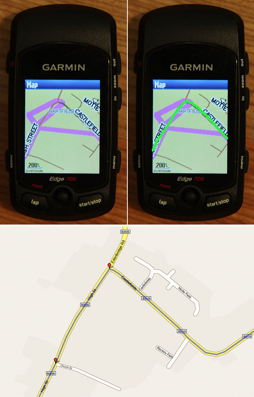
do you have any thoughts on what is causing this and how to remedy. I use http://www.bikeroutetoaster.com for all my routes.
Thanks,
Rich
Hi Rich, I’ve not had anything as bad as that but have lost other peoples Courses then regained them. I think it is down to the algorithym that is used to reduce the number of points. Another thing to do is place the point after the junction so the software knows which way you are going. I’ve placed the point on the junction and it calls the turn in the wrong direction when you place the next point.
I’m also looking at doing GPX routes in Mapsource as you get the bleeps on the turns with no 100 waypoint or coursepoint limit.
Regards,
Frank.
Hi Frank
Am thinking bout getting a 705 road for husbands birthday. Is this still current technology or should I get an iphone?
Thanks
Heidi, this is a good call these days. It depends, if he is a dedicated roadie buy a 705 with map. If not buy a Iphone, both come with health warnings according to techy ability.
A 705 will probably have him coming to a site like this wanting to know how to operate the thing but you wont have to go and pick him up once he does.
An Iphone is a different can of worms, hundreds of thousands of apps but most rely on a good GPRS 3G signal which is hard to come by in the middle of nowhere.
If he has a HRT monitor or cadence sensor go for a 705 as I have a couple of years worth of data to look at now. An Iphone won’t do this yet and the battery won’t last out on an all day ride. The warranty excludes it getting water damaged too.
No wrong answer to this one but be warned they can both be highly addictive.
Regards,
Frank.
Could someone please clarify something for me? I’m thinking of buying a Garmin Edge 705. I live in South Korea, and there’s no point in buying a 705 if I can’t get ahold of some good maps. Is it not possible to use a Google map in an Edge 705? I’ve read the above posts concerning Google maps, but it doesn’t seem clear to me. How can I obtain or make maps for my area?
Thanks
Hi Martin, you’re in a bit of a tight spot. The Garmin World Map is very very basic offering only main highways. I’d opt for a google based device as you can’t use a Google map in a 705.
You will need good GPRS access for a phone. Look at Google maps to see what is on offer.
You could always go the OSM route and upload your routes but I suspect you would be on your own.
Regards,
Frank.
Iphones need a good GPRS signal to be of any use. What do the Taxi drivers use?
Hi Martin
According to the Garmin website there is a Korean City Navigator map available (http://www8.garmin.com/cartography/mpc/#Korea) you’d have to find out locally if it has sufficient detail for what you want (some countries only really cover the major population areas)
Rick
Hi! Great website!
I had (briefly, before my cat knocked it off the kitchen table and broke it!) an Edge 305 and it was a fun geeky toy but I didn’t particularly get to explore it’s navigation abilities. Next year I’m planning on doing some Audaxes in Germany and I’m a triffle concerned that towards the end of a 600[1] my ability to read German may not longer be sufficient for the task.
My current thinking is that an Edge 305 might be able to get me round, but wouldn’t offer to much help if I went too far “off piste”. It seems to me than an Edge 705 might be better in this regard?
[1] I realise that for a 600 I’m going to need additional power!
Hi Alistair, for a 600KM audax one of the newer models with replaceable batteries might be more suited. They are aimed at walkers and I am not up to speed with the latest models as new models are coming out all the time.
A 705 relies on Garmin routable vector maps, the OS version wasn’t routable at first and wasn’t anything like an OS map.
Power although better on a 705 is still only 15 hrs. Although I have used chargers on the move in the past on a 305 they are really tricky on a 705 due to the location of the USB port. It is really tight with an oversize stem fitted on recent bikes. Charging at control points is not feasable.
If you opt to do a Course you have to stick with it through thick and thin as if it is preplanned you won’t get any routing to get back on it. You’ll see the Course as a pink line so it’s not too bad.
Regards,
Frank.
Power is a problem I agree, and since I’m of the “in, stamp, out” persuassion when it comes to controls obviously it would need to be an on-the-go nature. Maybe the wedge for changing the screen angle might give more clearance?
I had been thinking that maybe I could do seperate courses for the segments between each pair of controls? Then if I get seriously off-piste then I could just ask the 705 to route me to the control I was heading for.
Alistair,
Waypoints allways point to the waypoint, on a route you are just navigating a series of waypoints.
The charging will always be a problem on the move. I took pictures of the mounting on an oversize stem and it was really tight and was hit and miss if it worked. Don’t know if I posted the pictures or the article.
Where it could fall apart is if they add control questions that don’t get published along with the route.
To recharge from empty to full is going to take a couple of hours, not minutes so the connection has to be reliable and it isn’t on a 705 and an oversize stem.
Another thing is logging as you have 17,000 points to log, so stop and start after 12 hours, you don’t want it to overwrite your epic ride.
Hats off to anyone who does more than 200k, mention 200km or 125 miles to most and they look at you as if you are mad. It’s hard ennough for them to sit it out in a car.
Regards,
Frank.
Hi Frank.
Recently got out and managed to do an off road with virtually no problems. I downloaded a GPX from a site and the uploaded it into BikeHike and then transferred to the Garmin 705 as a gpxx. I could follow the route fine and it would bleep when I went off route. Excellent!
A few issues though. The map wouldnt always move with me. So as i went along I would sometimes go off the screen and then have to manually navigate to where i was. Annoying
Also, it would always point to north and not rotate with me. I’m sure this is a setting but I couldnt find it. DO you know where it is?
Lastly the only time i went wrong was on a sudden downhill. Obviously I sped up. At the top it said a little way to go and then a sharp left. When I was at the bottom it said I was bang on the sharp left. But then about 10seconds after it showed I had missed the turning and should have been on the path just before. Does the unit use average speed to calculate where you should be and hence when I sped up on the descent I was actually further in front of where it thought I should be?
Any thoughts much appreciated
Cheers
Rob
Rob first off Settings/Map/Orientation/Track up not North Up.
The map not moving might be cured by the above. If you’re riding a Course from BikeHike it will probably at whatever average speed was set in the program.
Regards,
Frank.
Hi Frank
thanks so much for this excellent site! I’ve gone through most of the helpful commentary.
I just purchased the 705 and have the issue that, when routing from e.g. my home to a petrol station, the 705 seems to always want to find some inexplicable detours that increase the distance (with a direct faster road blatantly obvious). This happens both in MapSource and on the device. This happens independent of whichever setting I put (car, bicycle, shortest route, fastest, etc).
I have ensured the 705 software is the latest and I have tried both TOPO as well as city maps.
Anyone had this issue?
Many thanks
Stijn
Netherlands
ps: the BikiHike process from Rob is great for transforming GPX tracks with very little waypoints into one with many waypoints.
is there a software in which you can set a max number of waypoints and it would then automatically find the optimum configuration?
thanks again!
UPDATE: routing problem solved. THis issue was due to the fact that I was using a bike-map which shows highways but aparently is blovking the use of the “larger” type roads. City navigator map works fine.
Hi Frank, I got an Edge 705 ‘bundle’ from my wife this Christmas and your site was recommended by one of my cycling friends who already has a basic edge. A great and very informative site but to be honest my head is spinning by reading the vast array of different comments and tips on many of the 705 benefits / issues ! Looks like a long and steep learning curve ahead ! Just one thing to ask for initially though, in your ‘idiots guide’ you refer to a tutorial about using / renaming an SD Card map so that it can be used in Mapsource or the training Centre – You couldn’t point me to that tutorial could you please, I’ve spent a few hours already hunting but cannot locate it. With hindsight it sounds from your comments that I should have gone for the map on DVD but unfortunately I had no say in the matter and I do not want to appear ungrateful to my wife ! Hope you can help, Cheers, Jeremy.
Hi Frank,
seeing that you have such an array of topics with excellent information, however all mixed up it may be an idea to transform your site into a FORUM? That way you can generate topics to which people can actively contribute. I reckon this will enhance the value of your site even more!
As a further update to the routing i have noticed that the 705 tends to generate quite different routes depending on setting car/bike/pedestrian and the options shortest/fastest/etc. As an example it made a highly complex (slow) route avoiding all highways on a 250km track when i set it too “shortest way”. When set to “fastest” it simply took 2 highways straight to destination. I guess this depends on personal preference and situation, just something to be aware of.
Jeremy try Daves Velorider link at the side of the page. It’s just a case of copying the file onto your computer and renaming it as the pcbasemap. There might be something more recent on the Garmin Connect forum.
Stijn, that’s a great idea. I’ve realised the site has been a bit disjointed for about a year now with the 705 page becoming a bit unmanagable. I’ve been looking at various Themes but a Forum looks like the way to go. I’ve only ever used the internal routeing to see what it comes up with on a trip to the cash machine.
Regards,
Frank.
Jeremy M: I had the same problem and could not find the link to the tutorial, but I did the following.
1) Copied map files from SD card to folder on computer
2) Found location of Training Centre program on PC and backed up (renamed) existing map files
3) Copied files from step 1 to location in step 2
4) renamed files above to be the same as the original map files (basemap2 in my case)
Fired up the training centre and all worked ok – I now have mapping within training centre.
Matt
Frank, Matt,
Many thanks for your advice, I tried what you suggested and it worked fine with the map from the SD card. Mapsource and Training Centre both come up with the new map. Thanks again for your help and I’m sure I’ll be posting more questions soon !
Regards,
Jeremy.
Hi Frank
Santa got me the 605. I’m still getting used to it at the moment, but 1 thing I cant suss out is: I have done a course on mapmyrun, saved it as a .gpx on my pc. Opened the garmin by the usb lead, but I dont know which folder on the garmin 605 to transfer the gpx into, so I can open it and follow my new route. Hope this makes sence. thanks alot
Hi Frank
Great site you’ve started here. Thinking about purchasing the edge but after reading here, thinking real hard. Had the 305 once and wasn’t too bad. I think of the 705 as the same but more obstacles to conquer. Was the edge designed for recording data or for troubleshooting practice. Not sure if intended to be that way but still is tops for being a biking assistant. I enjoy the converse and love how everyone pitches in. Unit and development dept definately needs work. Ride on.
Hi Frank
Just a quick question for you here. I’ve recently got a 705 and City Navigator Europe on DVD. I selected some of the map regions and transferred them over to my Edge using Mapsource, but I think it has put them on the Edge itself, rather than the SD card in the Edge. Do I need to do something specific to put the maps on the SD card (which I bought specifically for doing just that)? I don’t want to fill the internal memory on the unit with maps and not be able to save ride data. Cheers.
Hi, you should be able to do both depending on the area you wish to upload. The map on DVD maybe the best option as it’s your’s and should take under 2 gig to upload.
The 705 should take around 400mB of Data before it is full.
Regards,
Frank.
Hi Frank, Treated myself to a 705 at Christmas “Because I’m Worth It” Not really any problems yet, but can I change the Total Time /Distance settings on my dashbard in player, the first time shown on a 1hr-30 ride is 00:16:40 then 00:33:20. Can I get it sooner an more offten?… How do i set it up to record time & my heart rate on my turbo?
Did some British Championship Windsurfing Speed Events at West Kirby years ago. Windy old town.
Keep on keeping on mate,
All the best
Andy
Hi Frank,
Another 705 newbie. Great gadget but without sites like this what a nightmare.
Looking at a long distance jaunt this summer and need advice on best way to store the route, tcx, crs or gpx.
Plotted route on bikeroutetoaster which shows we will be riding circa 570km from Stuttgart though to Brugge. Seems to plot plenty of course points along cycle frindly roads.
What’s the best way to save from bikeroutetoaster to give me turn by turn navigation?
Any help much appreciated.
Thanks
Paul
Hi Frank, just hoping you can help!! While out my 705 fell off my bike and although the unit works it will not recognise the SD card which fell out! The card had City Nav Europe NT on it and I had not backed it up. I had however transferred it into training centre or at least I think I have as I have a file their named PCbasemap2.img which is 1.52GB in size. Is there anyway of transferring this back to a new SD card and getting the 705 to recognise it?
Hi Frank – great site……been avidly reading for the last hour. I had a 305 a couple of years ago that I just tinkered with and the 705 is a whole different ball game. I still can’t quite get my head around the dilemma and what seem like several options:
1) Base map is crap……..agreed so I looked at downloading the free UK maps on mapomatic – have you found people rate them as I have not had chance to try them as yet?
2) Alternatively do I buy a GB or Europe map……..or if I am planning routes through one of the options mentioned and so working off a pre-planned route then could I feasibly just stick with the basemap?
The reason I am asking is that I mainly do pre-planned rides, normally in the UK – I am doing the Reivers Route in April and so could hopefully upload the course. Then on a summer holiday, usually South of France, I occasionally have my bike and will do a few pre-planned rides that again I can presumably plot and upload before I go or do via my laptop if I take it with me.
So is the only real advantage of going beyond the basemap that you can see detail to recover a ride if you get hopelessly lost, or you can dynamically plan an extra loop whilst actually out on a ride etc? Hope this all makes sense……its not only that I am too tight to buy an add on (just wanna make sure I make the right choice). Comment greatly appreciated
Iain, I’m going to have to get back to you on this one. One alternative is to download the open source maps and look at the format.
I now suffer from map loss due to water ingress due to no uSD card cover.
Mark buy a European map on SD, the base map is useless as a riding map. You should be able to use this with another Garmin gps. You’ll be able to reroute as per a normal gps on the fly as well as planned rides.
It worked well for me last year on the Etape as well as the rides we did through the Ardeche Gourge and the other rides we rode together.
Just to be on the right road is worth it as things are not quite the same the UK when you get lost.
Regards,
Frank.
Howdy Frank,
I’ve got a problem . How can I start at my Home altitude. The atitude is 568m. I want to begin always at this atitude. Thank for
answering me. (Edge 705)
Found this on GarminConnect. Save the Waypoint and use the AVG button to get a better reading.
As stated elsewhere..The latest software does have at least 1 improvement wich could solve the problem for the regular rides.
Set your “home waypoint” altitude correct, and when starting the 705 within 30 meters from this point, it’ll use this as the starting reference altitude
and no more “ups & downs”….
Hi Iain,
Create a ‘Garmin’ directory on your new SD card, and then copy your ‘pc_basemap2.img’ file from C:\Garmin\PCBSMP2 (or wherever it is) into the SD ‘Garmin’ directory and rename it as ‘gmapsupp.img’. The 705 should now recognise it. Then make a backup to DVD 🙂
Cheers,
Richard.
I must be pretty thick:
I’m trying to enter an address in the 705 – not from a PC but in the device itself. I find the postcode, but then what do I do? If I press the ‘Enter’ joystick it takes me back up a level and forgets what I’ve just done. Nothing to suggest anything at all – no ‘Enter’ buttons, or ‘Go to’ or anything like that.
I’ve got City Navigator CN Europe NT 2010.10 on a microSD card. If I take that out then it seems I can find places and ‘Go to’ them.
Grrr!
Frank,
As ever, your site continues to be a source of useful tips and info.
To clarify 535 above, do you set the home waypoint elevation manually or do you rely on the 705 calculating it? If set, does the 705 then take elevation data compared to that setting, rather than the somewhat hit and miss elevation as you ride? Does the home waypoint have to be called ‘Home’?
Oh, by the way, when browsing the Garmin site I stumbled across this
http://www8.garmin.com/learningcenter/training/edge705/index.html
which some may find useful. I’ve had my 705 for 18 months now and only just found it.
Hi everyone, the 705 is on it’s last legs I’ve lost the map I put into the 705 memory along with the ability to have the device recognised by Training centre or GarminConnect. This coupled with a very flacky barometric altimeter.
Onthe last ride it was about 700ft high when it worked, not that I can get the data out of it. It regulary shows gradient of 179% or more. It looks like it needs to go back to Garmin now.
Hi Frank,
I’ve just got an Edge, but it doesn’t recognise the SD Micro card i have in it. I have saved some tcx courses and loaded into Edge, this is fine. When I load them onto the SD card. The edge doesn’t see them. Any ideas?
Thanks and keep up the good work.
Regards Chris H
My Garmin has had PointSec security software loaded (via a work laptop). Although I have the PointSec password to access the device, so information is being stored to the Garmin Hard disk. I can view my ride history in the device menu, but it does not load onto the website, nor is it visable in explorer. Any ideas on how to remove the PointSec software or manually upload the ride history? PointSec have suggested I reformat the Garmin device, but I don’t believe this is possible (soft reset does not resolve the issue).
Thanks
Bruno
Hi Bruno,
if you can’t see the drive in windows you need to do a Hard reset and maybe format the drive. I’ve been through a similar problem in the last week or two. You will loose your basemap if you haven’t backed it up. Try a new USB lead too if your 705 is old and giving you upload problems. I have no idea what PointSec is but you have to get your 705 visible to Windows first. Save valuable rides as a Course first on your 705 before you do a hard reset as you’ll loose all your data.
Frustrating in the extreme as all that data is priceless. I don’t think people realise what it’s like to loose a years worth of ride data as you can’t put it back in.
Regards,
Frank
when riding for more than one day is there a way to save each ride so that when you connect to garmin connect it downloads each ride on the correct day, on a recent multi day ride i shut the edge down each night and when i got home and connected it said i had ridden 200miles non stop!
Steve, simply hold down the lap button which doubles as the reset button for 3 seconds after each ride. When you get back you will find each ride will be treated as seperate.
Dave.
Hi Frank,
Perhaps you can help me. The problem: After save location I get 001; 002; 003; 004;.When I rename waypoint 001; or 002; They stay in the folder. It is for me not possible to delete this points.
Is there any work about to delete the waypoints? Thanks Oldis
I always press ‘stop’ at the end of a ride and then turn the 705 off. It automatically saves that ride and records a new ride when next out. I think.
Hi Bruno,
PointSec is a file encryption software. The usual practice is to install these onto a work laptop. It doesn’t install software onto remote devices but it will encrypt files copied from the local laptop drives to external drives. Encrypted files can only read by the originating host computer (your laptop).
This is to prevent senstive work files being copied to removable devices and taken home to be opened elsewhere. Any encrypted files on your device will not be accessible by Garmin Connect or other website software and a reset will not solve the problem.
You really need to keep your Edge away from your company laptop and use your own machine instead as you may inadvertantly corrupt system files if you access them with your work laptop.
Jon
@ Steve Carter: Did you manage to fix the problem?
Frank,
My 705 is 8 weeks old and worked correctly until last friday. Since this week i cannot connect to PC anymore. When i insert an SDCard, the card is mapped correctly but the ‘Flash’ in 705 is not recognized, the PC only says it is a ‘removeable disk’ and when i try to open it, the PC asks me to format…
I tried:
– reinstall drivers
– remove and reinstall drivers
– install webupdater
– remove and reinstall webupdater
– soft reset
– hard reset
– BootLock
– connect on other PC
Alway’s same result: 2 removable disks are shown but i cannot open them.
Any suggestions?
Firmware 3.1
Drivers 2.3
Patrick, get it back to Garmin as it’s under warranty.
Mine has the same symptoms but won’t recognise a formatted SD card. I put it down to water getting into the card slot.
I enquired about a repair and the long and short of it is the importers don’t have a repair service worth speaking of if it’s out of warranty.
Still using it with a Map in the flash memory. I still have the 305 to fall back on in an emergency.
Regards,
Frank.
I might have another look on the Garmin Connect Forum.
HiFrank Another Edge 705 virgin here. How do I save a route created on bikeroutetoaster to the edge, and then be able to follow this route. There are that many folders and files opening when I plug my edge in to my mac, that it is a lottery. Thanks for providing a service which Garmin, after taking more than £300 of my dosh, should be doing.
Hi noony, it’s under Summary. Save it as a TCX. It’s been a while since I’ve had to plan a route so I’ll be seeing how the height data option works.
It’s a bit of a farce that I can get on the first page of a Google search for Edge related searches 2 years on.
All this stuff should be coming in the box, even the trade locally is reccomending the site if they get stuck.
Regards,
Frank.
How can I find my location by longitude and latitude so I can call it in to my support team to come get me with their GPS system?
Hi Dave,
You need to set the lat/long as the unit, mine was set to British Grid.
On Map mode just move the joystick and up pops your position and the position of the arrow which you can move.
I’ll put this info into the Dummies guide as it is a hidden feature.
Regards,
Frank.
Hi Frank, I’m a mountainbiker who loves to explore unexplored off-road trails. I often get lost in the forest and now I’m looking for a gadget (or GPS) that can assist me to find my way.
I need a gadget that can record my route so that if i get lost I can simply “backtrack” the route I went with to get me back to the starting point.
Also, this gadget must be able to record every new route I explore so that when I go back to ride that particular place I can simply refer to the gadget for the recorded route.
Can any of the Garmin Edge do this?
thanks
hadi
Hi hadi, An Edge would be fine, even the most basic GPS,s would get you back to the start. For off-road you would need a Topo map that has contour lines on it as opposed to Garmin road based routable map.
Have a look at GarminConnect for rides on trails near you. There are a lot of them as people are uploading everything they do to GarminConnect as well as the computer based TrainingCentre.
Regards,
Frank.
Problem with my new Garmin 705.
I made a .gpx route at bikeroutetoaster and saved it on the device under Garmin\GPX\home2work.gpx
When I start the ride I select
Where to? \ Saved Rides \ home2work \ Navigate
but it shows only Time of day and Speed, without map or turn-by-turn indication
if I press mode it shows map (good!) and distance and time of the day, but still no turn-by-turn indication.
If I press mode once more it shows turn-by-turn indication but no map
How do I make it to display turn-by-turn?
Sure, I know how to get towork, cycled it 1000 times, but if I go for a new leisure ride…
Thanks,
Try using http://www.bikehike.co.uk and download as a .gpxx file as I suggested on bikeradar forums today 🙂
Having succesfully used my 705 for 9 months, I deleted my history off the 705 as the lap memory was fully.
Since then, if i try to upload my activities on garmin conncet, it simply does not upload. The 705 is now showing as removabler disk D or G which never happened before.
I can see the activities on the 705 unit, but i cannot upload them.
help is much needed and would be much appreciated from Frank or any others.
Many thanks in advanmce
Save the ride as a Course, a hard reset will loose your history but you will have the ride as a Course. Then contact Garmin, you may need to format the drive. Depending on what software version you are on, you may need to downgrade.
Regards,
Frank.
As another who found this website as a result of needing help with an Edge 705 may I say this is an excellent and interesting web resource……..it’s disappointing one cannot say the same of the Garmin Edge 705. Potential purchasers may be unaware of just how basic this device is in comparison to similar products. One should be aware Garmin offer little in the way of manuals, step by step instructions or web based tutorial. I have even seen opinions expressed suggesting the published PDF makes it difficult to uncover some of the “abilities” of the 705.
As an experienced cyclist I wander quite a lot, stuffing some relevant pages from a road atlas in my pocket, taking turns as I fancy and then referring to the map to navigate to a village etc. if I need to get my bearings. Over the last couple of years I have had the time to go further afield and wanted a device to log and store my routes for uploading to my laptop. This is out of interest, nothing more. I certainly was not looking for a turn by turn SatNav.
At 56 years I’m too old to have received any formal education in the multitude of devices we now view as life essential!! Until I met the Garmin 705 I have never failed with a device. In judging the device standards I’m comparing with TomTom and Apple iPhone, both products which work out of the box, have excellent manuals / tutorials and companies who I feel offer quality products. I had understood Garmin to be a company with similar standards.
The point this post / review is to highlight for potential new users this is not an out of the box product and technically it is very, very dated in terms of user interface etc. First introduced in 2008 it seems there has been no update since then. This is not an easy to use device and requires skills and knowledge I lack and suspect others may also lack. If you buy a 705 be prepared to spend hours with it, which could be better spent on the bike with a map!! I have the HR+CAD plus City Navigator Euro maps on SD card.
The overall feel of the product is rather cheap; plastic outer casing feels just what it is – plastic. Buttons are clunky and generally unresponsive requiring a very firm push to function. Once into the menu system one is met with menus that look like a Nokia phone from 5 years ago, using the joystick which works well one can move up and down and select. Being in the house my first move was to turn the GPS to “Demo Mode” innocently believing this would somehow allow me to practice from the comfort of my armchair. Don’t be fooled no such function exists other than to select a couple of locations on the basic onboard maps which I did and ran the simulation. I chose a simple cycle route I know well, Garmin chose to send me along the M61! This is a product for cyclists. By the way the GPS setting is not saved so every time you switch off you need to go back to reset to the desired choice.
I decided to test the City Navigator maps and started by searching for my home village. TomTom and Google maps are capable of placing me within 3 metres of my backdoor. Selecting “Where To?” I chose the “Find Places” option then “Addresses” and am first required to enter my region (country), the device cannot remember this detail and one needs to scroll from Albania to England every time. Select “Enter City” and one is presented with an A-Z keyboard which has to be navigated around selecting each letter and clicking the joystick to confirm. Entering my home village I discover it doesn’t exist and the closest City Navigator can get is a similarly named village 3 miles away (TomTom is accurate to 3 metres!!). I then select the main street in this village as the street name I wish to navigate to and find the names are incomplete as I scroll through them, that will be useful if trying to chose between say London Road and London Way in Preston – both would show just as London!! I had set my “home” location and allow City to simulate the route for me. Within 500 metres we’ve made a right turn that doesn’t exist, carry on for another mile and make a non-existent left turn but do arrive at the chosen location.
Deciding to test the accuracy I try to move around the maps to locate Chorley, our nearest town. Moving to the screen edge one waits while the spidery roads are redrawn – this is all you get for £40 or so, some brownish red squiggles on a beige background with badly displayed names, almost like a child’s writing. Major road numbers are displayed but I don’t want to use the A roads and motorways. After a while I give up trying to zoom in to Chorley and go back to the search menu. While entering Chorley, City comes up with a whole range of choices from across Europe, it can’t remember I am in ENGLAND. It gives me a handy tip “Enter Main instead of E Main St” Eh? What sort of tip is this? The map takes me to Chorley and we zoom in to what is laughingly called “street level mapping” and now have a mass of brown lines across the screen overlaid with street names and POIs (presumably companies have paid to be included) to such an extent that no useful mapping is visible. Chorley is a small place; I know it well but would not be able to navigate it with City maps.
After an evening and a couple of hours the next morning exploring the 705 I’m left feeling very disappointed, even ripped off. A product priced at £320 should be of high quality, work almost straight out of the box and, given it is for navigation, be equipped with maps fit for purpose. As a cyclist I do not expect to be sent down the M61 when plotting a route, equally on my TomTom I would not anticipate being routed on small rural lanes. TomTom only does this if you ask it to, City Navigator likes to use motorways at every opportunity.
Fortunately Evans Cycles have a 28 day no quibble refunds policy. I shall be returning the device later today. This is undoubtedly the worst piece of cycling kit I have purchased and an appallingly bad piece of technology. Garmin have left me a disappointed customer who would never consider their products again.
From the reviews I have read, I have wanted this device for two years, if one is interested in mapping and computers it appears the Garmin 705 can be made to work, and is in fact a popular piece of kit. If you just want to get on the bike and ride, and for £320 that’s not much to ask, forget it. Try to find something else, that’s my next task! On my Iphone I have Motion X GPS which fulfills all the functions I need to a much, much higher standard and is clear and simple to use. Sadly we all know iPhone battery life is poor and using GPS it’s even worse!! But then it’s a phone not a GPS unit. The Garmin has 15 hour battery life, friends who own the 705 confirm this, £320 is a lot to pay for a better battery. I shall be looking for a piece of kit to extend the battery life on the iPhone.
I hope this gives novices and prospective purchasers a small insight into what they will face after opening the box.
Thanks Paul, probably one of the best comments ever regarding the 705. Encompasses all I’ve been going on about for the last 2 years and even back as far as the 305.
It’s a niche product with some flaws, from the early smartphone days battery life was a problem but now you have to have a good GPRS signal too on your phone. Rides in Wales had me above the cellular network so the best phone in the world or any phone for that matter was next to useless.
It is virtually impossible to charge a phone or Edge on the move, I’ve tried it and it doesn’t work. Smartphone bounced down the road, Edge 305 lost the battery pack and any charging operation isn’t an instant fix. It’s going to take whatever the charging rate is.
A cafe stop isn’t sufficient on a long ride whatever the device.
Edge 705 USB port is blocked by the size of oversized stems, so can’t be charged on the move.
My magor gripe with Garmin is that they don’t do any routing software to plan a ride by. SD cards don’t allow you to use MapSource which makes it a bit pointless.
An Edge 800 with OS Explorer 1:50,000 maps for an extra £50 is a good deal for all of the UK. Not without a new set of bugs and much the same non-existant manual as the rest of the Edge series.
Like everything else these days you have to move with the times, who has a phone that they bought 3 years ago or 18 months for that matter. I’m struggling to get something to play some cassettes that someone has given me.
It may be time for me to add a new 705 or whatever device Comments page.
Regards,
Frank.
Just thought I’d add another point, an Iphone, which I have and is great but I wouldn’t want to go out on a ride with it for the above reasons.
My lad who is in the know says Nokia sell 2.75 million phones a DAY. The money is in a free App with adverts so long as you have a GPRS signal. Everybody likes free.
You seem to like writing long messages Paul 🙂
I guess you are the same Paul from this thread? http://www.cyclechat.net/topic/74673-garmin-website/page__pid__1513592#entry1513592
I tried to offer you help there, but you seem to be quite keen on writing long rants instead of trying to fix your problems?
I was thinking for riding the Salt Lake City Century Ride but then I found the FrontRunner Century Bicycle ride, I think that it will get me ready for the ULCER Ride and for LOTOJA. Your should check out the Front Runner Century Ride at http://www.frontrunnercentury.com as they have no Garmin route listed yet.
I’ve been looking at the 705 recently, now that it is available from around £200. I do a combination of off/on road both for fun and getting to work. So cadence isn’t a big deal for me.
I’ve had a Garmin eTrex Vista HCX with GB TOPO mapping for nearly 3 years, which I got for hill walking. Originally I used a robust RAM mount on my MTB but now use a Garmin oversized bar mount (the Vista is now cheap and old enough for me to no longer be that precious about it).
Both the 705 and eTrex have the older reflective LCD colour screen which are easy to read in reasonable light, without the backlight. They also share many common GPS features: Garmin City Navigator and TOPO mapping, SD card, auto-routing and navigation, electronic compass, barometric altimeter, IPX7 ‘waterproof’, and so on.
For MTB’ing, other than form-factor and being able to mount on the stem I can’t see enough reason to get the 705 over staying with the Vista HCX, so much so that I got a mid-range non-cycling Polar heart rate monitor instead. So why stay with the eTrex?
1. 1000 waypoints. So negates most of the heartache that has been discussed in this excellent blog post.
2. Uses 2 AA batteries, and has settings to let it know that you are using Alkaline, NiMH, Lithium. And they last ages, 24 hours probably, I haven’t checked but I don’t replace them that often to feel they run dry quickly.
3. Can be found from £160, but TOPO is more.
4. It works and I have it already.
And 5. The Polar HRM calculates calories burnt and has a comfortable chest strap: I’ve used the older plastic chest straps that are tight and make you feel like you are about to have a heart attack.
Now if you need the cycle specific features of the 705 (laps, virtual training) then that would swing it, but for better waypoint [read route] capacity the eTrex has it, and the batteries are not sealed in.
And here’s a reason to get a mapping GPS on a bike:
My route to/from work takes me by two rivers (one is the Thames), the other night there was dense low-level mist (about 5-10m forward visibility (on the path but not at eye level) with lights, but only 1 to 2m sideways). I had a route (with 246 waypoints over 21km) already setup so I was able to follow the GPS screen and see where I was and more importantly where the rivers were, and so safely navigate my normal way home.
BTW I wouldn’t advise following an auto-generated route that you didn’t already know, but I have ridden this a fair few times and I had made the gpx route using OS maps on Routebuddy, so was confident that it was safe to follow the GPS.
Can anybody help me with the following: I have been the proud and happy owner of a 705 for a couple of years now. I have never created my own ride, but I frequently upload rides created by others, or for sportives, etc. so that I can ride them.
I’m going away to south of france on hols and have been looking for routes near where I’ll be staying, and I’ve found many. Problem is, the start/end points on these routes are miles from where i’m staying, although some of them go right through the town i’m going to be in.
Is it possible for me to upload these rides to my computer or garmin, and then switch the start end points to the place of my choosing? I’m assuming that if I don’t do this, and go out for a ride, as soon as I press ‘start’, the computer will try and get me back to teh start of the ride, or cause me other grief.
Also, does anybody know of any good routes near Pezenas (Cabrieres)?
Thanks in advance for any assistance.
Derek
Hi Derek,
Hopefully Frank will let me reply to this one.
This is quite a common occurence with Garmin Edge routes. Quite often you’ll want to pick up the route at half-way around or something. The Edge 800 has a prompt when about to follow a route “calculate route to start of ride” that you can either accept or decline. You have a 705, all you need to do is start the route, then simply navigate on screen visually to somewhere on the course, when the 705 has you ‘on course’ you will start to get navigation prompts, when you ride past the apparent ‘end’ of the route, the 705 will probably assume you’ve finished, when this happens simply start the route again and then leave the route at your desired exit.
Personally, what I’d do is go to somewhere like http://www.ridewithgps.com (there are MANY other similar sites) and design your own route starting and leaving near your accomodation, but mirror it closely to any routes you’ve seen online.
I go to the Alps ever summer and usually design my own routes in MapSource before I go and it works perfectly.I’m not familiar with that part of France, but it looks hilly enough on Google terrain view 🙂
Thanks Dave for your help. That should be enough info to get me going.
Cheers
Derek
Dear Frank,
Like many people, I’ve had problems with pre-planned routes on the 705. Following your advice, I’ve tried http://www.bikehike.co.uk and saved the file in .GPXX format (I want to do long rides with turn by turn instructions – this will exceed 100 waypoints). When I save the route on my computer however the format is listed as .GPX rather than.GPXX. Am I doing something wrong?
Great site by the way – I know now that I’m not alone in being baffled
I’ve been exploring for a little bit for any high-quality articles or weblog posts in this sort of house . Exploring in Yahoo I at last stumbled upon this site. Studying this information So i’m glad to show that I’ve a very good uncanny feeling I discovered just what I needed. I most surely will make certain to don?t omit this website and provides it a look regularly.
Hi Frank,
I’ve been using an Edge 705 for about 3 years. In the past week I had 2 separate instances where I recorded training rides and ended up with corrupted distance data. Each ride had an extra distance added (650km and 1700km) to the ride. When I looked at my recorded distance on my Garmin display, I noticed the discrepant value. When I examined the data in Garmin Training Centre, I could see the course plotted correctly on the map portion of the screen, but the distance/speed plots were off, with sudden jumps in speed and distance. I exported the track data as a tcx file and examined the track points more closely using a text editor. The Lat/Long coordinates appear to be correct, which fits with the map display, but from one track point to the next, there is a sudden jump in distance. I don’t see any other abnormalities. When I loo a t a zoomed in view of the map, these distance errors seem to occur when I have stopped on the ride and back tracked 20-30 meters to check something on the road and then resumed my ride. I use the autostop feature when I record rides. I have done a backtrack maneuver many times before and have never seem such an error. Have you ever experienced anything like this?
I contacted Garmin and this is what the reply said: “Nice ride, strange speed and miles. Device must have grabbed a random waypoint adding 1000 miles to the activity. Watching the player you can see exactly where it happened. I’ve done that same thing once with a running watch. I forgot to grab satellites before running and it got me. Your device must have dropped satellites for a brief moment then came back. You might want to factory reset that device if it becomes more frequent.” I assume he was reviewing the data on Garmin Connect. I agree you can see “where” it happens, but not “what” happens. Is there more data recorded than what is shown in the tcx file? I don’t understand what he means by grabbing a random waypoint. Would that not show up in the GPS data and be visible as an impossible jump on the map?
I am just about to try Garmin’s rest advice, but I haven’t found a god explanation for the error yet. Do you have any thoughts or advice? Has anything like this ever happened to you or anyone else you know? Do you know of any way to “clean” the data and display the correct distance?
Thanks,
Anthony
Hi Frank. This is the best site ever for 705 users. I have strange problem with my unit. I’ve had it for over 3 years without issue and now it’s giving me a “Memory Full” error message everytime I switch it on and usually during a ride. I’m pretty sure I have all Maps currently located on the SD card and all HIstory has been removed. I have 484MB free space on the unit and 1.46GB free on the 2GB SD card. I’ve got no idea how to fix this. Any help would be much appreciated.
Fixed it! I discovered I had to actually delete the history on the unit while it not connected to the PC. I’d cleared the history according to all folders on the PC, but when I checked the history while navigating through the unit I noticed 3 years if history there. I don’t know whether this is unique to my unit, a software bug or what.
Hello! I’ve been following your web site for a while now and finally got the bravery to go ahead and give you a shout out from Dallas Texas! Just wanted to say keep up the good work!
Hi Frank and others. I’m thinking about doing some longer rides with my Edge 705 (~6hrs). I’m worried about battery life. Is there a portable charging power supply that works on the go? I mean if I’m halfway through a ride and then plug a power supply in, will the 705 reset back to zero? If not, is there a power supply you’d recommend?
Good day I am so happy I found your blog, I really found you by error, while I was researching on Google for something
else, Anyhow I am here now and would just like to say thanks a lot
for a tremendous post and a all round interesting blog
(I also love the theme/design), I don’t have time to go through it all at the minute but I have saved it
and also added in your RSS feeds, so when I have time I will
be back to read much more, Please do keep up the superb jo.